Difference between revisions of "2010-03-09 42 -72"
imported>Sara (expand subst) |
imported>FippeBot m (Location) |
||
| (One intermediate revision by one other user not shown) | |||
| Line 1: | Line 1: | ||
| − | + | [[Image:{{{image|2010-03-09_42_-72_traditional.jpg}}}|thumb|left]] | |
| − | |||
| − | |||
| − | [[Image:{{{image| | ||
| − | |||
| − | |||
| − | |||
{{meetup graticule | {{meetup graticule | ||
| lat=42 | | lat=42 | ||
| Line 15: | Line 9: | ||
__NOTOC__ | __NOTOC__ | ||
== Location == | == Location == | ||
| − | + | In someone's front yard in Gill, Massachusetts | |
== Participants == | == Participants == | ||
| − | + | [[User:Sara|Sara]], without kids | |
| − | == | + | == Expedition == |
| − | + | My mother watched my kids all day, and my job allows me to make my own hours, so I took advantage of the beautiful weather and the hashpoint which was only a few km from the highway. | |
| − | == | + | === The hashpoint, in Gill, MA === |
| − | + | ||
| + | I drove up to Gill, MA and found convenient parking at a farmstand right across the street from the hashpoint. I figured I had better go buy something since I had parked there, so I went in and discovered that they had local grass-fed beef. This made my day, because I try to use local grass-fed beef instead of factory beef, and I can buy the beef in Springfield only during the months when the farmer's market operates, and we had run out. | ||
| + | |||
| + | I asked the proprietor whether he knew the people across the street and whether he thought they'd mind if I walked around in their yard a little, and he said he didn't think Nancy was home, and therefore she wouldn't mind. | ||
| + | |||
| + | So I crossed the street, found the hashpoint, and marked it with a snowball, which I forgot to photograph. I hadn't expected to find any snow, because at home all our snow melted weeks ago. | ||
| − | = | + | <gallery perrow="3"> |
| − | + | Image:2010-03-09_42_-72_hashbeef.jpg | I figured out only later that the name of the farm comes from "Up in Gill" | |
| + | Image:2010-03-09_42_-72_gps.jpg | I got within about 1m of the hashpoint. | ||
| + | Image:2010-03-09_42_-72_grin.jpg | Stupid enough grin for you? | ||
| + | </gallery> | ||
| − | == | + | === Very Near the Hashpoint === |
| − | < | + | <gallery perrow="3"> |
| − | Image: | + | Image:2010-03-09_42_-72_cowsign.jpg | Maybe the cows really do cross the street sometimes, because there are pastures on both sides. |
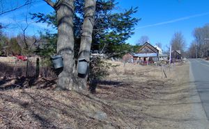
| − | -- | + | Image:2010-03-09_42_-72_traditional.jpg | These buckets are the traditional method of collecting maple sap which is boiled down to make maple syrup. The ration of sap collected to syrup produced is about 40 to 1. |
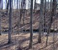
| − | + | Image:2010-03-09_42_-72_modern.jpg | Tubes like this are the more modern way of collecting maple sap. Maple syrup season in Massachusetts is approximately the month of March. | |
</gallery> | </gallery> | ||
| − | + | === Turners Falls, MA === | |
| − | + | ||
| − | + | On the way back, I visited Turners Falls, Massachusetts, a cute little town 8 km from the hashpoint | |
| + | |||
| + | <gallery perrow="3"> | ||
| + | Image:2010-03-09_42_-72_bridge.jpg | A bridge over the Connecticut River and a hydroelectric dam. Turners Falls was originally a mill town. | ||
| + | Image:2010-03-09_42_-72_damsign.jpg | In this litigious society, I'm surprised they even let anyone into the area if there's the slightest chance of danger. | ||
| + | Image:2010-03-09_42_-72_fishsign.jpg | During fish migration season, an elevator helps the fish over the dam, and people can go watch, but I was a couple months early for that. | ||
| + | Image:2010-03-09_42_-72_statue.jpg | Turners Falls has a statue dedicated to the women who worked in the mills. | ||
| + | Image:2010-03-09_42_-72_plaque.jpg | The plaque on the statue. | ||
| + | </gallery> | ||
| − | |||
| − | |||
| − | |||
| − | |||
| − | |||
[[Category:Expeditions]] | [[Category:Expeditions]] | ||
| − | |||
[[Category:Expeditions with photos]] | [[Category:Expeditions with photos]] | ||
| − | |||
| − | |||
| − | |||
| − | |||
| − | |||
[[Category:Coordinates reached]] | [[Category:Coordinates reached]] | ||
| − | + | {{location|US|MA|FR}} | |
| − | |||
| − | |||
| − | |||
| − | |||
| − | |||
| − | |||
| − | |||
| − | |||
| − | |||
Latest revision as of 01:07, 9 August 2019
| Tue 9 Mar 2010 in 42,-72: 42.6473975, -72.4874414 geohashing.info google osm bing/os kml crox |
Location
In someone's front yard in Gill, Massachusetts
Participants
Sara, without kids
Expedition
My mother watched my kids all day, and my job allows me to make my own hours, so I took advantage of the beautiful weather and the hashpoint which was only a few km from the highway.
The hashpoint, in Gill, MA
I drove up to Gill, MA and found convenient parking at a farmstand right across the street from the hashpoint. I figured I had better go buy something since I had parked there, so I went in and discovered that they had local grass-fed beef. This made my day, because I try to use local grass-fed beef instead of factory beef, and I can buy the beef in Springfield only during the months when the farmer's market operates, and we had run out.
I asked the proprietor whether he knew the people across the street and whether he thought they'd mind if I walked around in their yard a little, and he said he didn't think Nancy was home, and therefore she wouldn't mind.
So I crossed the street, found the hashpoint, and marked it with a snowball, which I forgot to photograph. I hadn't expected to find any snow, because at home all our snow melted weeks ago.
Very Near the Hashpoint
Turners Falls, MA
On the way back, I visited Turners Falls, Massachusetts, a cute little town 8 km from the hashpoint


