Difference between revisions of "2010-04-13 47 7"
imported>Crox (report!) |
imported>FippeBot m (Location) |
||
| (4 intermediate revisions by one other user not shown) | |||
| Line 6: | Line 6: | ||
== Location == | == Location == | ||
| − | Dulliken, near Olten | + | [[wikipedia:Dulliken|Dulliken]], near Olten |
| + | |||
| + | == Participants == | ||
| + | *[[user:Crox|Crox]] | ||
== Expedition == | == Expedition == | ||
| − | + | Looking at the coordinates yesterday, I was happy to see a possibility for a second [[2009-10-14_47_8|army geohash]] and at the same time an upgrade to my [[Minesweeper_Geohash|minesweeper]] level. | |
| − | I went by train to Olten, then by bus to | + | Planning began when I was on the train to Bern, and subsequently an expedition planning page was created. |
| + | |||
| + | I went by train to Olten, then by bus to Obergösgen, then another bus brought me to the "Bodenacker" bus stop in Dulliken, just a few dozen metres from the hash. | ||
The exact coordinates were indeed very quickly reached. After taking a few pictures I walked to the Dulliken train station to take a train back to Olten. | The exact coordinates were indeed very quickly reached. After taking a few pictures I walked to the Dulliken train station to take a train back to Olten. | ||
| + | |||
| + | The initial report including pictures upload was entirely done on the way back, thanks to my trusty [[wikipedia:Nokia_N810|N810]]. | ||
| Line 30: | Line 37: | ||
[[Category:Expeditions]] | [[Category:Expeditions]] | ||
[[Category:Coordinates reached]] | [[Category:Coordinates reached]] | ||
| + | [[Category:army]] | ||
| + | {{location|CH|SO}} | ||
Latest revision as of 01:36, 9 August 2019
| Tue 13 Apr 2010 in 47,7: 47.3531733, 7.9513002 geohashing.info google osm bing/os kml crox |
Contents
Location
Dulliken, near Olten
Participants
Expedition
Looking at the coordinates yesterday, I was happy to see a possibility for a second army geohash and at the same time an upgrade to my minesweeper level.
Planning began when I was on the train to Bern, and subsequently an expedition planning page was created.
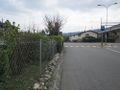
I went by train to Olten, then by bus to Obergösgen, then another bus brought me to the "Bodenacker" bus stop in Dulliken, just a few dozen metres from the hash.
The exact coordinates were indeed very quickly reached. After taking a few pictures I walked to the Dulliken train station to take a train back to Olten.
The initial report including pictures upload was entirely done on the way back, thanks to my trusty N810.
Photos
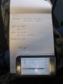
Planning on the train...
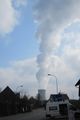
Cooling tower of the Gösgen nuclear plant, not far from the hash.
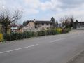
The hash is there.
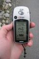
Coordinates reached!
From the hash.

Sergeant Crox at the hash.


