Difference between revisions of "2010-04-22 32 -117"
imported>Scerruti (a live expedition message sent via geohashdroid for android.) |
imported>FippeBot m (Location) |
||
| (11 intermediate revisions by 2 users not shown) | |||
| Line 1: | Line 1: | ||
| − | |||
<!-- If you did not specify these parameters in the template, please substitute appropriate things for IMAGE, LAT, LON, and DATE (YYYY-MM-DD format) | <!-- If you did not specify these parameters in the template, please substitute appropriate things for IMAGE, LAT, LON, and DATE (YYYY-MM-DD format) | ||
| Line 15: | Line 14: | ||
__NOTOC__ | __NOTOC__ | ||
== Location == | == Location == | ||
| − | + | Close to 3800 Calle Fortunada, San Diego, CA | |
== Participants == | == Participants == | ||
| − | + | [[User:scerruti|Stephen Cerruti]] | |
== Plans == | == Plans == | ||
<!-- what were the original plans --> | <!-- what were the original plans --> | ||
| + | Plans? Who makes plans? I downloaded the Geohash Droid application yesterday, checked out the closest point today and went. The only plan I made was not to stop at the 7 Eleven a few hundred meters south to earn the Geosquishy achievement. | ||
== Expedition == | == Expedition == | ||
<!-- how it all turned out. your narrative goes here. --> | <!-- how it all turned out. your narrative goes here. --> | ||
| + | I got in the van, started up Waze and searched for a road near the point. I made the mistake of turning on Calle Fortunada (how unfortunate) and then having to go back out on Ruffin. The point was just off the driveway up the the YMCA. There is a sign out on Ruffin. I stopped in the van initially but then decided to drive up into the parking lot and walk back down to try to get as exact as possible. | ||
| + | |||
| + | While I am walking down the hill my boss calls and asks me how to set up corporate email on his MacBook. Once that was resolved I was able to narrow down the location. | ||
| + | |||
| + | I don't know if the photo is exact, the Droid's GPS was drifting a little and I couldn't get the latitude to go lower even when I hung it out over the edge of the ravine. This would have been a great geosquishy site, but I will save that for another expedition. | ||
| + | <!-- Nothing is this section > | ||
== Tracklog == | == Tracklog == | ||
<!-- if your GPS device keeps a log, you may post a link here --> | <!-- if your GPS device keeps a log, you may post a link here --> | ||
| − | == Photos == | + | == Photos == |
| − | < | + | <gallery> |
| − | Image: | + | Image:2010-04-22_32_-117_13-35-09-281.jpg | Ooh, that's steep! [http://www.openstreetmap.org/?lat=32.81112265&lon=-117.12061636666667&zoom=16&layers=B000FTF @32.8111,-117.1206] |
| − | -- | ||
| − | |||
</gallery> | </gallery> | ||
| + | |||
| + | == Achievements == | ||
| + | {{land geohash | ||
| + | | latitude = 32 | ||
| + | | longitude = -117 | ||
| + | | date = 2010-04-22 | ||
| + | | name = scerruti | ||
| + | | image = 2010-04-22_32_-117_13-35-09-281.jpg | ||
| + | }} | ||
| − | |||
| − | |||
| − | |||
| − | |||
| − | |||
| − | |||
| − | |||
| − | |||
| − | |||
[[Category:Expeditions]] | [[Category:Expeditions]] | ||
| − | |||
[[Category:Expeditions with photos]] | [[Category:Expeditions with photos]] | ||
| − | |||
| − | |||
| − | |||
| − | |||
[[Category:Coordinates reached]] | [[Category:Coordinates reached]] | ||
| − | + | {{location|US|CA|SD}} | |
| − | |||
| − | |||
| − | |||
| − | |||
| − | |||
| − | |||
| − | |||
| − | |||
| − | |||
Latest revision as of 01:42, 9 August 2019
| Thu 22 Apr 2010 in 32,-117: 32.8110322, -117.1206248 geohashing.info google osm bing/os kml crox |
Location
Close to 3800 Calle Fortunada, San Diego, CA
Participants
Plans
Plans? Who makes plans? I downloaded the Geohash Droid application yesterday, checked out the closest point today and went. The only plan I made was not to stop at the 7 Eleven a few hundred meters south to earn the Geosquishy achievement.
Expedition
I got in the van, started up Waze and searched for a road near the point. I made the mistake of turning on Calle Fortunada (how unfortunate) and then having to go back out on Ruffin. The point was just off the driveway up the the YMCA. There is a sign out on Ruffin. I stopped in the van initially but then decided to drive up into the parking lot and walk back down to try to get as exact as possible.
While I am walking down the hill my boss calls and asks me how to set up corporate email on his MacBook. Once that was resolved I was able to narrow down the location.
I don't know if the photo is exact, the Droid's GPS was drifting a little and I couldn't get the latitude to go lower even when I hung it out over the edge of the ravine. This would have been a great geosquishy site, but I will save that for another expedition.
Photos
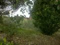
Ooh, that's steep! @32.8111,-117.1206

Achievements
scerruti earned the Land geohash achievement
|