Difference between revisions of "2010-04-23 33 -84"
imported>Ramblingwreck (→Gallery: fixed broken image link) |
m |
||
| (7 intermediate revisions by 3 users not shown) | |||
| Line 1: | Line 1: | ||
{{meetup graticule | {{meetup graticule | ||
| − | |||
| lat=33 | | lat=33 | ||
| lon=-84 | | lon=-84 | ||
| Line 20: | Line 19: | ||
=== [[User:NWoodruff|NWoodruff]] === | === [[User:NWoodruff|NWoodruff]] === | ||
| + | |||
| + | This is the last expedition before my truck was broken into and my camera and GPS was stolen. | ||
| + | |||
| + | I had gone to Stone Mountain with my now ex-girlfriend and her kids for the day the day after this expedition. I had assumed that the memory stick that I used all the time was in the camera when it was stolen. | ||
| + | |||
| + | I had forgot that earlier that day I has swapped out the 16Gb card for a 2Gb card because I wanted to be able to give the memory card to my girlfriend to have the pictures of her kids printed at the local camera shop. | ||
| + | |||
| + | I have 2 16Gb micro memory cards for my camera and I wrongly assumed that this one was the backup memory card in case I forgot the primary memory card in my computer. I've done that several times now. When I found the backup 16Gb memory card this morning, I was ecstatic to remember that I has swapped out the primary card for the 2Gb card. | ||
| + | |||
| + | So, now a month later, I am uploading the pictures. | ||
==== Gallery ==== | ==== Gallery ==== | ||
<gallery perrow="3"> | <gallery perrow="3"> | ||
| − | Image: | + | Image:2010042333-84NW01.JPG | 176 feet, as close as I could get. |
| + | Image:2010042333-84NW02.JPG | The time of the meetup. | ||
| + | Image:2010042333-84NW03.JPG | Date of the meetup. | ||
| + | Image:2010042333-84NW04.JPG | It is kind of hard to see but in the center of the picture are 3 fish and the bottom left are 2 fish that swam up expecting to be fed. | ||
| + | Image:2010042333-84NW05.JPG | 11 feet accuracy. | ||
| + | Image:2010042333-84NW06.JPG | The actual hash spot is somewhere out.... there... | ||
| + | Image:2010042333-84NW07.JPG | It is a very pretty place to be. | ||
| + | Image:2010042333-84NW08.JPG | Me near the hash spot. | ||
| + | Image:2010042333-84NW09.JPG | A great walking trail leads to near the hash spot. | ||
| + | Image:2010042333-84NW10.JPG | My kingdom for a boat? | ||
</gallery> | </gallery> | ||
| − | |||
| − | |||
| Line 32: | Line 48: | ||
[[Category:Expeditions with photos]] | [[Category:Expeditions with photos]] | ||
[[Category:Coordinates not reached]] | [[Category:Coordinates not reached]] | ||
| + | [[Category:Not reached - Mother Nature]] | ||
| + | {{location|US|GA|CB}} | ||
Latest revision as of 10:45, 24 April 2022
| Fri 23 Apr 2010 in Atlanta: 33.8186424, -84.5508839 geohashing.info google osm bing/os kml crox |
Graticule
About
A rare water geohash in a subdivision in Mableton Georgia.
Expedition
NWoodruff
This is the last expedition before my truck was broken into and my camera and GPS was stolen.
I had gone to Stone Mountain with my now ex-girlfriend and her kids for the day the day after this expedition. I had assumed that the memory stick that I used all the time was in the camera when it was stolen.
I had forgot that earlier that day I has swapped out the 16Gb card for a 2Gb card because I wanted to be able to give the memory card to my girlfriend to have the pictures of her kids printed at the local camera shop.
I have 2 16Gb micro memory cards for my camera and I wrongly assumed that this one was the backup memory card in case I forgot the primary memory card in my computer. I've done that several times now. When I found the backup 16Gb memory card this morning, I was ecstatic to remember that I has swapped out the primary card for the 2Gb card.
So, now a month later, I am uploading the pictures.
Gallery
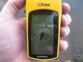
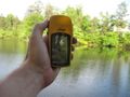
176 feet, as close as I could get.
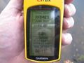
The time of the meetup.
Date of the meetup.
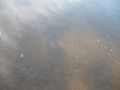
It is kind of hard to see but in the center of the picture are 3 fish and the bottom left are 2 fish that swam up expecting to be fed.
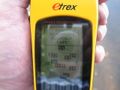
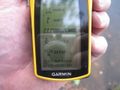
11 feet accuracy.
The actual hash spot is somewhere out.... there...
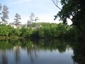
It is a very pretty place to be.

Me near the hash spot.
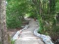
A great walking trail leads to near the hash spot.
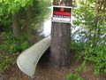
My kingdom for a boat?


