Difference between revisions of "2010-04-25 50 17"
imported>Charfa (Created page with '{{subst:Expedition |lat = 50 |lon = 17 |date = 2010-04-25 }}') |
m (per Renaming Proposal) |
||
| (6 intermediate revisions by 2 users not shown) | |||
| Line 1: | Line 1: | ||
| − | |||
| − | |||
| − | |||
| − | |||
| − | |||
| − | |||
| − | |||
{{meetup graticule | {{meetup graticule | ||
| lat=50 | | lat=50 | ||
| Line 12: | Line 5: | ||
}} | }} | ||
| − | |||
__NOTOC__ | __NOTOC__ | ||
== Location == | == Location == | ||
| − | + | On a field between Bogunów and Polakowice, 10km south of Wrocław. | |
== Participants == | == Participants == | ||
| − | + | * [[User:charfa|charfa]] | |
| − | == | + | == Expedition == |
| − | + | On a beautiful sunny Sunday ("sunny Sunday", hehe) I left home in early afternoon with everything I needed to make it yet another successful geohashing attempt: my bike, my camera and my GPS. It only turned out later that two of those three things failed (only partially though). | |
| − | == | + | Initially I planned on following the banks of Ślęza river from my home to Bogunów but after few km there were no more tracks to follow. I resorted to using normal roads and just then found that my cyclocomputer (or whatever English speakers call it, I just found the name on wikipedia) had gone broke, probably batteries were down. So, I would have no idea how far from home I am ;). Nevertheless I kept going, passed a few villages (Ślęza, Karwiany, Suchy Dwór, Żórawina, Żerniki Wielkie), riding mostly on paved roads. In Bogunów I turned on my GPS to check where exactly I should turn from the road to find the hashpoint and noticed that its batteries were getting low as well. I turned it off and hurried up through fields, having my butt bumped heavily on a field way. Past the railway, around the forest and it should be somewhere here. I took my GPS out again and followed its directions. When I was almost on the spot I switched the display to show me current coordinates and *puff*. |
| − | + | ||
| + | It was dead. Thus I don't have a proof of reaching coordinates. I even cannot be 100% sure that I reached them, however the green arrow was just over the checkered flag when I attempted to read out actual coordinates, so I'm pretty sure I made it. I just hope the panorama I took will suffice as a proof. I think that's enough for Coordinates reached, but I'm not gonna claim any achievements until somebody confirms it. | ||
| + | |||
| + | I then continued through fields to Polakowice and then straight north to Wrocław, back home. | ||
| + | |||
| + | == Achievements == | ||
| + | Ok, somebody did confirm that I'm elligible to do this, so here are my achievements :D | ||
| − | == | + | Distance cycled is a rough estimate taken from Google Earth. |
| − | + | {{Bicycle geohash | |
| + | | latitude = 50 | ||
| + | | longitude = 17 | ||
| + | | date = 2010-04-25 | ||
| + | | name = charfa | ||
| + | | distance = 45km | ||
| + | }} | ||
| + | {{Graticule unlocked | ||
| + | | latitude = 50 | ||
| + | | longitude = 17 | ||
| + | | date = 2010-04-25 | ||
| + | | name = charfa | ||
| + | }} | ||
== Photos == | == Photos == | ||
| − | |||
| − | |||
| − | |||
<gallery perrow="4"> | <gallery perrow="4"> | ||
| + | Image:2010_04_25_50_17_Mecz.jpg|A football match taking place in Karwiany while I was passing by. And that's a goal! | ||
| + | Image:2010_04_25_50_17_Kosciol.jpg|A picturesque church in Żórawina. | ||
| + | Image:2010_04_25_50_17_Panorama.jpg|Panorama I took from the hashpoint location... | ||
| + | Image:2010_04_25_50_17_Mapa.jpg|... and a detailed map, for comparison. | ||
</gallery> | </gallery> | ||
| − | |||
| − | |||
| − | |||
| − | |||
| − | |||
| − | |||
| − | |||
| − | |||
| − | |||
| − | |||
[[Category:Expeditions]] | [[Category:Expeditions]] | ||
| − | |||
[[Category:Expeditions with photos]] | [[Category:Expeditions with photos]] | ||
| − | |||
| − | |||
| − | |||
| − | |||
[[Category:Coordinates reached]] | [[Category:Coordinates reached]] | ||
| − | + | {{location|PL|D|WR}} | |
| − | |||
| − | |||
| − | |||
| − | |||
| − | |||
| − | |||
| − | |||
| − | |||
| − | |||
Latest revision as of 06:14, 20 March 2024
| Sun 25 Apr 2010 in 50,17: 50.9440030, 17.0453958 geohashing.info google osm bing/os kml crox |
Location
On a field between Bogunów and Polakowice, 10km south of Wrocław.
Participants
Expedition
On a beautiful sunny Sunday ("sunny Sunday", hehe) I left home in early afternoon with everything I needed to make it yet another successful geohashing attempt: my bike, my camera and my GPS. It only turned out later that two of those three things failed (only partially though).
Initially I planned on following the banks of Ślęza river from my home to Bogunów but after few km there were no more tracks to follow. I resorted to using normal roads and just then found that my cyclocomputer (or whatever English speakers call it, I just found the name on wikipedia) had gone broke, probably batteries were down. So, I would have no idea how far from home I am ;). Nevertheless I kept going, passed a few villages (Ślęza, Karwiany, Suchy Dwór, Żórawina, Żerniki Wielkie), riding mostly on paved roads. In Bogunów I turned on my GPS to check where exactly I should turn from the road to find the hashpoint and noticed that its batteries were getting low as well. I turned it off and hurried up through fields, having my butt bumped heavily on a field way. Past the railway, around the forest and it should be somewhere here. I took my GPS out again and followed its directions. When I was almost on the spot I switched the display to show me current coordinates and *puff*.
It was dead. Thus I don't have a proof of reaching coordinates. I even cannot be 100% sure that I reached them, however the green arrow was just over the checkered flag when I attempted to read out actual coordinates, so I'm pretty sure I made it. I just hope the panorama I took will suffice as a proof. I think that's enough for Coordinates reached, but I'm not gonna claim any achievements until somebody confirms it.
I then continued through fields to Polakowice and then straight north to Wrocław, back home.
Achievements
Ok, somebody did confirm that I'm elligible to do this, so here are my achievements :D
Distance cycled is a rough estimate taken from Google Earth.
charfa earned the Bicycle geohash achievement
|
charfa earned the Graticule Unlocked Achievement
|
Photos
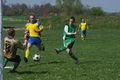
A football match taking place in Karwiany while I was passing by. And that's a goal!
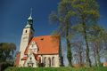
A picturesque church in Żórawina.
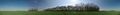
Panorama I took from the hashpoint location...
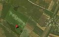
... and a detailed map, for comparison.


