Difference between revisions of "2010-05-02 55 -111"
imported>B cereus |
m (per Renaming Proposal) |
||
| (18 intermediate revisions by 6 users not shown) | |||
| Line 1: | Line 1: | ||
| − | |||
<!-- If you did not specify these parameters in the template, please substitute appropriate things for IMAGE, LAT, LON, and DATE (YYYY-MM-DD format) | <!-- If you did not specify these parameters in the template, please substitute appropriate things for IMAGE, LAT, LON, and DATE (YYYY-MM-DD format) | ||
| Line 15: | Line 14: | ||
__NOTOC__ | __NOTOC__ | ||
== Location == | == Location == | ||
| − | + | On township road 734A, 14km east of Highway 881. | |
| − | == Participants == | + | == Participants == |
| − | + | [[User:B cereus|B cereus]] | |
== Plans == | == Plans == | ||
| − | + | The iPhone Geohash app showed this location to be a fairly short drive away from the drilling rig I'm working at. Satellite view shows roads that aren't on the road maps which would allow a multiple achievement virgin tron speedracer land hash. Since I'm on nightshift, I'll get up on the early afternoon and try this geohashing thing | |
== Expedition == | == Expedition == | ||
| − | + | Success! Got to my first geohash location. I left 2 hours before my shift, which should have been plenty of time. The shortcut I saw from satellite maps turned out to be a cutline and not a road, so I had to backtrack 25km to the highway. Guess I'll have to try tron another day. | |
| + | I was all setup to take speedracer picture when Kazza said "turn left now". Stupid iPhone lied. The location turned out to be a couple hundred meters off the road. I should probably tell you that Kazza is the voice of my Nuvi. | ||
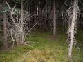
| + | Armed with my bear safety kit, I walked across an open field then into a mossy floored lichen covered pine forest. The day before, I had just seen an emaciated cinnamon coloured Black Bear who looked VERY hungry after hibernating, so I was a bit nervous while in the forest. I quickly got to the location, took my pics of proof, stupid grin included, and got the heck out of there. I arrived back at work only one hour late. | ||
| − | == | + | == Photos == |
| − | |||
| − | |||
| − | |||
| − | |||
| − | |||
<gallery perrow="4"> | <gallery perrow="4"> | ||
| + | Image:2010-05-02 55 -111 01.jpg | | ||
| + | Image:2010-05-02 55 -111 02.jpg | Sickly swamp pines | ||
| + | Image:2010-05-02 55 -111 03.jpg | I really need a handheld GPSR | ||
| + | Image:2010-05-02 55 -111 04.jpg | Obligatory stupid grin | ||
| + | Image:2010-05-02 55 -111 05.jpg | | ||
| + | Image:2010-05-02 55 -111 06.jpg | This is my other car | ||
| + | Image:2010-05-02 55 -111 07.jpg | Back to work | ||
</gallery> | </gallery> | ||
| + | {{land geohash | ||
| + | | latitude = 55 | ||
| + | | longitude = -111 | ||
| + | | date = 2010-05-02 | ||
| + | | name = B cereus | ||
| + | | image = 2010-05-02 55 -111 04.jpg | ||
| + | }} | ||
| + | |||
| + | {{Graticule unlocked | ||
| + | | latitude = 55 | ||
| + | | longitude = -111 | ||
| + | | date = 2010-05-02 | ||
| + | | name = B cereus | ||
| + | }} | ||
| − | |||
| − | |||
| − | |||
| − | |||
| − | |||
| − | |||
| − | |||
| − | |||
[[Category:Expeditions]] | [[Category:Expeditions]] | ||
| − | + | [[Category:Coordinates reached]] | |
[[Category:Expeditions with photos]] | [[Category:Expeditions with photos]] | ||
| − | + | {{location|CA|AB|BI}} | |
| − | |||
| − | |||
| − | |||
| − | |||
| − | |||
| − | |||
| − | |||
| − | |||
| − | |||
| − | |||
| − | |||
| − | |||
| − | |||
| − | |||
| − | |||
Latest revision as of 06:13, 20 March 2024
| Sun 2 May 2010 in 55,-111: 55.3530534, -111.0108065 geohashing.info google osm bing/os kml crox |
Location
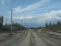
On township road 734A, 14km east of Highway 881.
Participants
Plans
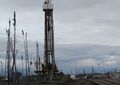
The iPhone Geohash app showed this location to be a fairly short drive away from the drilling rig I'm working at. Satellite view shows roads that aren't on the road maps which would allow a multiple achievement virgin tron speedracer land hash. Since I'm on nightshift, I'll get up on the early afternoon and try this geohashing thing
Expedition
Success! Got to my first geohash location. I left 2 hours before my shift, which should have been plenty of time. The shortcut I saw from satellite maps turned out to be a cutline and not a road, so I had to backtrack 25km to the highway. Guess I'll have to try tron another day. I was all setup to take speedracer picture when Kazza said "turn left now". Stupid iPhone lied. The location turned out to be a couple hundred meters off the road. I should probably tell you that Kazza is the voice of my Nuvi. Armed with my bear safety kit, I walked across an open field then into a mossy floored lichen covered pine forest. The day before, I had just seen an emaciated cinnamon coloured Black Bear who looked VERY hungry after hibernating, so I was a bit nervous while in the forest. I quickly got to the location, took my pics of proof, stupid grin included, and got the heck out of there. I arrived back at work only one hour late.
Photos
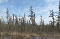
Sickly swamp pines
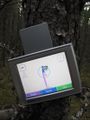
I really need a handheld GPSR
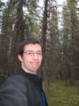
Obligatory stupid grin
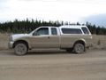
This is my other car
Back to work


B cereus earned the Land geohash achievement
|
B cereus earned the Graticule Unlocked Achievement
|