Difference between revisions of "2010-05-04 35 -106"
From Geohashing
imported>Redaragorn (Created page with '{{meetup graticule | lat=35 | lon=-106 | date=2010-05-04 }} == Location == A nondescript street corner in a residential subdivision on the west side of Albuquerque. == Partici…') |
imported>FippeBot m (Location) |
||
| (One intermediate revision by one other user not shown) | |||
| Line 29: | Line 29: | ||
<gallery> | <gallery> | ||
| − | Image:2010-05-04 35 -106 - GPS. | + | Image:2010-05-04 35 -106 - GPS.jpg|GPS coordinates |
Image:2010-05-04 35 -106 - grin.jpg|Grin - family was in the car | Image:2010-05-04 35 -106 - grin.jpg|Grin - family was in the car | ||
| Line 38: | Line 38: | ||
[[Category:Expeditions]] | [[Category:Expeditions]] | ||
[[Category:Coordinates reached]] | [[Category:Coordinates reached]] | ||
| + | {{location|US|NM|BE}} | ||
Latest revision as of 01:53, 9 August 2019
| Tue 4 May 2010 in 35,-106: 35.1326497, -106.7073216 geohashing.info google osm bing/os kml crox |
Location
A nondescript street corner in a residential subdivision on the west side of Albuquerque.
Participants
- Redaragorn and family
Plans
A busy workday, so I can't get out early. Will try to pile the family in the car after work and hit the hash.
Expedition
Drove on down...not quite 10 miles away. I was thinking about running there and back, but having just run my first marathon on Saturday the 1st, I wasn't quite ready for a 20 miler follow up. Hit the hash easy as pie and headed back home. Not high on the adventure side, but it was fun to get there anyway.
Track
n/a - parked around the corner
Pictures
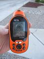
GPS coordinates

Grin - family was in the car

