Difference between revisions of "2010-06-05 40 -74"
From Geohashing
imported>Jiml m (Adjust Result codes - this may be as complete as the report gets) |
imported>FippeBot m (Location) |
||
| (2 intermediate revisions by 2 users not shown) | |||
| Line 41: | Line 41: | ||
{{#vardefine:ribbonwidth|800px}} | {{#vardefine:ribbonwidth|800px}} | ||
<!-- Add any achievement ribbons you earned below, or remove this section --> | <!-- Add any achievement ribbons you earned below, or remove this section --> | ||
| − | + | {{Land geohash|name=[[User:mowdownjoe|mowdownjoe]]|date=2010-06-05 |latitude=40 |longitude=-74}} | |
| Line 48: | Line 48: | ||
[[Category:Expeditions with photos]] | [[Category:Expeditions with photos]] | ||
| − | |||
[[Category:Coordinates reached]] | [[Category:Coordinates reached]] | ||
| − | |||
<!-- or if you failed :( | <!-- or if you failed :( | ||
| Line 60: | Line 58: | ||
[[Category:Not reached - Did not attempt]] | [[Category:Not reached - Did not attempt]] | ||
--> | --> | ||
| + | {{location|US|NJ|MN}} | ||
Latest revision as of 02:18, 9 August 2019
| Sat 5 Jun 2010 in 40,-74: 40.4318804, -74.2300218 geohashing.info google osm bing/os kml crox |
Location
The parking lot of the Matawan/Aberdeen Middle School
Participants
Plans
Expedition
- Hash landed me near the parking lot of the Matawan/Aberdeen Middle School. If there was a meet-up, I missed it. -- Mowdownjoe @40.4319,-74.2301 21:49, 5 June 2010 (UTC)
Photos
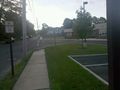
It's always nice when your first successful Geohash is actually relatively local to your home. @40.4319,-74.2300

Achievements
mowdownjoe earned the Land geohash achievement
|