Difference between revisions of "2010-06-13 47 12"
imported>Reinhard (→Photos) |
imported>FippeBot m (Location) |
||
| (One intermediate revision by one other user not shown) | |||
| Line 15: | Line 15: | ||
== Expedition == | == Expedition == | ||
| − | + | Manu and Reinhard were on a short vacation in Tyrol/Austria from Wednesday evening till Sunday. There was no close hashpoint during their stay, but this reasonable one on Sunday which they could visit on their drive back. As the public internet PC in a restaurant didn't display the peeron map and satellite view, they just knew from the Garmin roadmap that it was close to roads. Taking A93 exit Oberaudorf shortly after crossing the Austrian-German border, they quickly got close to the hashpoint and drove a gravel road as far as possible. It turned out that the hashpoint was on a meadow without any animals, so they went the 400 m there and took some pictures. New graticule for Manu and Reinhard successfully geohashed! Then they went back to the car and continued their drive home (having a longer break in Munich). | |
== Photos == | == Photos == | ||
| Line 30: | Line 30: | ||
[[Category:Expeditions with photos]] | [[Category:Expeditions with photos]] | ||
[[Category:Coordinates reached]] | [[Category:Coordinates reached]] | ||
| + | {{location|DE|BY|RO}} | ||
Latest revision as of 02:25, 9 August 2019
| Sun 13 Jun 2010 in 47,12: 47.6961531, 12.1499792 geohashing.info google osm bing/os kml crox |
Location
On a meadow in the rural district of Rosenheim (Bavaria, Germany) close to the Austrian border.
Participants
Expedition
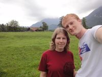
Manu and Reinhard were on a short vacation in Tyrol/Austria from Wednesday evening till Sunday. There was no close hashpoint during their stay, but this reasonable one on Sunday which they could visit on their drive back. As the public internet PC in a restaurant didn't display the peeron map and satellite view, they just knew from the Garmin roadmap that it was close to roads. Taking A93 exit Oberaudorf shortly after crossing the Austrian-German border, they quickly got close to the hashpoint and drove a gravel road as far as possible. It turned out that the hashpoint was on a meadow without any animals, so they went the 400 m there and took some pictures. New graticule for Manu and Reinhard successfully geohashed! Then they went back to the car and continued their drive home (having a longer break in Munich).
Photos
|


