Difference between revisions of "2010-06-21 49 9"
imported>Danatar (Report! pictures will follow) |
imported>FippeBot m (Location) |
||
| (4 intermediate revisions by one other user not shown) | |||
| Line 8: | Line 8: | ||
== Location == | == Location == | ||
| − | Today's location is in the ''Gramschatzer Wald'' forest. | + | Today's location is a few metres from a forest track in the ''Gramschatzer Wald'' forest. |
Country: Germany; state: Bayern (Bavaria, EU:DE:BY); administrative region: Unterfranken; district: Würzburg rural district | Country: Germany; state: Bayern (Bavaria, EU:DE:BY); administrative region: Unterfranken; district: Würzburg rural district | ||
| Line 18: | Line 18: | ||
===[[User:Danatar|Danatar]]=== | ===[[User:Danatar|Danatar]]=== | ||
| − | When I started out, the clouds had some dark parts, but I just hoped for the weather be stay dry and so it did. I cycled to Rimpar, where I forgot to take the field track I usually use, so I had to climb the next hill (~100 m elevation) on the country road used by many cars. I survived. Not much later I turned onto a forest track which | + | When I started out, the clouds had some dark parts, but I just hoped for the weather be stay dry and so it did. I cycled to Rimpar, where I forgot to take the field track I usually use, so I had to climb the next hill (~100 m elevation) on the country road used by many cars. I survived. Not much later I turned onto a forest track which was in surprisingly good condition and led me to the hashpoint. I took the first look at my GPS unit 500 m from the hashpoint, then cycled with the GPS unit in hand. The GPS receiver died. I stopped to take the spare batteries out of my bag, but found out that the spare batteries must habe been the ones on my kitchen table. Meh. So I took the other GPS receiver instead. After cycling a bit too far because the GPS was lagging behind, I stood on the forest track near the hashpoint. The GPS receiver told me "9 m north", I went there, it said "6 m west", I went there, it said "12 m north", I went there, it said "36 m south and 18 m east"... In short, it was the longest GPS dance I ever did, and this time it was not to get that last decimal correct but to get a picture of the unit showing me within something like 10 metres or less. The indicated distance jumped far to every side, and whenever I saw mostly correct coordinates they were gone before I could take a picture. After a while I had walked over every square metre within 20 or 25 metres of the presumed hashpoint, so I stopped this futile hunt for the GPS proof. |
| − | Out of the sticks that were lying around near the hashpoint I made a marker. It was the first one in a long time, due to either forgetting to make one or the place not being suited for one. Then I cycled back | + | Out of the sticks that were lying around near the hashpoint I made a marker. It was the first one in a long time, due to either forgetting to make one or the place not being suited for one. Some of the sticks were so rotten that they turned to dust when I touched them. Then I cycled back. The long straight part of the country road west of the hashpoint will from now on be called "the roadkill mile": First I saw the shredded carcass of a deer in the roadside ditch. Shortly after, I saw a mole lying a few centimetres from the asphalt. I stopped and went back to it to save it from four-wheeled doom, but it was lying still and didn't move when I touched it with my foot. A more thorough examination told me it was dead :-( When I was another 200 metres down the road I saw a mouse sitting also a few centimetres from the asphalt, not moving when I rode by. Because I was in the curving part of the road I didn't stop. The rest of the way home was without other special occurrences. |
| + | When I took a shower after the expedition, I saw a black dot on my wrist. "Oh, dirt...", I thought and continued showering. ''shower, shower'' "oh, the dirt is still there, strange..." I took a closer look, and "AAAAAAH, TICK, AAAAAH, TICK, TIIIICK! <small><small><small><small>badger badger badger...</small></small></small></small> MUST KILL KILL KIIIIILLLLLLL!" It was sticking in my skin with its body standing away, so I could grab it with my fingernails, rip it out and drown it in the soapy shower drain. I didn't even take the time for a closer look, so I don't know which growth stage it was, the size was about 2 mm. | ||
| + | |||
| + | |||
| + | I cycled 15.9 + 15.2 = 31.1 km | ||
| − | |||
<gallery> | <gallery> | ||
| + | Image:2010-06-21_49_9_track.jpg|the forest track | ||
| + | Image:2010-06-21_49_9_near.jpg|almost there | ||
Image:2010-06-21_49_9_gps.jpg|GPS | Image:2010-06-21_49_9_gps.jpg|GPS | ||
Image:2010-06-21_49_9_scott.jpg|hashhog Scott in his natural habitat (i.e. at a hashpoint) | Image:2010-06-21_49_9_scott.jpg|hashhog Scott in his natural habitat (i.e. at a hashpoint) | ||
Image:2010-06-21_49_9_pano.jpg|panorama | Image:2010-06-21_49_9_pano.jpg|panorama | ||
Image:2010-06-21_49_9_marker.jpg|marker | Image:2010-06-21_49_9_marker.jpg|marker | ||
| − | Image:2010-06- | + | Image:2010-06-21_49_9_nacktschnecke.jpg|this slug made 1 metre in the half hour while I was at the hashpoint |
| + | Image:2010-06-21_49_9_maulwurf.jpg|the poor mole | ||
</gallery> | </gallery> | ||
| + | |||
| + | |||
| + | ==tracklog== | ||
| + | [http://www.everytrail.com/view_trip.php?trip_id=674923&code=e0acaf3220a79d02ea222957f21943dc please note the GPS dance at the hashpoint] | ||
[[Category:Expeditions]] | [[Category:Expeditions]] | ||
| Line 37: | Line 47: | ||
[[Category:Coordinates reached]] | [[Category:Coordinates reached]] | ||
[[Category:Danatar]] | [[Category:Danatar]] | ||
| + | [[Category:Expeditions with ticks]] | ||
| + | {{location|DE|BY|WÜ}} | ||
Latest revision as of 02:29, 9 August 2019
| Mon 21 Jun 2010 in Würzburg: 49.8959923, 9.9775894 geohashing.info google osm bing/os kml crox |
Location
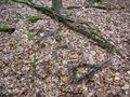
Today's location is a few metres from a forest track in the Gramschatzer Wald forest.
Country: Germany; state: Bayern (Bavaria, EU:DE:BY); administrative region: Unterfranken; district: Würzburg rural district
Weather: clouded
Expedition
Danatar
When I started out, the clouds had some dark parts, but I just hoped for the weather be stay dry and so it did. I cycled to Rimpar, where I forgot to take the field track I usually use, so I had to climb the next hill (~100 m elevation) on the country road used by many cars. I survived. Not much later I turned onto a forest track which was in surprisingly good condition and led me to the hashpoint. I took the first look at my GPS unit 500 m from the hashpoint, then cycled with the GPS unit in hand. The GPS receiver died. I stopped to take the spare batteries out of my bag, but found out that the spare batteries must habe been the ones on my kitchen table. Meh. So I took the other GPS receiver instead. After cycling a bit too far because the GPS was lagging behind, I stood on the forest track near the hashpoint. The GPS receiver told me "9 m north", I went there, it said "6 m west", I went there, it said "12 m north", I went there, it said "36 m south and 18 m east"... In short, it was the longest GPS dance I ever did, and this time it was not to get that last decimal correct but to get a picture of the unit showing me within something like 10 metres or less. The indicated distance jumped far to every side, and whenever I saw mostly correct coordinates they were gone before I could take a picture. After a while I had walked over every square metre within 20 or 25 metres of the presumed hashpoint, so I stopped this futile hunt for the GPS proof.
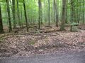
Out of the sticks that were lying around near the hashpoint I made a marker. It was the first one in a long time, due to either forgetting to make one or the place not being suited for one. Some of the sticks were so rotten that they turned to dust when I touched them. Then I cycled back. The long straight part of the country road west of the hashpoint will from now on be called "the roadkill mile": First I saw the shredded carcass of a deer in the roadside ditch. Shortly after, I saw a mole lying a few centimetres from the asphalt. I stopped and went back to it to save it from four-wheeled doom, but it was lying still and didn't move when I touched it with my foot. A more thorough examination told me it was dead :-( When I was another 200 metres down the road I saw a mouse sitting also a few centimetres from the asphalt, not moving when I rode by. Because I was in the curving part of the road I didn't stop. The rest of the way home was without other special occurrences.
When I took a shower after the expedition, I saw a black dot on my wrist. "Oh, dirt...", I thought and continued showering. shower, shower "oh, the dirt is still there, strange..." I took a closer look, and "AAAAAAH, TICK, AAAAAH, TICK, TIIIICK! badger badger badger... MUST KILL KILL KIIIIILLLLLLL!" It was sticking in my skin with its body standing away, so I could grab it with my fingernails, rip it out and drown it in the soapy shower drain. I didn't even take the time for a closer look, so I don't know which growth stage it was, the size was about 2 mm.
I cycled 15.9 + 15.2 = 31.1 km
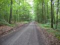
the forest track
almost there
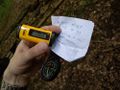
GPS
hashhog Scott in his natural habitat (i.e. at a hashpoint)

panorama
marker
this slug made 1 metre in the half hour while I was at the hashpoint
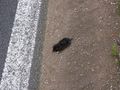
the poor mole


