Difference between revisions of "2010-06-22 40 -92"
imported>Ravi12346 (→Achievements) |
imported>FippeBot m (Location) |
||
| (7 intermediate revisions by one other user not shown) | |||
| Line 3: | Line 3: | ||
[[Image:{{{image|IMAGE}}}|thumb|left]] | [[Image:{{{image|IMAGE}}}|thumb|left]] | ||
| − | |||
--> | --> | ||
{{meetup graticule | {{meetup graticule | ||
| Line 11: | Line 10: | ||
}} | }} | ||
| − | |||
__NOTOC__ | __NOTOC__ | ||
== Location == | == Location == | ||
| − | + | A few miles southwest of Novinger, MO, at the edge of a field just off of County Road 160A. It was roughly forty meters west of a totally isolated house, and almost one meter behind a barbed wire fence with "No Trespassing" signs on it--just within reach. | |
== Participants == | == Participants == | ||
| Line 20: | Line 18: | ||
== Plans == | == Plans == | ||
| − | The morning of the hash, I noticed that the hash point was not far from Kirksville and remarkably close to the road. Since my one previous geohash attempt (and multiple planned ones) had been shot down due to distance | + | The morning of the hash, I noticed that the hash point was not far from Kirksville and remarkably close to the road. Since my one previous geohash attempt (and multiple planned ones) had been shot down due to distance from the road, I decided that this would be the perfect chance. After getting some work done in the afternoon, I grabbed a camera, a GPS, and the coordinates and enlisted my parents to come with me. |
== Expedition == | == Expedition == | ||
| − | We left home around 8:30pm, with my dad driving and me navigating. We first took Highway 6 to Novinger, then turned off onto State Highway K. (My theory: when the road changes from a number to a letter, you know you're in a rural area.) From Highway K, we turned onto the one-gravel-lane County Road 175A. (When it changes back to a number, you know you're ''really'' in a rural area.) Then we made a 150-degree left turn onto a suddenly inclined, similarly one-lane County Road 160A. (I cannot even describe how rural this place was.) The third or fourth house we passed was perhaps two [http://en.wikipedia.org/wiki/Chain_%28length%29 chains] before the hash point, which was awkwardly close for an area in which there are usually no other human beings within a quarter mile. We drove past it, then turned around to approach it from the other side. With their dog barking at us as if we were arriving in a flying saucer, I stepped out of the car, across the ditch, and up the incline to a barbed wire fence alongside the road. The hash point turned out to be just past the barbed wire--by something like a thousandth of a minute of latitude. Translation: just within arm's reach. I held the GPS over the fence and photographed it a few times. My mom joined me and took a few pictures as well, and then we took pictures of each other | + | We left home around 8:30pm, with my dad driving and me navigating. We first took Highway 6 to Novinger, then turned off onto State Highway K. (My theory: when the road changes from a number to a letter, you know you're in a rural area.) From Highway K, we turned onto the one-gravel-lane County Road 175A. (When it changes back to a number, you know you're ''really'' in a rural area.) Then we made a 150-degree left turn onto a suddenly inclined, similarly one-lane County Road 160A. (I cannot even describe how rural this place was.) The third or fourth house we passed was perhaps two [http://en.wikipedia.org/wiki/Chain_%28length%29 chains] before the hash point, which was awkwardly close for an area in which there are usually no other human beings within a quarter mile. We drove past it, then turned around to approach it from the other side. With their dog barking at us as if we were arriving in a flying saucer, I stepped out of the car, across the ditch, and up the incline to a barbed wire fence alongside the road. The hash point turned out to be just past the barbed wire--by something like a thousandth of a minute of latitude. Translation: just within arm's reach. I held the GPS over the fence and photographed it a few times. My mom joined me and took a few pictures as well, and then we took pictures of each other by our car. Since my dad remained in the car throughout, I'm not sure if I can count him as a [[Drag-along achievement]]; however, my mom did actually reach the coordinates. |
== Photos == | == Photos == | ||
| − | < | + | <gallery perrow="3"> |
| − | Image: | + | Image:2010-06-22 40 -92 gps.JPG | 42° 12.701' N, 90° 44.334' W. What you can't see is the barbed wire fence I reached over to shoot this picture. |
| − | -- | + | Image:2010-06-22 40 -92 mom.JPG | Either I'm a bad photographer or my mom is just naturally blurry. |
| − | + | Image:2010-06-22 40 -92 ravi.JPG | The hash point was in the little clear area pictured here above the GPS, a couple feet behind the faintly visible barbed wire fence. | |
</gallery> | </gallery> | ||
| Line 35: | Line 33: | ||
{{#vardefine:ribbonwidth|800px}} | {{#vardefine:ribbonwidth|800px}} | ||
<!-- Add any achievement ribbons you earned below, or remove this section --> | <!-- Add any achievement ribbons you earned below, or remove this section --> | ||
| + | {{land geohash | ||
| + | |||
| + | | latitude = 40 | ||
| + | | longitude = -92 | ||
| + | | date = 2010-06-22 | ||
| + | | name = Ravi12346 | ||
| + | |||
| + | }} | ||
{{drag-along | {{drag-along | ||
| Line 44: | Line 50: | ||
}} | }} | ||
| + | To be discussed: since the hash point was technically inside a "No Trespassing" area but I reached it without either breaking the law or receiving [[Ambassador achievement|permission]], does this qualify me for a [[No trespassing consolation prize|No trespassing]] honorable mention? | ||
| − | |||
| − | |||
[[Category:Expeditions]] | [[Category:Expeditions]] | ||
| − | |||
| − | |||
[[Category:Expeditions with photos]] | [[Category:Expeditions with photos]] | ||
| − | |||
| − | |||
| − | |||
| − | |||
[[Category:Coordinates reached]] | [[Category:Coordinates reached]] | ||
| + | {{location|US|MO|AD}} | ||
Latest revision as of 03:17, 6 August 2019
| Tue 22 Jun 2010 in 40,-92: 40.2116787, -92.7389106 geohashing.info google osm bing/os kml crox |
Location
A few miles southwest of Novinger, MO, at the edge of a field just off of County Road 160A. It was roughly forty meters west of a totally isolated house, and almost one meter behind a barbed wire fence with "No Trespassing" signs on it--just within reach.
Participants
Ravi12346 (narrator) went to the hash point with his parents.
Plans
The morning of the hash, I noticed that the hash point was not far from Kirksville and remarkably close to the road. Since my one previous geohash attempt (and multiple planned ones) had been shot down due to distance from the road, I decided that this would be the perfect chance. After getting some work done in the afternoon, I grabbed a camera, a GPS, and the coordinates and enlisted my parents to come with me.
Expedition
We left home around 8:30pm, with my dad driving and me navigating. We first took Highway 6 to Novinger, then turned off onto State Highway K. (My theory: when the road changes from a number to a letter, you know you're in a rural area.) From Highway K, we turned onto the one-gravel-lane County Road 175A. (When it changes back to a number, you know you're really in a rural area.) Then we made a 150-degree left turn onto a suddenly inclined, similarly one-lane County Road 160A. (I cannot even describe how rural this place was.) The third or fourth house we passed was perhaps two chains before the hash point, which was awkwardly close for an area in which there are usually no other human beings within a quarter mile. We drove past it, then turned around to approach it from the other side. With their dog barking at us as if we were arriving in a flying saucer, I stepped out of the car, across the ditch, and up the incline to a barbed wire fence alongside the road. The hash point turned out to be just past the barbed wire--by something like a thousandth of a minute of latitude. Translation: just within arm's reach. I held the GPS over the fence and photographed it a few times. My mom joined me and took a few pictures as well, and then we took pictures of each other by our car. Since my dad remained in the car throughout, I'm not sure if I can count him as a Drag-along achievement; however, my mom did actually reach the coordinates.
Photos
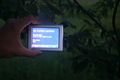
42° 12.701' N, 90° 44.334' W. What you can't see is the barbed wire fence I reached over to shoot this picture.
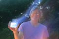
Either I'm a bad photographer or my mom is just naturally blurry.

The hash point was in the little clear area pictured here above the GPS, a couple feet behind the faintly visible barbed wire fence.


Achievements
Ravi12346 earned the Land geohash achievement
|
Ravi12346 earned the Drag-along achievement
|
To be discussed: since the hash point was technically inside a "No Trespassing" area but I reached it without either breaking the law or receiving permission, does this qualify me for a No trespassing honorable mention?