Difference between revisions of "2010-06-28 42 -72"
imported>Sara (Describing this boring suburban expedition) |
imported>FippeBot m (Location) |
||
| (One intermediate revision by one other user not shown) | |||
| Line 32: | Line 32: | ||
<gallery perrow="5"> | <gallery perrow="5"> | ||
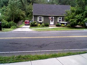
| − | Image:2010-06-28_42_-72_house.jpg | | + | Image:2010-06-28_42_-72_house.jpg | It was nice to find that the house at the hashpoint had a "Welcome" flag, like "Welcome to the hashpoint!" |
Image:2010-06-28_42_-72_marker.jpg | Behind the marker, you can see Mapleshade Elementary School. Many of the schools around here look just like Mapleshade. The banner on Mapleshade says it was built in 1955, which surprises me a little because I thought the schools that looked like that were built in the sixties. | Image:2010-06-28_42_-72_marker.jpg | Behind the marker, you can see Mapleshade Elementary School. Many of the schools around here look just like Mapleshade. The banner on Mapleshade says it was built in 1955, which surprises me a little because I thought the schools that looked like that were built in the sixties. | ||
</gallery> | </gallery> | ||
| Line 52: | Line 52: | ||
[[Category:Expedition without GPS]] | [[Category:Expedition without GPS]] | ||
[[Category:Coordinates reached]] | [[Category:Coordinates reached]] | ||
| + | {{location|US|MA|HD}} | ||
Latest revision as of 02:34, 9 August 2019
| Mon 28 Jun 2010 in 42,-72: 42.0740816, -72.5052913 geohashing.info google osm bing/os kml crox |
Location
At the side of a road in East Longmeadow, Massachusetts.
Participants
Expedition
I was supposed to be working today, but this was the perfect distance for a walk, so I took advantage of it.
I didn't bring the GPS receiver because this point was so easy to locate from Google maps and I didn't want to carry any extra weight. It was clearly directly across the street from the driveway of the brown house, which was the second house past the elementary school.
The weather wasn't too hot and the walk was pleasant, but there was nothing interesting to photograph. I don't know whether the lack of anything interesting along the route is due to my having made about 850 round trips* along most of the route to the hashpoint driving my children to and from school or whether Longmeadow and the adjacent part of East Longmeadow are simply boring.
I walked to the hashpoint, marked the point, and walked home. The entire round trip involved 15.8 km of walking and took a little over three hours.
* (That's not an English-to-metric conversion error. 850 round trips == 1700 one-way trips along that route over the five years my children have been in school. To get to my children's school, we drive almost to the hashpoint, but we make a turn just before the hashpoint and continue North for a few more miles.)
Photos
I apologize for taking pictures with a cell phone.
Achievements
Sara earned the Walk geohash Achievement
|


