Difference between revisions of "2010-07-08 33 -84"
imported>NWoodruff (Created page with '{{meetup graticule | map=<map lat="33" lon="-84" date="2010-07-08" /> | lat=33 | lon=-84 | date=2010-07-08 | graticule_name=Atlanta | graticule_link=Atlanta, Georgia }} == Grat…') |
imported>FippeBot m (Location) |
||
| (2 intermediate revisions by one other user not shown) | |||
| Line 22: | Line 22: | ||
=== [[User:NWoodruff|NWoodruff]] === | === [[User:NWoodruff|NWoodruff]] === | ||
| + | I have finally got my new eTrex setup up like I did my old one. Except this one I now have a cable that I can connect it to the cigarette lighter of my truck and not have to use battery power. | ||
| + | |||
| + | I would like to say that this geohash was a very difficult in that there were rivers to cross(the Chattahoochee), many obstacles to get around(a automobile accident on I-75 south bound in the middle lane of 8 lanes) and a fire hazard(an automobile caught fire on I-20 but was off to the side of the road). But it was very easy. | ||
| + | |||
| + | I did ride a bike from where I work to my truck parked 6 miles away, I do that every day. You can see my bicycle in the back of my truck. I did have several delays in getting to the geohash spot. | ||
| + | |||
| + | It was a very easy geohash. So easy that I didn't even have to get out of my truck to make it with in 3 feet. I did back up and go forward a few times, playing the GPS dance with my truck until I got close enough. | ||
| + | |||
| + | I took a few pictures and didn't hang around as in this abandoned section of town didn't actually look all that safe to be walking around in. I then drove home to Norcross. | ||
== Gallery == | == Gallery == | ||
<gallery perrow="3"> | <gallery perrow="3"> | ||
| − | Image:2010070833-84NW01.JPG | | + | Image:2010070833-84NW01.JPG | 2.42 feet to go. Close enough. |
| + | Image:2010070833-84NW02.JPG | Time of the meetup. | ||
| + | Image:2010070833-84NW03.JPG | Date of the meetup. | ||
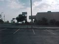
| + | Image:2010070833-84NW04.JPG | Looking north into the parking lot. | ||
| + | Image:2010070833-84NW05.JPG | The entrance sign to the abandoned hotel. | ||
| + | Image:2010070833-84NW06.JPG | Me sitting in my truck with a Stupid Grin™ | ||
</gallery> | </gallery> | ||
| Line 33: | Line 47: | ||
[[Category:Expeditions with photos]] | [[Category:Expeditions with photos]] | ||
[[Category:Coordinates reached]] | [[Category:Coordinates reached]] | ||
| + | {{location|US|GA|DA}} | ||
Latest revision as of 02:41, 9 August 2019
| Thu 8 Jul 2010 in Atlanta: 33.7129432, -84.2686770 geohashing.info google osm bing/os kml crox |
Graticule
About
In a parking lot of an abandoned hotel in East Atlanta
Expedition
NWoodruff
I have finally got my new eTrex setup up like I did my old one. Except this one I now have a cable that I can connect it to the cigarette lighter of my truck and not have to use battery power.
I would like to say that this geohash was a very difficult in that there were rivers to cross(the Chattahoochee), many obstacles to get around(a automobile accident on I-75 south bound in the middle lane of 8 lanes) and a fire hazard(an automobile caught fire on I-20 but was off to the side of the road). But it was very easy.
I did ride a bike from where I work to my truck parked 6 miles away, I do that every day. You can see my bicycle in the back of my truck. I did have several delays in getting to the geohash spot.
It was a very easy geohash. So easy that I didn't even have to get out of my truck to make it with in 3 feet. I did back up and go forward a few times, playing the GPS dance with my truck until I got close enough.
I took a few pictures and didn't hang around as in this abandoned section of town didn't actually look all that safe to be walking around in. I then drove home to Norcross.
Gallery
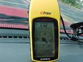
2.42 feet to go. Close enough.
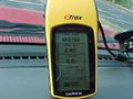
Time of the meetup.
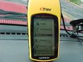
Date of the meetup.
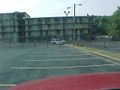
Looking north into the parking lot.
The entrance sign to the abandoned hotel.
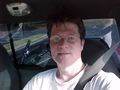
Me sitting in my truck with a Stupid Grin™


