Difference between revisions of "2010-07-15 60 25"
imported>Kmk (→Location) |
imported>FippeBot m (Location) |
||
| (5 intermediate revisions by one other user not shown) | |||
| Line 1: | Line 1: | ||
| − | |||
<!-- If you did not specify these parameters in the template, please substitute appropriate things for IMAGE, LAT, LON, and DATE (YYYY-MM-DD format) | <!-- If you did not specify these parameters in the template, please substitute appropriate things for IMAGE, LAT, LON, and DATE (YYYY-MM-DD format) | ||
| Line 16: | Line 15: | ||
== Location == | == Location == | ||
<!-- where you've surveyed the hash to be --> | <!-- where you've surveyed the hash to be --> | ||
| − | + | Next to an easily accessible road that also has a popular cycling section. The hash itself appeared to be in a forest about 30 meters from the road. | |
== Participants == | == Participants == | ||
| + | [[User:Kmk|Kmk]] | ||
<!-- who attended --> | <!-- who attended --> | ||
== Plans == | == Plans == | ||
| − | + | The hash was at a very cyclable location, so a perfect way to spend a holiday afternoon was to actually visit my my first geohash. The plan was to leisurely cycle on the Vanha Tuusulantie and keep checking on Geohash Droid when I'm near. | |
== Expedition == | == Expedition == | ||
| − | + | Pretty much as planned. It was hotter, though, and more uphills and downhills than expected. For some reason the side of the road next to the hash had about four cars parked there. Not surprisingly, none of them were geohashers but apparently visitors to a nearby house. | |
| − | + | Surprisingly, there was a path in the forest suitable for parking the cycle 30 meters from the hash. Even more surprisingly, there was another path 30 meters north, passing directly through the hashpoint. The thrill of actually reaching a geohash was something rather unexpected! | |
| − | + | ||
| + | I walked around the area a bit, took some photographs and returned home right before the thunderstorm. | ||
== Photos == | == Photos == | ||
| − | < | + | <gallery> |
| − | Image: | + | Image:2010-07-15_60_25_grin.jpg | Stupid grin |
| − | -- | + | Image:2010-07-15_60_25_path.jpg | The path on which the hash is |
| − | + | Image:2010-07-15_60_25_easy.jpg | The easy path from road to the hash | |
| + | Image:2010-07-15_60_25_chosen.jpg | The chosen path from road to the hash | ||
</gallery> | </gallery> | ||
| − | |||
| − | |||
| − | |||
| − | |||
| − | |||
| − | |||
| − | |||
| − | |||
| − | |||
| − | |||
| − | |||
| − | |||
| − | |||
| − | |||
| − | |||
[[Category:Expeditions]] | [[Category:Expeditions]] | ||
| − | |||
[[Category:Expeditions with photos]] | [[Category:Expeditions with photos]] | ||
| − | |||
| − | |||
| − | |||
| − | |||
| − | |||
[[Category:Coordinates reached]] | [[Category:Coordinates reached]] | ||
| − | + | {{location|FI|18}} | |
| − | |||
| − | |||
| − | |||
| − | |||
| − | |||
| − | |||
| − | |||
| − | |||
| − | |||
Latest revision as of 02:48, 9 August 2019
| Thu 15 Jul 2010 in 60,25: 60.3585818, 25.0108471 geohashing.info google osm bing/os kml crox |
Location
Next to an easily accessible road that also has a popular cycling section. The hash itself appeared to be in a forest about 30 meters from the road.
Participants
Plans
The hash was at a very cyclable location, so a perfect way to spend a holiday afternoon was to actually visit my my first geohash. The plan was to leisurely cycle on the Vanha Tuusulantie and keep checking on Geohash Droid when I'm near.
Expedition
Pretty much as planned. It was hotter, though, and more uphills and downhills than expected. For some reason the side of the road next to the hash had about four cars parked there. Not surprisingly, none of them were geohashers but apparently visitors to a nearby house.
Surprisingly, there was a path in the forest suitable for parking the cycle 30 meters from the hash. Even more surprisingly, there was another path 30 meters north, passing directly through the hashpoint. The thrill of actually reaching a geohash was something rather unexpected!
I walked around the area a bit, took some photographs and returned home right before the thunderstorm.
Photos

Stupid grin
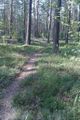
The path on which the hash is
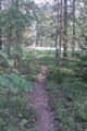
The easy path from road to the hash
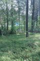
The chosen path from road to the hash


