Difference between revisions of "2010-07-16 39 -84"
imported>Hounddog |
imported>FippeBot m (Location) |
||
| (3 intermediate revisions by 2 users not shown) | |||
| Line 1: | Line 1: | ||
| − | |||
| − | |||
| − | |||
| − | |||
| − | |||
| − | |||
| − | |||
{{meetup graticule | {{meetup graticule | ||
| lat=39 | | lat=39 | ||
| Line 45: | Line 38: | ||
--> | --> | ||
<gallery perrow="5"> | <gallery perrow="5"> | ||
| + | Image:2010-07-16_39_-84_GPS.jpg | GPS | ||
| + | Image:2010-07-16_39_-84_Hounddog_and_coworkers.jpg | Us | ||
| + | Image:2010-07-16_39_-84_Small_Hill.jpg | Behind the hash | ||
| + | Image:2010-07-16_39_-84_field.jpg | The hash | ||
</gallery> | </gallery> | ||
| Line 50: | Line 47: | ||
{{#vardefine:ribbonwidth|800px}} | {{#vardefine:ribbonwidth|800px}} | ||
<!-- Add any achievement ribbons you earned below, or remove this section --> | <!-- Add any achievement ribbons you earned below, or remove this section --> | ||
| + | {{land geohash | ||
| + | | latitude = 39 | ||
| + | | longitude = -84 | ||
| + | | date = 2010-07-16 | ||
| + | | name = [[User:Hounddog | Hounddog]] | ||
| + | | image = 2010-07-16_39_-84_Hounddog_and_coworkers.jpg | ||
| + | }} | ||
| − | |||
| − | |||
| − | |||
| − | + | [[Category:Expeditions]] | |
| − | |||
| − | [[Category: | ||
| − | |||
| − | |||
| − | |||
| − | |||
[[Category:Expeditions with photos]] | [[Category:Expeditions with photos]] | ||
| − | + | ||
| − | |||
| − | |||
| − | |||
| − | |||
[[Category:Coordinates reached]] | [[Category:Coordinates reached]] | ||
| − | + | {{location|US|OH|WR}} | |
| − | |||
| − | |||
| − | |||
| − | |||
| − | |||
| − | |||
| − | |||
| − | |||
| − | |||
Latest revision as of 02:48, 9 August 2019
| Fri 16 Jul 2010 in Cincinnati: 39.5731138, -84.1707132 geohashing.info google osm bing/os kml crox |
Location
Behind a new housing development, on the edge of some unmarked farm.
Participants
Hounddog, and two of his co-workers (Who for now shall remain nameless)
Plans
Well, I've (Hounddog) been waiting for one of these to pop near the Dayton area for a while now, so I could go on my first hash. As it just so happened, today's was very close to my office! So, I convinced two of my coworkers to go along with me and discover the hash on our lunch break (12:00-13:00)
Expedition
Well, as 12:00 rolled around, we all piled into one of my coworkers car (he had the GPS), and drove close to the hash point. Apparently, what was an empty lot on Google Maps is now the beginning of a housing development! Fortunately, the hash was past the development not inside of it. Unfortunately, we had to avoid maneuver around a new lake that was created, as well as go out of our way to avoid the construction crews.
The other additional hazard was even worse...a small creek. See, while two of us were easily able to jump the water, the other one had fractured his leg in a skydiving crash, and was currently wearing a boot. So, we had to go exploring through the high grass and weeks and pricker bushes until we could find a spot narrow enough to step across.
Eventually we made it across. We got as close as we could to the hash point...we were probably 4 or 5 feet from it (we were using a car GPS, so who knows how accurate those things are), but there was a field of what looked to be some kind of crop in our way. So rather than wade through it, we called 4 or 5 feet away to be "good enough." We then made our way back across the creek, around the pond, picked up some Taco Bell, then went back to work.
Photos
GPS
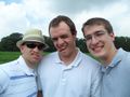
Us
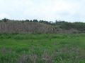
Behind the hash
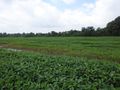
The hash


Achievements
Hounddog earned the Land geohash achievement
|