Difference between revisions of "2010-07-20 50 11"
imported>Reinhard (Created page with '{{subst:Expedition |lat = 50 |lon = 11 |date = 2010-07-20 }}') |
imported>FippeBot m (Location) |
||
| (3 intermediate revisions by one other user not shown) | |||
| Line 1: | Line 1: | ||
| − | |||
| − | |||
| − | |||
| − | |||
| − | |||
| − | |||
| − | |||
{{meetup graticule | {{meetup graticule | ||
| lat=50 | | lat=50 | ||
| Line 15: | Line 8: | ||
__NOTOC__ | __NOTOC__ | ||
== Location == | == Location == | ||
| − | + | In the forest near Hermsdorf. | |
== Participants == | == Participants == | ||
| − | + | * [[user:Reinhard|Reinhard]] | |
| − | |||
| − | |||
| − | |||
== Expedition == | == Expedition == | ||
| − | + | After work I felt like having a nice bike trip while the sun was setting. The 50 11 hashpoint was conveniently close and looked reachable in a forest not too far from paths and roads. By taking some smaller detours I reached the hashpoint area around 20:15. First, I had to use a gravel path through the forest for some hundred meters, then I was continuing on a smaller path for few meters. When I got closer to the spot I saw that there was a fenced area (rather for animal or plant protection than because of private property) which seemed to include the exact coordinates. I stepped right beside the fence and was still 17 m away. Then I walked around one edge of the fenced area and along the other side and suddenly the position marker on the display of my GPS device drifted towards the hash marker. I quickly took a photo, when the distance was only 7 m and the hash marker within the circle of GPS accuracy, and continued watching the drifting arrow. It didn't get closer, but due to this within-10-m rule I think, I can take this hashpoint as being reached. When I turned around to get back to my bike, I saw that I was standing in blueberry bushes and ate three or four delicious berries. Then I cycled back to Jena, ending the trip after 77 km shortly after the sun had set. | |
| − | |||
| − | |||
| − | |||
== Photos == | == Photos == | ||
| − | + | {{gallery|width=200|height=200|lines=3 | |
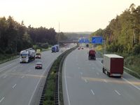
| − | Image: | + | |Image:20100720-50N11E-01.jpg|Crossing motorway A9 close to the hashpoint. |
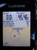
| − | -- | + | |Image:20100720-50N11E-02.jpg|Think, I can't get closer ... |
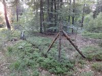
| − | + | |Image:20100720-50N11E-03.jpg|... due to this fence | |
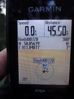
| − | + | |Image:20100720-50N11E-04.jpg|At the other edge of the fence I could at least come closer as GPS accuracy to the hashpoint. | |
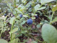
| + | |Image:20100720-50N11E-05.jpg|Delicious blueberries. | ||
| + | }} | ||
| − | |||
| − | |||
| − | |||
| − | |||
| − | |||
| − | |||
| − | |||
| − | |||
| − | |||
| − | |||
| − | |||
| − | |||
| − | |||
| − | |||
[[Category:Expeditions]] | [[Category:Expeditions]] | ||
| − | |||
[[Category:Expeditions with photos]] | [[Category:Expeditions with photos]] | ||
| − | |||
| − | |||
| − | |||
| − | |||
| − | |||
[[Category:Coordinates reached]] | [[Category:Coordinates reached]] | ||
| − | + | {{location|DE|TH|SHK}} | |
| − | |||
| − | |||
| − | |||
| − | |||
| − | |||
| − | |||
| − | |||
| − | |||
| − | |||
Latest revision as of 02:53, 9 August 2019
| Tue 20 Jul 2010 in 50,11: 50.8567894, 11.8487759 geohashing.info google osm bing/os kml crox |
Location
In the forest near Hermsdorf.
Participants
Expedition
After work I felt like having a nice bike trip while the sun was setting. The 50 11 hashpoint was conveniently close and looked reachable in a forest not too far from paths and roads. By taking some smaller detours I reached the hashpoint area around 20:15. First, I had to use a gravel path through the forest for some hundred meters, then I was continuing on a smaller path for few meters. When I got closer to the spot I saw that there was a fenced area (rather for animal or plant protection than because of private property) which seemed to include the exact coordinates. I stepped right beside the fence and was still 17 m away. Then I walked around one edge of the fenced area and along the other side and suddenly the position marker on the display of my GPS device drifted towards the hash marker. I quickly took a photo, when the distance was only 7 m and the hash marker within the circle of GPS accuracy, and continued watching the drifting arrow. It didn't get closer, but due to this within-10-m rule I think, I can take this hashpoint as being reached. When I turned around to get back to my bike, I saw that I was standing in blueberry bushes and ate three or four delicious berries. Then I cycled back to Jena, ending the trip after 77 km shortly after the sun had set.
Photos
|
