Difference between revisions of "2010-08-11 40 -104"
From Geohashing
imported>Hoozer (Created page with '__NOTOC__ {{meetup graticule | map=<map lat="40" lon="-104" date="2010-08-11" /> | lat=40 | lon=-104 | date=2010-08-11 }} == About == The NE Denver geohash …') |
imported>FippeBot m (Location) |
||
| (4 intermediate revisions by one other user not shown) | |||
| Line 6: | Line 6: | ||
| date=2010-08-11 | | date=2010-08-11 | ||
}} | }} | ||
| − | == | + | == Location == |
| − | + | 9 miles (14.5 km) west of Briggsdale, CO in the Pawnee National Grassland. | |
== Expedition == | == Expedition == | ||
| Line 20: | Line 20: | ||
==Stats== | ==Stats== | ||
| − | Walking distance: 1 mile (1.6 km) | + | Walking distance: 1 mile (1.6 km)<br> |
Cows disturbed: 1 herd | Cows disturbed: 1 herd | ||
| Line 26: | Line 26: | ||
<gallery widths="100px" align=center> | <gallery widths="100px" align=center> | ||
| − | Image: | + | Image:Landgeohash.png|[[Land Geohash]] |
</gallery> | </gallery> | ||
| Line 39: | Line 39: | ||
[[Category:Expeditions with photos]] | [[Category:Expeditions with photos]] | ||
[[Category:Coordinates reached]] | [[Category:Coordinates reached]] | ||
| + | {{location|US|CO|WE}} | ||
Latest revision as of 03:14, 9 August 2019
| Wed 11 Aug 2010 in 40,-104: 40.6447452, -104.4959492 geohashing.info google osm bing/os kml crox |
Location
9 miles (14.5 km) west of Briggsdale, CO in the Pawnee National Grassland.
Expedition
Hoozer was working near the hashpoint that day, and decided to attempt to reach the hashpoint on his way back home that afternoon. He parked due east of the hashpoint and walked to the hashpoint.
Participants
Stats
Walking distance: 1 mile (1.6 km)
Cows disturbed: 1 herd
Achievements

Pictures
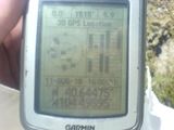
GPS screenshot.
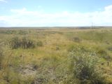
View of the prairie from the hashpoint.

