Difference between revisions of "2010-08-28 46 -123"
imported>Michael5000 (→Achievements) |
m (per Renaming Proposal) |
||
| (4 intermediate revisions by 3 users not shown) | |||
| Line 1: | Line 1: | ||
| − | + | [[File:2010-08-28 46 -123.JPG|thumb|left|250px|The little creek at the bottom of the canyon.]] | |
| − | |||
| − | |||
| − | |||
| − | |||
| − | |||
| − | |||
| − | |||
{{meetup graticule | {{meetup graticule | ||
| Line 19: | Line 12: | ||
== Location == | == Location == | ||
| − | + | In Clatsop State Forest, roughly 10 miles west of Clatskanie, Oregon. | |
== Participants == | == Participants == | ||
| Line 32: | Line 25: | ||
== Photos == | == Photos == | ||
| − | |||
| − | |||
| − | |||
<gallery perrow="5"> | <gallery perrow="5"> | ||
| + | File:2010-08-28 46 -123 signage.JPG|The sign where the side road left the main highway. | ||
| + | File:2010-08-28 46 -123 bike setup.JPG|The triathlon setup -- hashscot and GPS gadget travel in the bicycle map carrier. | ||
| + | File:2010-08-28 46 -123.JPG|The creek at the bottom of the canyon provided the only easy route to walk on. | ||
| + | File:2010-08-28 46 -123 Landscape.JPG|Blurry picture of what the canyon landscape looks like. It's dark down there. | ||
| + | File:2010-08-28 46 -123 Hashpoint.JPG|At the Hashpoint. | ||
| + | File:2010-08-28 46 -123 legs.JPG|My forest-ravaged legs in the aftermath. | ||
| + | File:2010-08-28 46 -123 Scenic View.JPG|A view of the Columbia Valley from a side trail off of the quarry road. | ||
</gallery> | </gallery> | ||
| Line 41: | Line 38: | ||
{{#vardefine:ribbonwidth|800px}} | {{#vardefine:ribbonwidth|800px}} | ||
| − | {{ | + | {{one with nature |
| latitude = 46 | | latitude = 46 | ||
| longitude = -123 | | longitude = -123 | ||
| Line 52: | Line 49: | ||
{{Multihash2 | count = 3 | date = 2010-08-28 | name = Michael5000}} | {{Multihash2 | count = 3 | date = 2010-08-28 | name = Michael5000}} | ||
| − | |||
[[Category:Expeditions]] | [[Category:Expeditions]] | ||
[[Category:Expeditions with photos]] | [[Category:Expeditions with photos]] | ||
[[Category:Coordinates reached]] | [[Category:Coordinates reached]] | ||
| + | {{location|US|OR|CT}} | ||
Latest revision as of 14:40, 2 April 2024

| Sat 28 Aug 2010 in 46,-123: 46.1499209, -123.4496031 geohashing.info google osm bing/os kml crox |
Location
In Clatsop State Forest, roughly 10 miles west of Clatskanie, Oregon.
Participants
Expedition
I parked just off of US30 on a gravel road, and took the bicycle up about two miles past a couple of quarry operations. And when I say "up," I mean that the ride was steeply uphill, and that after having departed from a point where highway thirty leaves the valley of the Columbia to climb over a high ridge. So, what I expected would be a hashpoint in a slight draw by a creek turned out to be a hashpoint in a deep, heavily wooded canyon.
That should have been the end of the story, except that I'm stupid. There was nothing resembling a trail, so I just clung to the idea that "if you can get DOWN it, you can usually get back UP it," and began a long descent into the ravine. This is classic rainforest country, so I was immediately in a dim twilight with poor footing, brambles, logs fallen and rotting every which way, and, of course, a 45+ degree slope. Because the hashpoint was itself basically on the face of a cliff, and because the GPS unit had trouble keeping in touch with the satellites through all that forest canopy, it was not an easy point to zero in on. It was only 400 feet from the road to the hashpoint, but I was in the canyon at least 45 minutes, and emerged filthy, drenched with sweat, and with a pretty good set of bleeding lacerations on my legs and arms. But also triumphant.
Photos
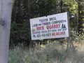
The sign where the side road left the main highway.
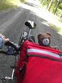
The triathlon setup -- hashscot and GPS gadget travel in the bicycle map carrier.
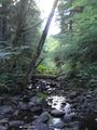
The creek at the bottom of the canyon provided the only easy route to walk on.
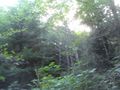
Blurry picture of what the canyon landscape looks like. It's dark down there.
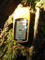
At the Hashpoint.
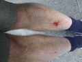
My forest-ravaged legs in the aftermath.
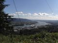
A view of the Columbia Valley from a side trail off of the quarry road.


Achievements
Michael5000 earned the One with Nature Geohash Achievement
|
Well, I don't know if Mother Nature is REALLY my bitch per se, but it sure felt like it when I scrambled back up onto the road.
Michael5000 earned the Multihash Achievement
|