Difference between revisions of "2010-09-04 52 5"
imported>Antior (Created page with '{{subst:Expedition |lat = 52 |lon = 5 |date = 2010-09-04 }}') |
imported>FippeBot m (Location) |
||
| (13 intermediate revisions by 5 users not shown) | |||
| Line 1: | Line 1: | ||
| + | [[Image:2010-09-04_52_5_Overview_North.jpg|Hashpoint reached|thumb|left]] | ||
| − | |||
| − | |||
| − | |||
| − | |||
| − | |||
| − | |||
| − | |||
| − | |||
| − | |||
{{meetup graticule | {{meetup graticule | ||
| lat=52 | | lat=52 | ||
| Line 15: | Line 7: | ||
}} | }} | ||
| − | |||
__NOTOC__ | __NOTOC__ | ||
== Location == | == Location == | ||
| − | + | In between Montfoort en IJsselstein, in a piece of farmland, probably privately owned. | |
| + | |||
| + | |||
| + | |||
| + | |||
| + | |||
== Participants == | == Participants == | ||
| − | + | * [[User:CO2|CO2]] | |
| + | * [[User:Freeze_XJ|Freeze_XJ]] | ||
== Plans == | == Plans == | ||
| − | + | We're going to go there by bike. We'll see what we do when we get there. If we can't just get on there we might try Ambassador. | |
== Expedition == | == Expedition == | ||
| − | + | After a somewhat delayed start (blame Freeze_XJs job) we mounted our bikes at 4 pm, heading towards the Dom tower (quite central in Utrecht), through the current sand pit called Central Station, and further east, to cross the great wide Amsterdam Rhine Canal. Using the map every now and then, we got blocked by the A12 highway. 2 friendly guys told us to simply cross the park, and then we would be able to pass this obstacle, which we did, after an odd bike ride through said park. | |
| + | |||
| + | From there on, the road was simple, going south, and following the cyclists routes we crossed the Hollandse IJssel (not to be confused with the other IJssel, which runs far further east, and is bigger too). The hash point, as expected, lay in the middle of a field, and was unreachable, pretty much shielded by "No entrance" signs. After cycling around a bit, we asked the guy from the farm behind it (long live Google Earth for scouting areas), and after a small explanation of what geohashing was, and what 2 weirdos would do to his land (just take pictures, no harm), he had no objection to us ignoring the signs. | ||
| + | |||
| + | Jumping the fence (it was locked tight), we walked to the hash point, made the obligatory pictures (with the Cabauw/Lopik radio tower in the background), and left the hay field. | ||
| + | |||
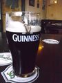
| + | The return was supposed to be simple, except that I (Freeze) took a wrong turn, so we ended up in the middle of an odd festival, that sounded so bad that we sort of ran from it. Straying once more from the planned route to end up in an Irish pub, we called it a success, looking over a solid pint of Guinness :) | ||
| − | |||
| − | |||
== Photos == | == Photos == | ||
| − | |||
| − | |||
| − | |||
<gallery perrow="5"> | <gallery perrow="5"> | ||
| + | Image:2010-09-04_52_5_lake.jpg | A lake we came by along the way | ||
| + | Image:2010-09-04_52_5_IJsselview.jpg | View along the river | ||
| + | Image:2010-09-05_52_5_ijssel2.jpg | Other side of the river | ||
| + | Image:2010-09-04_52_5_Route.jpg | How hard can it be? | ||
| + | Image:2010-09-04_52_5_Overview_North.jpg | Should be about here... | ||
| + | Image:2010-09-04_52_5_Hash.jpg | Hayhay, #. reached! | ||
| + | Image:2010-09-04_52_5_not-so-wild-life.jpg | Local not-so-wild-life at the hashpoint | ||
| + | Image:2010-09-04_52_5_Aftermath.jpg | Cheers! | ||
| + | Image:2010-09-4_52_5_pint.jpg | Bestest way to end the day :) | ||
</gallery> | </gallery> | ||
== Achievements == | == Achievements == | ||
{{#vardefine:ribbonwidth|800px}} | {{#vardefine:ribbonwidth|800px}} | ||
| − | + | {{Ambassador geohash | latitude = 52 | longitude = 5 | date = 2010-09-04 | granter = the farmer | name = [[User:CO2|CO2]] and [[User:Freeze_XJ|Freeze]] | image = 2010-09-04_52_5_NoEntry.jpg }} | |
| − | |||
| − | |||
| − | |||
| − | |||
| − | |||
| − | |||
| − | |||
| − | |||
| − | |||
| − | |||
| − | |||
[[Category:Expeditions]] | [[Category:Expeditions]] | ||
| − | |||
[[Category:Expeditions with photos]] | [[Category:Expeditions with photos]] | ||
| − | |||
[[Category:Expedition without GPS]] | [[Category:Expedition without GPS]] | ||
| − | |||
| − | |||
| − | |||
[[Category:Coordinates reached]] | [[Category:Coordinates reached]] | ||
| − | + | {{location|NL|UT}} | |
| − | |||
| − | |||
| − | |||
| − | |||
| − | |||
| − | |||
| − | |||
| − | |||
| − | |||
Latest revision as of 03:35, 9 August 2019

| Sat 4 Sep 2010 in 52,5: 52.0448326, 5.0126721 geohashing.info google osm bing/os kml crox |
Location
In between Montfoort en IJsselstein, in a piece of farmland, probably privately owned.
Participants
Plans
We're going to go there by bike. We'll see what we do when we get there. If we can't just get on there we might try Ambassador.
Expedition
After a somewhat delayed start (blame Freeze_XJs job) we mounted our bikes at 4 pm, heading towards the Dom tower (quite central in Utrecht), through the current sand pit called Central Station, and further east, to cross the great wide Amsterdam Rhine Canal. Using the map every now and then, we got blocked by the A12 highway. 2 friendly guys told us to simply cross the park, and then we would be able to pass this obstacle, which we did, after an odd bike ride through said park.
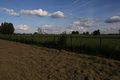
From there on, the road was simple, going south, and following the cyclists routes we crossed the Hollandse IJssel (not to be confused with the other IJssel, which runs far further east, and is bigger too). The hash point, as expected, lay in the middle of a field, and was unreachable, pretty much shielded by "No entrance" signs. After cycling around a bit, we asked the guy from the farm behind it (long live Google Earth for scouting areas), and after a small explanation of what geohashing was, and what 2 weirdos would do to his land (just take pictures, no harm), he had no objection to us ignoring the signs.
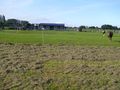
Jumping the fence (it was locked tight), we walked to the hash point, made the obligatory pictures (with the Cabauw/Lopik radio tower in the background), and left the hay field.
The return was supposed to be simple, except that I (Freeze) took a wrong turn, so we ended up in the middle of an odd festival, that sounded so bad that we sort of ran from it. Straying once more from the planned route to end up in an Irish pub, we called it a success, looking over a solid pint of Guinness :)
Photos
A lake we came by along the way
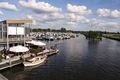
View along the river
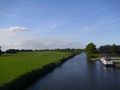
Other side of the river
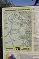
How hard can it be?
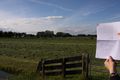
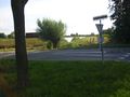
Should be about here...
Hayhay, #. reached!
Local not-so-wild-life at the hashpoint
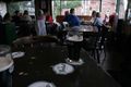
Cheers!
Bestest way to end the day :)


Achievements
CO2 and Freeze earned the Ambassador achievement
|