Difference between revisions of "2010-09-06 44 -93"
imported>Dvdllr (Created page with '{{subst:Expedition |lat = 44 |lon = -93 |date = 2010-09-06 }}') |
imported>FippeBot m (Location) |
||
| (3 intermediate revisions by one other user not shown) | |||
| Line 1: | Line 1: | ||
| − | + | __NOTOC__ | |
| − | |||
| − | |||
| − | |||
| − | |||
| − | |||
| − | |||
| − | |||
| − | |||
| − | |||
{{meetup graticule | {{meetup graticule | ||
| lat=44 | | lat=44 | ||
| Line 14: | Line 5: | ||
| date=2010-09-06 | | date=2010-09-06 | ||
}} | }} | ||
| − | |||
| − | |||
| − | |||
== Location == | == Location == | ||
| − | + | Grounds of some apartment buildings in Waseca, Minnesota. | |
== Participants == | == Participants == | ||
| − | + | * [[User:Dvdllr|Dvdllr]] | |
| + | * Dvdllr's dad | ||
== Plans == | == Plans == | ||
| − | + | The three day weekend afforded me the opportunity to review the location of four day's geohashes on Friday morning. And, in traveling to the Twin Cities for the holiday, I spent some time reviewing the location not only for [[Peoria, Illinois|Peoria]] but also for each graticule I'd hit while going there and back again. This was one that wasn't terribly far off of I-35, making it a candidate for a stop-by on the way back home. I just needed to convince the driver (my dad) to make the detour, which wasn't difficult. | |
== Expedition == | == Expedition == | ||
| − | + | My family's vacation in Bloomington, Minnesota ended on Labor Day, and travelling in the car was my wife and I along with my parents, as we had been visiting my brother. On the way back home, the men both were interested in Geohashing (my dad has wanted to before, but the only time I took him out with me before, we forgot to bring a camera along so we abandoned it). An extra thirty minutes to our trip was all it took. The satellite view showed buildings and a parking lot, but Google e.g. didn't tell me what the buildings were. Upon arrival, we found them to be apartments. This revelation made the women decide they didn't want to go out, since (at least speaking for my wife) they didn't want a confrontation from a renter wondering what we were doing. Dad and I wandered around the parking lot and a portion of the lawn trying to get the Nüvi to line up its coordinates as best as we could. Our results were fairly typical. The GPS kept drifting our position south, though the satellite view clearly showed the pin in the parking lot, so we made a best guess and planted the flag at the edge of the lot. | |
| − | + | == Photos == | |
| − | |||
| − | |||
| − | == Photos == | ||
| − | |||
| − | |||
| − | |||
<gallery perrow="5"> | <gallery perrow="5"> | ||
| + | Image:2010-09-06 44 -93 1.jpg | The apartment complex | ||
| + | Image:2010-09-06 44 -93 2.jpg | Coordinates | ||
| + | Image:2010-09-06 44 -93 3.jpg | Father and son | ||
| + | Image:2010-09-06 44 -93 4.jpg | Somewhere in the vicinity | ||
| + | Image:2010-09-06 44 -93 5.jpg | Geohashing widows | ||
</gallery> | </gallery> | ||
== Achievements == | == Achievements == | ||
{{#vardefine:ribbonwidth|800px}} | {{#vardefine:ribbonwidth|800px}} | ||
| − | + | {{land geohash | |
| + | | latitude = 44 | ||
| + | | longitude = -93 | ||
| + | | date = 2010-09-06 | ||
| + | | name = [[User:Dvdllr|Dvdllr]] | ||
| + | }} | ||
| + | {{A Tale of Two Hashes challenge | ||
| + | | latitude = 44 | ||
| + | | longitude = -93 | ||
| + | | date = 2010-09-06 | ||
| + | | name = [[User:Dvdllr|Dvdllr]] | ||
| + | | place = [http://en.wikipedia.org/wiki/Parkview Parkview] | ||
| + | }} | ||
| + | {{drag-along | ||
| − | + | | latitude = 44 | |
| − | + | | longitude = -93 | |
| − | [[ | + | | date = 2010-09-06 |
| + | | partner = his dad | ||
| + | | name = [[User:Dvdllr|Dvdllr]] | ||
| + | }} | ||
| − | |||
| − | |||
| − | |||
| − | |||
| − | |||
[[Category:Expeditions]] | [[Category:Expeditions]] | ||
| − | |||
[[Category:Expeditions with photos]] | [[Category:Expeditions with photos]] | ||
| − | |||
| − | |||
| − | |||
| − | |||
| − | |||
[[Category:Coordinates reached]] | [[Category:Coordinates reached]] | ||
| − | + | {{location|US|MN|WE}} | |
| − | |||
| − | |||
| − | |||
| − | |||
| − | |||
| − | |||
| − | |||
| − | |||
| − | |||
Latest revision as of 03:31, 6 August 2019
| Mon 6 Sep 2010 in 44,-93: 44.0692489, -93.5129623 geohashing.info google osm bing/os kml crox |
Location
Grounds of some apartment buildings in Waseca, Minnesota.
Participants
- Dvdllr
- Dvdllr's dad
Plans
The three day weekend afforded me the opportunity to review the location of four day's geohashes on Friday morning. And, in traveling to the Twin Cities for the holiday, I spent some time reviewing the location not only for Peoria but also for each graticule I'd hit while going there and back again. This was one that wasn't terribly far off of I-35, making it a candidate for a stop-by on the way back home. I just needed to convince the driver (my dad) to make the detour, which wasn't difficult.
Expedition
My family's vacation in Bloomington, Minnesota ended on Labor Day, and travelling in the car was my wife and I along with my parents, as we had been visiting my brother. On the way back home, the men both were interested in Geohashing (my dad has wanted to before, but the only time I took him out with me before, we forgot to bring a camera along so we abandoned it). An extra thirty minutes to our trip was all it took. The satellite view showed buildings and a parking lot, but Google e.g. didn't tell me what the buildings were. Upon arrival, we found them to be apartments. This revelation made the women decide they didn't want to go out, since (at least speaking for my wife) they didn't want a confrontation from a renter wondering what we were doing. Dad and I wandered around the parking lot and a portion of the lawn trying to get the Nüvi to line up its coordinates as best as we could. Our results were fairly typical. The GPS kept drifting our position south, though the satellite view clearly showed the pin in the parking lot, so we made a best guess and planted the flag at the edge of the lot.
Photos

The apartment complex
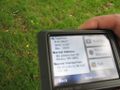
Coordinates

Father and son
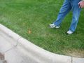
Somewhere in the vicinity
Geohashing widows


Achievements
Dvdllr earned the Land geohash achievement
|
Dvdllr issued a challenge for the Tale of Two Hashes achievement
|
Dvdllr earned the Drag-along achievement
|