Difference between revisions of "2010-10-16 45 -123"
imported>Redaragorn (→Photos) |
imported>FippeBot m (Location) |
||
| (4 intermediate revisions by 2 users not shown) | |||
| Line 16: | Line 16: | ||
__NOTOC__ | __NOTOC__ | ||
== Location == | == Location == | ||
| − | + | ||
Just off a road not far inland from the town of Nehalem. | Just off a road not far inland from the town of Nehalem. | ||
== Participants == | == Participants == | ||
| − | + | ||
* [[User:Redaragorn|redaragorn]] | * [[User:Redaragorn|redaragorn]] | ||
== Plans == | == Plans == | ||
| − | + | ||
I was already planning on heading out to the beach with the family for the day, so it didn't seem like too much of a stretch to head in a short distance to catch the hash. I figure the timing will be a little tricky because we are heading out with the in-laws, but I imagine that I'll leave all the family at a nearby beach and go find the hash on my own. | I was already planning on heading out to the beach with the family for the day, so it didn't seem like too much of a stretch to head in a short distance to catch the hash. I figure the timing will be a little tricky because we are heading out with the in-laws, but I imagine that I'll leave all the family at a nearby beach and go find the hash on my own. | ||
== Expedition == | == Expedition == | ||
| − | + | ||
| + | Did end up leaving the family at the (rather chilly and windy) beach for an hour or so. I drove up from Rockaway Beach and inland from there to the small road where the hash was located. I ended up missing the pullout close to the hash, but I quickly realized and turned around to go back to the spot. | ||
| + | |||
| + | I got out and started walking around to try to find the exact hashpoint. I started down the steep bank with the ferns and the blackberry bushes when I realized that my GPS was kind of wigging out. I guess that I wasn't getting any much closer to the hash (as measured by distance to the point), despite the fact that I was heading in the direction it told me I should be going. My best guess is that my signal wasn't so strong in the fairly narrow, heavily forested valley. | ||
| + | |||
| + | I ended up getting under 10' to the hash, although the point was across the road from where it looked like the hash was on the satellite map. Oh well. I got my requisite pics and headed back to meet the family. Mission accomplished. | ||
== Tracklog == | == Tracklog == | ||
| − | + | ||
The track can be found [http://www.trailguru.com/wiki/index.php/Track:EJ8N?units=imperial here]. | The track can be found [http://www.trailguru.com/wiki/index.php/Track:EJ8N?units=imperial here]. | ||
== Photos == | == Photos == | ||
| − | |||
| − | |||
<gallery perrow="5"> | <gallery perrow="5"> | ||
Image:2010-10-16 45 -123 - GPS.jpg | GPS coordinates | Image:2010-10-16 45 -123 - GPS.jpg | GPS coordinates | ||
| Line 47: | Line 50: | ||
== Achievements == | == Achievements == | ||
{{#vardefine:ribbonwidth|800px}} | {{#vardefine:ribbonwidth|800px}} | ||
| − | |||
| + | * Land Geohash | ||
| − | |||
| − | |||
| − | |||
| − | |||
| + | [[Category:Expeditions]] | ||
| − | |||
| − | |||
| − | |||
[[Category:Expeditions with photos]] | [[Category:Expeditions with photos]] | ||
| − | |||
| − | |||
| − | |||
| − | |||
| − | |||
[[Category:Coordinates reached]] | [[Category:Coordinates reached]] | ||
| − | + | {{location|US|OR|TI}} | |
| − | |||
| − | |||
| − | |||
| − | |||
| − | |||
| − | |||
| − | |||
| − | |||
| − | |||
Latest revision as of 04:14, 9 August 2019
| Sat 16 Oct 2010 in 45,-123: 45.6937638, -123.8175575 geohashing.info google osm bing/os kml crox |
Location
Just off a road not far inland from the town of Nehalem.
Participants
Plans
I was already planning on heading out to the beach with the family for the day, so it didn't seem like too much of a stretch to head in a short distance to catch the hash. I figure the timing will be a little tricky because we are heading out with the in-laws, but I imagine that I'll leave all the family at a nearby beach and go find the hash on my own.
Expedition
Did end up leaving the family at the (rather chilly and windy) beach for an hour or so. I drove up from Rockaway Beach and inland from there to the small road where the hash was located. I ended up missing the pullout close to the hash, but I quickly realized and turned around to go back to the spot.
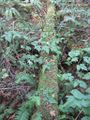
I got out and started walking around to try to find the exact hashpoint. I started down the steep bank with the ferns and the blackberry bushes when I realized that my GPS was kind of wigging out. I guess that I wasn't getting any much closer to the hash (as measured by distance to the point), despite the fact that I was heading in the direction it told me I should be going. My best guess is that my signal wasn't so strong in the fairly narrow, heavily forested valley.
I ended up getting under 10' to the hash, although the point was across the road from where it looked like the hash was on the satellite map. Oh well. I got my requisite pics and headed back to meet the family. Mission accomplished.
Tracklog
The track can be found here.
Photos
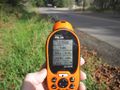
GPS coordinates

Fairly goofy grin
moss covered log somewhat near the hash point, found on my wanderings.


Achievements
- Land Geohash