Difference between revisions of "2010-10-17 53 9"
imported>Mtu |
imported>FippeBot m (Location) |
||
| (11 intermediate revisions by 3 users not shown) | |||
| Line 1: | Line 1: | ||
| − | [[Image:{{{image|2010-10-17_53_9--hash.jpg}}}|thumb|left|Don't | + | {{MtuClustermug |
| + | | lat=53 | ||
| + | | lon=9 | ||
| + | | date=2010-10-17 | ||
| + | | tim = yes | ||
| + | }} | ||
| + | |||
| + | |||
| + | [[Image:{{{image|2010-10-17_53_9--hash.jpg}}}|250px|thumb|left|"Oh shoot... Don't let the hash be in their ducking kitchen!"]] | ||
{{meetup graticule | {{meetup graticule | ||
| Line 9: | Line 17: | ||
__NOTOC__ | __NOTOC__ | ||
== Location == | == Location == | ||
| − | According to Google Earth, on a field just outside a residential area. According to my GPS, right inside someone's house... But | + | According to Google Earth, on a field just outside a residential area. According to my GPS, right inside someone's house... But I'll get to that! |
== Participants == | == Participants == | ||
| Line 16: | Line 24: | ||
==Planning== | ==Planning== | ||
| − | We' | + | This was planned as the second hash in an attempt to get a Consecutive geohash achievement. The conditions were great, the pair of hashes being on a Saturday and Sunday and relatively close to the city. We decided to get rental bikes for this one, but we had a rough start. Let's just say almost half a bottle of ''Ingwerschnaps'' (which is ginger liquor, but try and say ''Ingwerschnaps'', especially if you're a native English speaker—it sounds hilarious!) is one of the less ideal things to be drinking the night before you attempt an early geohash. |
== Expedition == | == Expedition == | ||
| + | [[File:2010-10-17 53 9--mud.jpg|thumb|left|''Very'' funny, OpenStreetMap!]] We set out on the rented bicycles and gleefully followed my GPS's instruction. I had just gotten a kick-ass pocket belt, so I could reach my GPS and my camera while cycling with a minimum of fiddling. I remembered to set the routing algorithm of my GPS from "Car" to "Bicycle", which only a short time later I regretted. | ||
| + | |||
| + | The OpenStreetMap volunteers in Hamburg seem to have a peculiar sense of humor when it comes to the definition of "Footway/Path", and we were lucky to get the bikes through the near-swamp my GPS navigated us through. We were lucky to get the bikes through, because I'm certain the bicycle renting terminals don't have a button labeled "We lost one or more of our bikes in a marsh because we blindly followed our GPS while geohashing." | ||
| + | |||
| + | [[File:2010-10-17 53 9--turn.jpg|thumb|120px|right|''ORLY??'']] After a few more "paths" of the ''maybe-a-dog-runs-by-here-every-month-or-so'' sort, we finally came along a very nice path alongside a creek. The ride was taking longer than expected, and sometimes I got confused by all the "Follow footway/path to footway/path" message on my GPS, but all in all, we got by very well. We also passed by a very nice lake we decided to check out in the summer. | ||
| + | |||
| + | I drew many puzzled looks from the way I studied my GPS while riding, occasionally glancing at the road to compare OSM with RL and circumnavigating all the pesky children permeating the forest, but with the help of good reflexes and many apologies, we managed to get through. | ||
| + | |||
| + | [[File:2010-10-17 53 9--schrebergarten.jpg|thumb|180px|left|The ''Schrebergartensiedlung'']] We were then led by my GPS through something extremely German: A ''Schrebergartensiedlung'', which is a collection of teeny-tiny garden properties with boring little houses, kept in perfect order and neat separation from each other by grumpy old German men with Absolutely Nothing Better To Do. Besides the hedges, which are so meticulously trimmed you might think they used lasers for it, you have little street signs, perfect lawns and dozens of signs forbidding every activity on earth except being a grumpy old German man in a teeny-tiny garden. | ||
| + | |||
| + | Next came a perfect example of physicist behaviour. We were running late and both had plans with other people for the afternoon, and because the ETA on my GPS was ''way'' too optimistic, it dawned on us that time could be a problem. | ||
| + | |||
| + | [[File:2010-10-17 53 9--drehding.jpg|thumb|180px|right|"Look, it spins!!"]] But then we came by '''''one of those rotating thingies for you to sit on a spin yourself!''''' You see, playgrounds are the physicists' version of ''You're a Kitty!'': We can't help but stop and act like we're six years old! So, after a few minutes of confirming the law of the conservation of angular momentum, we got back on the road. It wasn't long now, but... | ||
| + | |||
| + | ...as we were nearing the hash, it dawned on me from my GPS' display | ||
| + | that there must have been quite a discrepancy between where Google Maps | ||
| + | had shown the hash to be and where it actually was according to the navigational satellites. | ||
| + | The residential area we were in was obviously inhabited by elderly, well-to-do Germans, which are | ||
| + | generally, shall we say, not the most sociable and open-minded sort of people. | ||
| + | |||
| + | [[File:2010-10-17 53 9--sign.jpg|thumb|120px|left|They probably had to ask their grandchildren about the English text.]] As we approached the hash itself, I was more and more shocked with every meter: Could it be that the hash was so close and yet so far, and after more than an hour of cycling would be denied to us by the fact that someone had recklessly built a house right on the hash? I was very anxious when I slowly walked up to the house's front door, and I was greatly relieved when I found out that, right in front of the door, we were ''on the hash within the GPS's 3m accuracy radius''. | ||
| + | |||
| + | Now, we still decided to ring the doorbell and ask for permission to stand there and take pictures, lest somebody call | ||
| + | the police. An extremely wary and grouchy elderly woman opened the door (or tried to, because at first it was | ||
| + | locked from the inside—doubly). Now, I realized we had a problem in explaining our request: As far as | ||
| + | anybody in Germany who is over 55 is concerned, the internet is good for nothing | ||
| + | but child pornography, fraudulent crime and terrorists. So while explaining what | ||
| + | we were doing, I carefully avoided the word ''internet'', but still had to say | ||
| + | ''game'', which made the lady even more wary and almost hostile. Only after assuring | ||
| + | her we were only taking pictures of ''ourselves'', she muttered her consent and | ||
| + | immediately slammed the door shut, immediately locking it two or even three times. | ||
| + | |||
| + | We wondered how she was going to explain this incident to her husband later in the day, as she was bound have gotten our story wrong and would probably only be able to recount that two young men with electronic devices has come, asked for permission to be in front of their house, and left again. In order to avert outright panic on their part, we posted the "Internet was here" message on the other side of the street and not on their premises. Still, we are positive that they will have come to the conclusion that Google sent us to photograph their house and post high-definition pictures of it (and of what's ''behind'' the house, and possibly even what's '''''inside!!''''') on the internet out of pure malice, thus, of course, enabling child molesters, fraudsters and terrorists. | ||
| + | |||
| + | [[File:2010-10-17 53 9--apfelsaft.jpg|thumb|120px|right|Look what grows here!]] Curiously, the vegetation we found there, as opposed to the other hashes we've visited, was non-alcoholic. This was very fortunate after the ''Ingwerschnaps'' incident of the preceding night. | ||
| + | |||
| + | When we headed back, we decided to take the metro in order to make it to our appointments. It had been an exciting geohash, featuring quite a bicycle ride and very delicate contact with muggles! | ||
== Tracklog == | == Tracklog == | ||
| − | + | Tracklog in GPX 1.1 format (XML Document) accessible [http://pastebin.ca/1967224 in a pastebin.ca post]. It looks funny to play it back and see how we went really fast when we were on the metro on our way back. | |
== Photos == | == Photos == | ||
<gallery perrow="4"> | <gallery perrow="4"> | ||
| − | + | Image:2010-10-17 53 9--forest.jpg | Many bikers here, as popular a route as it is beautiful! | |
| + | Image:2010-10-17 53 9--see.jpg | Too bad it's almost winter! | ||
| + | Image:2010-10-17 53 9--olbers.jpg | "Look!", I exclaimed: "It's [http://en.wikipedia.org/wiki/Olbers%27_paradox Olbers' paradox], only with, like, tree poles or somethin'!" | ||
| + | Image:2010-10-17 53 9--gps.jpg | We made it! | ||
| + | Image:2010-10-17 53 9--stupidgrin.jpg | There's always time for a Stupid Grin! | ||
| + | Image:2010-10-17 53 9--bahn.jpg | Waiting for the metro on the way back. | ||
</gallery> | </gallery> | ||
== Achievements == | == Achievements == | ||
{{#vardefine:ribbonwidth|800px}} | {{#vardefine:ribbonwidth|800px}} | ||
| − | {{land geohash | + | {{Radio Yerevan|achievement = [[land geohash|land geohash achievement]]|detail=mtu's GPS had a wrong map datum set, missing the hash by about 200 m|latitude=53|longitude=9|date=2010-10-17|user = [[User:Mtu|mtu]] and [[User:Seamus_d|seamus_d]] |
| − | + | |image = 2010-10-17_53_9--hash.jpg}} | |
| − | + | {{Radio Yerevan|achievement = [[Bicycle geohash|Bicycle geohash achievement]]|detail=mtu's GPS had a wrong map datum set, missing the hash by about 200 m|latitude=53|longitude=9|date=2010-10-17|user = [[User:Mtu|mtu]] and [[User:Seamus_d|seamus_d]] | |
| − | + | |image = 2010-10-17 53 9--mud.jpg}} | |
| − | + | {{Radio Yerevan|achievement = [[consecutive geohash|consecutive geohash achievement]] by reaching 2 consecutive hash points starting on [[2010-10-16]]|detail=mtu's GPS had a wrong map datum set, missing both hashes by about 200 m|latitude=53|longitude=9|date=2010-10-17|user = [[User:Mtu|mtu]] and [[User:Seamus_d|seamus_d]]}} | |
| − | |||
| − | }} | ||
| − | {{Bicycle geohash | ||
| − | |||
| − | |||
| − | |||
| − | |||
| − | |||
| − | }} | ||
| − | {{consecutive geohash | ||
| − | |||
| − | |||
| − | |||
| − | |||
| − | |||
| − | }} | ||
[[Category:Expeditions]] | [[Category:Expeditions]] | ||
[[Category:Expeditions with photos]] | [[Category:Expeditions with photos]] | ||
| − | + | {{location|DE|SH|PI}} | |
Latest revision as of 04:16, 9 August 2019
For his first five geohashes, mtu had the wrong map datum set on his GPS device—namely the Potsdam datum instead of the globally accepted standard, WGS 84—causing him to not visit the actual, canonical hashpoints, but places about 200 m away in SSW-erly direction.
In all cases, the actual hashpoints would have been easily accessible, but were missed by 20–200 m solely due to mtu's ineptitude.
In commemoration of this epic fail,
mtu earned the False Start Consolation Prize
|
Accompanying mtu on several expeditions, seamus_d suffered from the same problem, so
seamus_d earned the False Start Consolation Prize
|
As a consequence, all achievements formerly claimed for this hash are null and void (except Drag-along achievements). Instead,
mtu and seamus_d earned the Blinded by Science Consolation Prize
|
Please note that the expedition narrative was written before this became known!
| Sun 17 Oct 2010 in 53,9: 53.6340020, 9.8707579 geohashing.info google osm bing/os kml crox |
Location
According to Google Earth, on a field just outside a residential area. According to my GPS, right inside someone's house... But I'll get to that!
Participants
Planning
This was planned as the second hash in an attempt to get a Consecutive geohash achievement. The conditions were great, the pair of hashes being on a Saturday and Sunday and relatively close to the city. We decided to get rental bikes for this one, but we had a rough start. Let's just say almost half a bottle of Ingwerschnaps (which is ginger liquor, but try and say Ingwerschnaps, especially if you're a native English speaker—it sounds hilarious!) is one of the less ideal things to be drinking the night before you attempt an early geohash.
Expedition
We set out on the rented bicycles and gleefully followed my GPS's instruction. I had just gotten a kick-ass pocket belt, so I could reach my GPS and my camera while cycling with a minimum of fiddling. I remembered to set the routing algorithm of my GPS from "Car" to "Bicycle", which only a short time later I regretted.
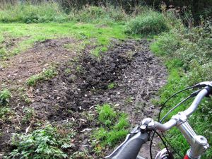
The OpenStreetMap volunteers in Hamburg seem to have a peculiar sense of humor when it comes to the definition of "Footway/Path", and we were lucky to get the bikes through the near-swamp my GPS navigated us through. We were lucky to get the bikes through, because I'm certain the bicycle renting terminals don't have a button labeled "We lost one or more of our bikes in a marsh because we blindly followed our GPS while geohashing."
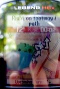
After a few more "paths" of the maybe-a-dog-runs-by-here-every-month-or-so sort, we finally came along a very nice path alongside a creek. The ride was taking longer than expected, and sometimes I got confused by all the "Follow footway/path to footway/path" message on my GPS, but all in all, we got by very well. We also passed by a very nice lake we decided to check out in the summer.
I drew many puzzled looks from the way I studied my GPS while riding, occasionally glancing at the road to compare OSM with RL and circumnavigating all the pesky children permeating the forest, but with the help of good reflexes and many apologies, we managed to get through.
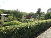
We were then led by my GPS through something extremely German: A Schrebergartensiedlung, which is a collection of teeny-tiny garden properties with boring little houses, kept in perfect order and neat separation from each other by grumpy old German men with Absolutely Nothing Better To Do. Besides the hedges, which are so meticulously trimmed you might think they used lasers for it, you have little street signs, perfect lawns and dozens of signs forbidding every activity on earth except being a grumpy old German man in a teeny-tiny garden.
Next came a perfect example of physicist behaviour. We were running late and both had plans with other people for the afternoon, and because the ETA on my GPS was way too optimistic, it dawned on us that time could be a problem.
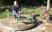
But then we came by one of those rotating thingies for you to sit on a spin yourself! You see, playgrounds are the physicists' version of You're a Kitty!: We can't help but stop and act like we're six years old! So, after a few minutes of confirming the law of the conservation of angular momentum, we got back on the road. It wasn't long now, but...
...as we were nearing the hash, it dawned on me from my GPS' display that there must have been quite a discrepancy between where Google Maps had shown the hash to be and where it actually was according to the navigational satellites. The residential area we were in was obviously inhabited by elderly, well-to-do Germans, which are generally, shall we say, not the most sociable and open-minded sort of people.
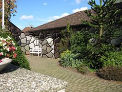
As we approached the hash itself, I was more and more shocked with every meter: Could it be that the hash was so close and yet so far, and after more than an hour of cycling would be denied to us by the fact that someone had recklessly built a house right on the hash? I was very anxious when I slowly walked up to the house's front door, and I was greatly relieved when I found out that, right in front of the door, we were on the hash within the GPS's 3m accuracy radius.
Now, we still decided to ring the doorbell and ask for permission to stand there and take pictures, lest somebody call the police. An extremely wary and grouchy elderly woman opened the door (or tried to, because at first it was locked from the inside—doubly). Now, I realized we had a problem in explaining our request: As far as anybody in Germany who is over 55 is concerned, the internet is good for nothing but child pornography, fraudulent crime and terrorists. So while explaining what we were doing, I carefully avoided the word internet, but still had to say game, which made the lady even more wary and almost hostile. Only after assuring her we were only taking pictures of ourselves, she muttered her consent and immediately slammed the door shut, immediately locking it two or even three times.
We wondered how she was going to explain this incident to her husband later in the day, as she was bound have gotten our story wrong and would probably only be able to recount that two young men with electronic devices has come, asked for permission to be in front of their house, and left again. In order to avert outright panic on their part, we posted the "Internet was here" message on the other side of the street and not on their premises. Still, we are positive that they will have come to the conclusion that Google sent us to photograph their house and post high-definition pictures of it (and of what's behind the house, and possibly even what's inside!!) on the internet out of pure malice, thus, of course, enabling child molesters, fraudsters and terrorists.
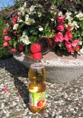
Curiously, the vegetation we found there, as opposed to the other hashes we've visited, was non-alcoholic. This was very fortunate after the Ingwerschnaps incident of the preceding night.
When we headed back, we decided to take the metro in order to make it to our appointments. It had been an exciting geohash, featuring quite a bicycle ride and very delicate contact with muggles!
Tracklog
Tracklog in GPX 1.1 format (XML Document) accessible in a pastebin.ca post. It looks funny to play it back and see how we went really fast when we were on the metro on our way back.
Photos
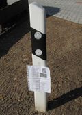
"Look!", I exclaimed: "It's Olbers' paradox, only with, like, tree poles or somethin'!"
Achievements
Is it true that mtu and seamus_d earned the land geohash achievement?
|
Is it true that mtu and seamus_d earned the Bicycle geohash achievement?
|
Is it true that mtu and seamus_d earned the consecutive geohash achievement by reaching 2 consecutive hash points starting on 2010-10-16?
|
