Difference between revisions of "2010-10-24 55 14"
imported>Llavids (Created page with '{{meetup graticule | lat=54 | lon=14 | date=2010-10-24 }} __NOTOC__ == Location == In the forest west of Huaröd, Skåne, Sweden. == …') |
imported>FippeBot m (Location) |
||
| (5 intermediate revisions by 2 users not shown) | |||
| Line 1: | Line 1: | ||
{{meetup graticule | {{meetup graticule | ||
| − | | lat= | + | | lat=55 |
| lon=14 | | lon=14 | ||
| date=2010-10-24 | | date=2010-10-24 | ||
| Line 7: | Line 7: | ||
__NOTOC__ | __NOTOC__ | ||
== Location == | == Location == | ||
| − | In the forest | + | In the forest east of Huaröd, [[wikipedia:Skåne|Skåne]], [[wikipedia:Sweden|Sweden]]. |
== Participants == | == Participants == | ||
| Line 13: | Line 13: | ||
== Plans == | == Plans == | ||
| − | . | + | When I saw the Sunday geohash location I remembered driving by there in July, when I visited the largest flea market in the summer in Degeberga. |
| + | |||
| + | I actually stopped the car to take a leak before returning home. So I was curious about how close it was from my earlier visit. The place would also get me | ||
| + | a minesweeper graticule. It wasn't going to be closer to home than this. I had to go, the only thing to stop me was if anybody was hunting in the area. | ||
== Expedition == | == Expedition == | ||
| − | . | + | I followed the same road as earlier in the summer. It was the same route. When passing the earlier car stop I checked the GPS and I had parked my car only 670 meters from the geohash location. I must have been closer when I was walking in the forest that day in the summer. |
| + | |||
| + | When arriving closer I found a road into the forest, but it was barred. I could see that it had been used yesterday or the same morning. But it was only a 220 meter walk. When getting closer I had to get inside a dense forest of pine trees, then down a slope where there was a creek. | ||
| + | |||
| + | It was hard for the GPS to find any good readings so I walked up and down the creek, and also over the creek twice and up again. Eventually I got 2 meters off, but it soon started to change again. The most probable location had a small island in the creek and I put the camera on a tree root to get a steady picture. It was really hard to get enough light for the camera, and I had forgotten my small tripod so most pictures are a bit blurred. It was also raining which didn't help. I got some pictures and when returning I found the elk droppings, fairly freshly laid. I also took a picture of one of the hunting towers I saw before returning to the car to drive back home. | ||
== Photos == | == Photos == | ||
| Line 34: | Line 41: | ||
== Achievements == | == Achievements == | ||
{{#vardefine:ribbonwidth|800px}} | {{#vardefine:ribbonwidth|800px}} | ||
| + | |||
| + | {{Land geohash | latitude = 55 | longitude = 14 | date = 2010-10-24 | name = [[User:Llavids|Llavids]] }} | ||
| + | |||
{{Minesweeper geohash | {{Minesweeper geohash | ||
| graticule = Malmö, Sweden | | graticule = Malmö, Sweden | ||
| Line 47: | Line 57: | ||
[[Category:Expeditions with photos]] | [[Category:Expeditions with photos]] | ||
[[Category:Coordinates reached]] | [[Category:Coordinates reached]] | ||
| − | + | ||
[[Category:Sweden]] | [[Category:Sweden]] | ||
| + | {{location|SE|M}} | ||
Latest revision as of 04:20, 9 August 2019
| Sun 24 Oct 2010 in 55,14: 55.8226304, 14.0183318 geohashing.info google osm bing/os kml crox |
Location
In the forest east of Huaröd, Skåne, Sweden.
Participants
Plans
When I saw the Sunday geohash location I remembered driving by there in July, when I visited the largest flea market in the summer in Degeberga.
I actually stopped the car to take a leak before returning home. So I was curious about how close it was from my earlier visit. The place would also get me a minesweeper graticule. It wasn't going to be closer to home than this. I had to go, the only thing to stop me was if anybody was hunting in the area.
Expedition
I followed the same road as earlier in the summer. It was the same route. When passing the earlier car stop I checked the GPS and I had parked my car only 670 meters from the geohash location. I must have been closer when I was walking in the forest that day in the summer.
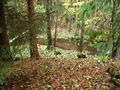
When arriving closer I found a road into the forest, but it was barred. I could see that it had been used yesterday or the same morning. But it was only a 220 meter walk. When getting closer I had to get inside a dense forest of pine trees, then down a slope where there was a creek.
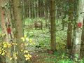
It was hard for the GPS to find any good readings so I walked up and down the creek, and also over the creek twice and up again. Eventually I got 2 meters off, but it soon started to change again. The most probable location had a small island in the creek and I put the camera on a tree root to get a steady picture. It was really hard to get enough light for the camera, and I had forgotten my small tripod so most pictures are a bit blurred. It was also raining which didn't help. I got some pictures and when returning I found the elk droppings, fairly freshly laid. I also took a picture of one of the hunting towers I saw before returning to the car to drive back home.
Photos
Go in here to the last meters
Get down here
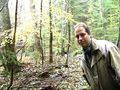
I'm here
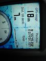
Proof
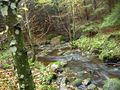
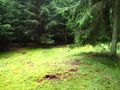
Surroundings
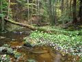
Surroundings
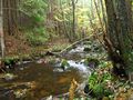
Surroundings
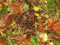
Elk droppings nearby
No hunting today (luckily)


Achievements
Llavids earned the Land geohash achievement
|
Llavids achieved level 3 of the Minesweeper Geohash achievement
|