Difference between revisions of "2010-11-11 43 -116"
imported>Jrmhkts (Created page with '{{subst:Expedition |lat = 43 |lon = -116 |date = 2010-11-11 }}') |
m (per Renaming Proposal) |
||
| (9 intermediate revisions by 4 users not shown) | |||
| Line 1: | Line 1: | ||
| − | + | __NOTOC__ | |
| − | |||
| − | |||
| − | |||
| − | |||
| − | |||
| − | |||
| − | |||
| − | |||
| − | |||
{{meetup graticule | {{meetup graticule | ||
| lat=43 | | lat=43 | ||
| Line 14: | Line 5: | ||
| date=2010-11-11 | | date=2010-11-11 | ||
}} | }} | ||
| − | |||
| − | |||
| − | |||
== Location == | == Location == | ||
| − | + | Located on a cul-de-sac in Meridian near W. Pine Ave. between Ten Mile and Linder. | |
== Participants == | == Participants == | ||
| − | + | * [[User:Jrmhkts|Jrmhkts]] | |
| + | * Laura | ||
== Plans == | == Plans == | ||
| − | + | I received an email from [[user:dvdllr|David]] earlier today alerting me that the geohash was a mere 1.25 miles away from my home. I have been meaning to go on a geohash for quite a while now, but had not had a chance to before today. I decided I would go after work, although I was a bit unprepared. I didn't have a camera with charged batteries or even a printer with which to print off directions, so I was going to have to rely on my phone to do all the navigating and photography. | |
== Expedition == | == Expedition == | ||
| − | + | I mentioned the idea to my wife, who was interested in the idea, so after the two of us arrived home from work we headed to the geohash location, which was an easy drive from our house. Really nothing of note happened while we were there except that a cat jumped on the hood of her car. Despite this fact, it was a lot of fun and we plan to do more in the future. We took a few pictures, although most of them didn't turn out well because I only had the camera on my phone. I plan to update this page more tomorrow (including adding pictures). | |
| + | <!-- Remove if not needed | ||
== Tracklog == | == Tracklog == | ||
| − | + | if your GPS device keeps a log, you may post a link here | |
| + | --> | ||
== Photos == | == Photos == | ||
| − | |||
| − | |||
| − | |||
<gallery perrow="5"> | <gallery perrow="5"> | ||
| + | Image:2010-11-11 43 -116 1.jpg | Hashpoint | ||
| + | Image:2010-11-11 43 -116 2.PNG | Proof | ||
| + | Image:2010-11-11 43 -116 3.jpg | Geohashers | ||
</gallery> | </gallery> | ||
== Achievements == | == Achievements == | ||
{{#vardefine:ribbonwidth|800px}} | {{#vardefine:ribbonwidth|800px}} | ||
| − | + | {{land geohash | |
| + | | latitude = 43 | ||
| + | | longitude = -116 | ||
| + | | date = 2010-11-11 | ||
| + | | name = [[User:Jrmhkts|Jrmhkts]] & Laura | ||
| + | }} | ||
| + | {{Graticule unlocked | ||
| − | + | | latitude = 43 | |
| − | + | | longitude = -116 | |
| − | [[ | + | | date = 2010-11-11 |
| + | | name = [[User:Jrmhkts|Jrmhkts]] & Laura | ||
| + | }} | ||
| − | |||
| − | |||
| − | |||
| − | |||
| − | |||
| − | |||
[[Category:Expeditions]] | [[Category:Expeditions]] | ||
| − | |||
[[Category:Expeditions with photos]] | [[Category:Expeditions with photos]] | ||
| + | [[Category:Coordinates reached]] | ||
| + | |||
| + | <!-- Remove if not needed | ||
[[Category:Expeditions with videos]] | [[Category:Expeditions with videos]] | ||
[[Category:Expedition without GPS]] | [[Category:Expedition without GPS]] | ||
--> | --> | ||
| − | + | {{location|US|ID|AA}} | |
| − | |||
| − | |||
| − | |||
| − | |||
| − | |||
| − | |||
| − | |||
| − | |||
| − | |||
| − | |||
| − | |||
| − | |||
Latest revision as of 05:59, 20 March 2024
| Thu 11 Nov 2010 in 43,-116: 43.6099679, -116.4228802 geohashing.info google osm bing/os kml crox |
Location
Located on a cul-de-sac in Meridian near W. Pine Ave. between Ten Mile and Linder.
Participants
- Jrmhkts
- Laura
Plans
I received an email from David earlier today alerting me that the geohash was a mere 1.25 miles away from my home. I have been meaning to go on a geohash for quite a while now, but had not had a chance to before today. I decided I would go after work, although I was a bit unprepared. I didn't have a camera with charged batteries or even a printer with which to print off directions, so I was going to have to rely on my phone to do all the navigating and photography.
Expedition
I mentioned the idea to my wife, who was interested in the idea, so after the two of us arrived home from work we headed to the geohash location, which was an easy drive from our house. Really nothing of note happened while we were there except that a cat jumped on the hood of her car. Despite this fact, it was a lot of fun and we plan to do more in the future. We took a few pictures, although most of them didn't turn out well because I only had the camera on my phone. I plan to update this page more tomorrow (including adding pictures).
Photos
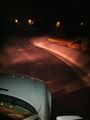
Hashpoint
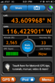
Proof

Geohashers


Achievements
Jrmhkts & Laura earned the Land geohash achievement
|
Jrmhkts & Laura earned the Graticule Unlocked Achievement
|