Difference between revisions of "2010-12-10 59 17"
imported>Vswe (Created page with '{{meetup graticule | lat=59 | lon=17 | date=2010-12-10 }} __NOTOC__ == Location == On a field outside Uppsala. == Participants == *Vswe == Plans == == Expedition…') |
imported>FippeBot m (Location) |
||
| (5 intermediate revisions by one other user not shown) | |||
| Line 13: | Line 13: | ||
== Plans == | == Plans == | ||
== Expedition == | == Expedition == | ||
| − | + | After school I headed down to the train station and took bus number 809. Luckily I had added the coordinate of the bus stop into the GPS(lesson learned from other expeditions) cause on the bus nothing actually told me when my bus stop were coming. But when the GPS said it was 500 meters to go I just hit the stop button :). Anyway, after the bus I followed the small road until I were about 100 meters from the hashpoint, then I had to go onto the snowy field. First went a bit wrong but then with out any major problems I found the point. Took some pictures and headed back home. | |
| + | |||
| + | == Tracklog == | ||
| + | Tracklog[http://maps.google.com/maps/ms?hl=en&ie=UTF8&t=h&msa=0&msid=110921429028229839370.0004972505b3ca4a3df23&ll=59.860506,17.722664&spn=0.098431,0.197411&z=12] | ||
| + | |||
| + | == Photos == | ||
| + | Note: All images are kinda blurry, the reason is that is was very cold and I can't operate the camera with gloves on. You can guess the rest. | ||
| + | <gallery perrow="5"> | ||
| + | Image:2010-12-10_59_17_view1.jpg | Onto the small road. | ||
| + | Image:2010-12-10_59_17_view2.jpg | 15:17. It was still light. | ||
| + | Image:2010-12-10_59_17_view3.jpg | 15:27. Very dark, just 10 minutes later. | ||
| + | Image:2010-12-10_59_17_view4.jpg | The hashpoint is on that field. | ||
| + | Image:2010-12-10_59_17_GPS.jpg | 1 meter to go(Proof). | ||
| + | Image:2010-12-10_59_17_me.jpg | [[:Category:Grins|Stupid Grin]]<sup>tm</sup> | ||
| + | </gallery> | ||
| + | |||
| + | == Achievements == | ||
| + | {{#vardefine:ribbonwidth|800px}} | ||
| + | {{Public transport geohash | latitude = 59 | longitude = 17 | date = 2010-12-10 | busline = bus 809| name = Vswe}} | ||
| + | {{land geohash | latitude = 59 | longitude = 17 | date = 2010-12-10 | name = Vswe }} | ||
[[Category:Expeditions]] | [[Category:Expeditions]] | ||
| − | + | [[Category:Expeditions with photos]] | |
[[Category:Coordinates reached]] | [[Category:Coordinates reached]] | ||
| + | {{location|SE|C}} | ||
Latest revision as of 04:53, 9 August 2019
| Fri 10 Dec 2010 in 59,17: 59.8660290, 17.7969332 geohashing.info google osm bing/os kml crox |
Location
On a field outside Uppsala.
Participants
Plans
Expedition
After school I headed down to the train station and took bus number 809. Luckily I had added the coordinate of the bus stop into the GPS(lesson learned from other expeditions) cause on the bus nothing actually told me when my bus stop were coming. But when the GPS said it was 500 meters to go I just hit the stop button :). Anyway, after the bus I followed the small road until I were about 100 meters from the hashpoint, then I had to go onto the snowy field. First went a bit wrong but then with out any major problems I found the point. Took some pictures and headed back home.
Tracklog
Tracklog[1]
Photos
Note: All images are kinda blurry, the reason is that is was very cold and I can't operate the camera with gloves on. You can guess the rest.
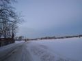
Onto the small road.
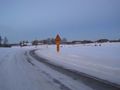
15:17. It was still light.
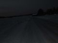
15:27. Very dark, just 10 minutes later.
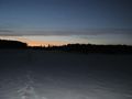
The hashpoint is on that field.
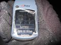
1 meter to go(Proof).


Achievements
Vswe earned the Public transport geohash achievement
|
Vswe earned the Land geohash achievement
|