Difference between revisions of "2011-01-02 60 22"
imported>Suurnesu |
imported>FippeBot m (Location) |
||
| (2 intermediate revisions by one other user not shown) | |||
| Line 13: | Line 13: | ||
== Expedition == | == Expedition == | ||
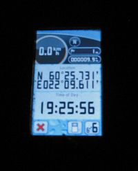
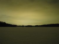
| + | Hashpoint seemed to be on so nice location that I just had to do a little evening cycling there. It was very nice to cycle through the calm and dark Ruissalo, not even street lights on the last few kilometers so I had to also shut down my bike lights so the atmosphere was perfect. At the hash point there was clear marks of Meset's visit, so I used the same footsteps to walk to 0-point. Took few pictures from the beautiful view and continued to the nearby geocache to drop some travellers. Visited the hash location at 19:25. | ||
| + | |||
| + | - nsk | ||
| + | |||
The hashpoint landed on the Island of Ruissalo, only a few kilometers from the Turku city centre. Looking at the map it was clear that the point was only about 10 meters from the road. This road is very familiar to me, because it leads to the Yacht Club of Turku, where my sailing boat is kept. | The hashpoint landed on the Island of Ruissalo, only a few kilometers from the Turku city centre. Looking at the map it was clear that the point was only about 10 meters from the road. This road is very familiar to me, because it leads to the Yacht Club of Turku, where my sailing boat is kept. | ||
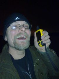
When I came to close to the hash point, I couldn't possibly miss seeing the previous foot marks in the approximately 40 cm deep snow. I took a traditional silly-grim-photo, and drove back home. | When I came to close to the hash point, I couldn't possibly miss seeing the previous foot marks in the approximately 40 cm deep snow. I took a traditional silly-grim-photo, and drove back home. | ||
| Line 21: | Line 25: | ||
[[File:60_22_02012011a.jpg|200px|thumb|left|Clear marks at the spot]] | [[File:60_22_02012011a.jpg|200px|thumb|left|Clear marks at the spot]] | ||
[[File:60_22_02012011b.jpg|200px|thumb|left|Suurnesu at the spot]] | [[File:60_22_02012011b.jpg|200px|thumb|left|Suurnesu at the spot]] | ||
| − | + | [[File:2011-01-02_60_22_gpsr.jpg|200px|thumb|left|nsk's GPS at the 0-point]] | |
| + | [[File:2011-01-02_60_22_view.jpg|200px|thumb|left|View from the hashpoint]] | ||
[[Category:Expeditions]] | [[Category:Expeditions]] | ||
[[Category:Expeditions with photos]] | [[Category:Expeditions with photos]] | ||
[[Category:Coordinates reached]] | [[Category:Coordinates reached]] | ||
| + | {{location|FI|19}} | ||
Latest revision as of 05:08, 9 August 2019
| Sun 2 Jan 2011 in Turku: 60.4288468, 22.1601836 geohashing.info google osm bing/os kml crox |
Participants
Expedition
Hashpoint seemed to be on so nice location that I just had to do a little evening cycling there. It was very nice to cycle through the calm and dark Ruissalo, not even street lights on the last few kilometers so I had to also shut down my bike lights so the atmosphere was perfect. At the hash point there was clear marks of Meset's visit, so I used the same footsteps to walk to 0-point. Took few pictures from the beautiful view and continued to the nearby geocache to drop some travellers. Visited the hash location at 19:25.
- nsk
The hashpoint landed on the Island of Ruissalo, only a few kilometers from the Turku city centre. Looking at the map it was clear that the point was only about 10 meters from the road. This road is very familiar to me, because it leads to the Yacht Club of Turku, where my sailing boat is kept. When I came to close to the hash point, I couldn't possibly miss seeing the previous foot marks in the approximately 40 cm deep snow. I took a traditional silly-grim-photo, and drove back home.
- Suurnesu


