Difference between revisions of "2011-01-22 50 8"
imported>Mampfred |
imported>FippeBot m (Location) |
||
| (2 intermediate revisions by 2 users not shown) | |||
| Line 14: | Line 14: | ||
== Plans == | == Plans == | ||
| − | We're in the | + | We're in the general area anyway for some weekend familiy visits, so we'll try and make a little detour to get this hash. Should be easily reachable via existing tracks in the woods. |
== Expedition == | == Expedition == | ||
| − | As expected, we found the entry in the woods we were looking for straight away. Picked the wrong path first so when that came to an end (at a little water station, see pictures) we had to climb up through the woods to get to the next "higher" path as the whole wood was on a little hill. From there it was a piece of cake, about 25 meters from the path. Left the active geohashing marker, took | + | As expected, we found the entry in the woods we were looking for straight away. Picked the wrong path first so when that came to an end (at a little water station, see pictures) we had to climb up through the woods to get to the next "higher" path as the whole wood was on a little hill. From there it was a piece of cake, about 25 meters from the path. Left the active geohashing marker, took some photos and headed back. |
We think it was _just_ cold enough for a frozen hash but then again there's no proof and there's probably plenty more frozen hashes ... next year. | We think it was _just_ cold enough for a frozen hash but then again there's no proof and there's probably plenty more frozen hashes ... next year. | ||
| Line 25: | Line 25: | ||
== Photos == | == Photos == | ||
| − | |||
| − | |||
| − | |||
| − | |||
<gallery perrow="5"> | <gallery perrow="5"> | ||
| + | Image:2011-01-22_50_8_car.jpg | Hash car | ||
| + | Image:2011-01-22_50_8_sign.jpg | Motor vehicles prohibited, goot thing we planned on walking there ;) | ||
| + | Image:2011-01-22_50_8_water_station.jpg | Water station Guntersdorf + LadyBB | ||
| + | Image:2011-01-22_50_8_wasserwerk_guntersdorf.jpg | Closeup of the water station | ||
| + | Image:2011-01-22_50_8_coordinates.jpg | Coordinates ... | ||
| + | Image:2011-01-22_50_8_reached.jpg | ... reached | ||
| + | Image:2011-01-22_50_8_hash_marker.jpg | Hash marker | ||
| + | Image:2011-01-22_50_8_grin.jpg | Stupid grin in front of hashmarker | ||
| + | Image:2011-01-22_50_8_hash.jpg | The hash site | ||
| + | Image:2011-01-22_50_8_hashmarker_small.jpg | Can you spot the hash marker? | ||
| + | Image:2011-01-22_50_8_tunnel.jpg | There's a light at the end of the tunnel | ||
| + | Image:2011-01-22_50_8_water_1.jpg | Nature ... | ||
| + | Image:2011-01-22_50_8_water_2.jpg | ... and more nature. | ||
</gallery> | </gallery> | ||
| Line 44: | Line 53: | ||
[[Category:Expeditions with photos]] | [[Category:Expeditions with photos]] | ||
[[Category:Coordinates reached]] | [[Category:Coordinates reached]] | ||
| + | {{location|DE|HE|LDK}} | ||
Latest revision as of 05:19, 9 August 2019
| Sat 22 Jan 2011 in 50,8: 50.6452530, 8.2534982 geohashing.info google osm bing/os kml crox |
Location
In the woods near Herborn between Hirschberg and Guntersdorf.
Participants
Plans
We're in the general area anyway for some weekend familiy visits, so we'll try and make a little detour to get this hash. Should be easily reachable via existing tracks in the woods.
Expedition
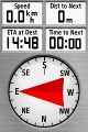
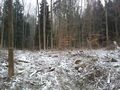
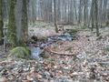
As expected, we found the entry in the woods we were looking for straight away. Picked the wrong path first so when that came to an end (at a little water station, see pictures) we had to climb up through the woods to get to the next "higher" path as the whole wood was on a little hill. From there it was a piece of cake, about 25 meters from the path. Left the active geohashing marker, took some photos and headed back.
We think it was _just_ cold enough for a frozen hash but then again there's no proof and there's probably plenty more frozen hashes ... next year.
Tracklog
See here.
Photos
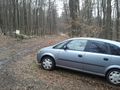
Hash car
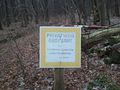
Motor vehicles prohibited, goot thing we planned on walking there ;)
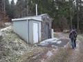
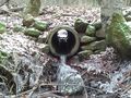
Water station Guntersdorf + LadyBB
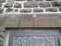
Closeup of the water station
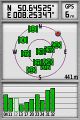
Coordinates ...
... reached
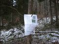
Hash marker
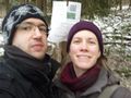
Stupid grin in front of hashmarker
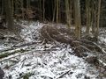
The hash site
Can you spot the hash marker?
There's a light at the end of the tunnel
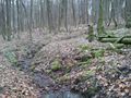
Nature ...
... and more nature.


Achievements
Mampfred and LadyBB earned the Land geohash achievement
|