Difference between revisions of "2011-01-26 50 9"
From Geohashing
imported>Mampfred (Created page with "{{subst:Expedition |lat = 50 |lon = 9 |date = 2011-01-26 }}") |
imported>FippeBot m (Location) |
||
| (4 intermediate revisions by one other user not shown) | |||
| Line 1: | Line 1: | ||
| − | |||
| − | |||
| − | |||
| − | |||
| − | |||
| − | |||
| − | |||
| − | |||
| − | |||
| − | |||
{{meetup graticule | {{meetup graticule | ||
| lat=50 | | lat=50 | ||
| Line 15: | Line 5: | ||
}} | }} | ||
| − | |||
__NOTOC__ | __NOTOC__ | ||
== Location == | == Location == | ||
| − | + | South of Fulda next to a little village called Mittelkalbach. Strip of grass according to google maps. | |
== Participants == | == Participants == | ||
| − | + | * [[User:Mampfred|Mampfred]] | |
| + | * [[User:Rincewind|Rincewind]] | ||
== Plans == | == Plans == | ||
| − | + | We'll make a detour on our way home from working in Erfurt. If we're lucky we'll finally get the first successful hash in [[50,9]] :) | |
== Expedition == | == Expedition == | ||
| − | + | Very uneventful, wedrove as close as possible and hiked the last 300 meters across frozen grassland and the rest of the snow that seems to be stuck in this area. Speaking of which, finally a frozen hash which we didn't quite expect as the rest of germany seems to be a lot warmer that this strange place in the middle of nowhere ;) | |
== Tracklog == | == Tracklog == | ||
| − | + | See [http://www.everytrail.com/view_trip.php?trip_id=947318 here]. | |
== Photos == | == Photos == | ||
| − | |||
| − | |||
| − | |||
<gallery perrow="5"> | <gallery perrow="5"> | ||
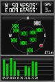
| + | Image:2011-01-26 50 9 coordinates.jpg | Coordinates ... | ||
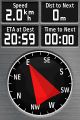
| + | Image:2011-01-26 50 9 reached.jpg | ... reached. | ||
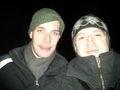
| + | Image:2011-01-26_50_9_grin.jpg | Stupid grin. | ||
| + | Image:2011-01-26_50_9_frozen.jpg | Frozen: it says -4°C. | ||
| + | Image:2011-01-26_50_9_kalbach_at_night.jpg | Kalbach @ night. | ||
</gallery> | </gallery> | ||
== Achievements == | == Achievements == | ||
{{#vardefine:ribbonwidth|800px}} | {{#vardefine:ribbonwidth|800px}} | ||
| − | + | {{Minesweeper geohash | |
| + | | graticule = Schweinfurt, Germany | ||
| + | | ranknumber = 4 | ||
| + | | w = true | ||
| + | | n = true | ||
| + | | e = true | ||
| + | | ne = true | ||
| + | | name = Mampfred and Rincewind | ||
| + | }} | ||
| + | {{Land geohash | ||
| + | | latitude = 50 | ||
| + | | longitude = 9 | ||
| + | | date = 2011-01-26 | ||
| + | | name = [[User:Mampfred|Mampfred]] and [[User:Rincewind|Rincewind]] | ||
| + | }} | ||
| + | {{Frozen Geohash | ||
| + | | latitude = 50 | ||
| + | | longitude = 9 | ||
| + | | date = 2011-01-26 | ||
| + | | name = [[User:Mampfred|Mampfred]] and [[User:Rincewind|Rincewind]] | ||
| + | }} | ||
| − | |||
| − | |||
| − | |||
| − | |||
| − | |||
| − | |||
| − | |||
| − | |||
| − | |||
| − | |||
| − | |||
[[Category:Expeditions]] | [[Category:Expeditions]] | ||
| − | |||
[[Category:Expeditions with photos]] | [[Category:Expeditions with photos]] | ||
| − | |||
| − | |||
| − | |||
| − | |||
| − | |||
[[Category:Coordinates reached]] | [[Category:Coordinates reached]] | ||
| − | + | {{location|DE|HE|FD}} | |
| − | |||
| − | |||
| − | |||
| − | |||
| − | |||
| − | |||
| − | |||
| − | |||
| − | |||
Latest revision as of 05:21, 9 August 2019
| Wed 26 Jan 2011 in 50,9: 50.4250478, 9.6546455 geohashing.info google osm bing/os kml crox |
Location
South of Fulda next to a little village called Mittelkalbach. Strip of grass according to google maps.
Participants
Plans
We'll make a detour on our way home from working in Erfurt. If we're lucky we'll finally get the first successful hash in 50,9 :)
Expedition
Very uneventful, wedrove as close as possible and hiked the last 300 meters across frozen grassland and the rest of the snow that seems to be stuck in this area. Speaking of which, finally a frozen hash which we didn't quite expect as the rest of germany seems to be a lot warmer that this strange place in the middle of nowhere ;)
Tracklog
See here.
Photos
Coordinates ...
... reached.
Stupid grin.
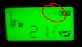
Frozen: it says -4°C.
Kalbach @ night.


Achievements
Mampfred and Rincewind achieved level 4 of the Minesweeper Geohash achievement
|
Mampfred and Rincewind earned the Land geohash achievement
|
Mampfred and Rincewind earned the Frozen Geohash Achievement
|