Difference between revisions of "2011-02-01 45 -122"
From Geohashing
imported>Mampfred |
imported>FippeBot m (Location) |
||
| (One intermediate revision by one other user not shown) | |||
| Line 23: | Line 23: | ||
== Photos == | == Photos == | ||
| − | + | ||
<gallery perrow="5"> | <gallery perrow="5"> | ||
| + | |||
| + | Image:2011-02-01_45_-122-GPS.jpg | The GPS near the hashpoint | ||
| + | Image:2011-02-01_45_-122-corner.jpg | The nearby corner | ||
| + | |||
</gallery> | </gallery> | ||
== Achievements == | == Achievements == | ||
{{#vardefine:ribbonwidth|800px}} | {{#vardefine:ribbonwidth|800px}} | ||
| − | |||
* No Trespassing | * No Trespassing | ||
| Line 37: | Line 40: | ||
[[Category:Coordinates not reached]] | [[Category:Coordinates not reached]] | ||
[[Category:Not reached - No public access]] | [[Category:Not reached - No public access]] | ||
| + | {{location|US|OR|MU}} | ||
Latest revision as of 05:25, 9 August 2019
| Tue 1 Feb 2011 in 45,-122: 45.5601029, -122.7850583 geohashing.info google osm bing/os kml crox |
Location
Skyline Blvd, Near Portland
Participants
Plans
Since it was pretty near by, Jim figured he'd make a try for it after work.
Expedition
The trip was fairly straightforward, despite the rather curvy roads. I finally got to the hash point, and it was clearly on private property. If it hadn't been dark, I might have tried for permission, but I wasn't up for it.
I turned around and headed home for dinner.
Photos
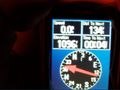
The GPS near the hashpoint
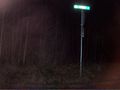
The nearby corner


Achievements
- No Trespassing