Difference between revisions of "2011-03-01 50 8"
imported>Mampfred (Created page with "{{subst:Expedition |lat = 50 |lon = 8 |date = 2011-03-01 }}") |
imported>FippeBot m (Location) |
||
| (7 intermediate revisions by 3 users not shown) | |||
| Line 1: | Line 1: | ||
| − | |||
| − | |||
| − | |||
| − | |||
| − | |||
| − | |||
| − | |||
| − | |||
| − | |||
| − | |||
{{meetup graticule | {{meetup graticule | ||
| lat=50 | | lat=50 | ||
| Line 15: | Line 5: | ||
}} | }} | ||
| − | |||
__NOTOC__ | __NOTOC__ | ||
== Location == | == Location == | ||
| − | + | In the forrest near Engenhahn / Taunus. | |
== Participants == | == Participants == | ||
| − | + | *[[User:QuarterCacher|QuarterCacher]], [[User:M|M]] and [[User:LadyBB|LadyBB]]. | |
== Plans == | == Plans == | ||
| − | + | Meet near the hash point after work. | |
== Expedition == | == Expedition == | ||
<!-- how it all turned out. your narrative goes here. --> | <!-- how it all turned out. your narrative goes here. --> | ||
| − | + | Was held up at work longer than planned so went home, had a quick coffee with [[User:M|M]], grabbed my Clogging stuff and drove to the meeting point. | |
| − | + | [[User:LadyBB|LadyBB]] arrived there just a few minutes before we did, so we could go straight to the hash point (we were a bit in a hurry). | |
| − | + | To our surprise we had to go downhill quite steep just to go straight up again. The hash point lay in a really muddy area, almost like a swamp. | |
| + | Luckily we mad it withour ruining our clothes. ;-) | ||
| + | As I was running out of time we had to go straight back to the car and just made it in time for the Clogging beginner's class that I'm giving in Oberjosbach on Tuesdays at the moment. | ||
== Photos == | == Photos == | ||
| − | |||
| − | |||
| − | |||
<gallery perrow="5"> | <gallery perrow="5"> | ||
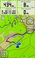
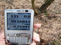
| + | Image:2011-03-01_50_8_HashPoint_reached.jpg | Hash-Point reached. | ||
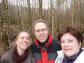
| + | Image:2011-03-01_50_8_HashPoint.jpg | All of us. ;-) | ||
| + | Image:2011-03-01_50_8_swamp.jpg | Swamp ... | ||
| + | Image:2011-03-01_50_8_in_the_woods.jpg | ... in the woods. | ||
| + | Image:2011-03-01_50_8_smile.jpg | Happy that we made it through the swamp. | ||
</gallery> | </gallery> | ||
== Achievements == | == Achievements == | ||
{{#vardefine:ribbonwidth|800px}} | {{#vardefine:ribbonwidth|800px}} | ||
| − | + | {{Land geohash | |
| − | + | | latitude = 50 | |
| − | + | | longitude = 8 | |
| − | + | | date = 2011-03-01 | |
| − | + | | name = QuarterCacher, M and LadyBB | |
| − | + | }} | |
| − | |||
| − | |||
| − | |||
| − | |||
| − | |||
[[Category:Expeditions]] | [[Category:Expeditions]] | ||
| − | |||
[[Category:Expeditions with photos]] | [[Category:Expeditions with photos]] | ||
| − | |||
| − | |||
| − | |||
| − | |||
| − | |||
[[Category:Coordinates reached]] | [[Category:Coordinates reached]] | ||
| − | + | {{location|DE|HE|SWA}} | |
| − | |||
| − | |||
| − | |||
| − | |||
| − | |||
| − | |||
| − | |||
| − | |||
| − | |||
Latest revision as of 05:41, 9 August 2019
| Tue 1 Mar 2011 in 50,8: 50.1684084, 8.2594597 geohashing.info google osm bing/os kml crox |
Location
In the forrest near Engenhahn / Taunus.
Participants
- QuarterCacher, M and LadyBB.
Plans
Meet near the hash point after work.
Expedition
Was held up at work longer than planned so went home, had a quick coffee with M, grabbed my Clogging stuff and drove to the meeting point. LadyBB arrived there just a few minutes before we did, so we could go straight to the hash point (we were a bit in a hurry). To our surprise we had to go downhill quite steep just to go straight up again. The hash point lay in a really muddy area, almost like a swamp. Luckily we mad it withour ruining our clothes. ;-) As I was running out of time we had to go straight back to the car and just made it in time for the Clogging beginner's class that I'm giving in Oberjosbach on Tuesdays at the moment.
Photos
Hash-Point reached.
All of us. ;-)
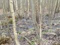
Swamp ...
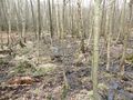
... in the woods.
Happy that we made it through the swamp.


Achievements
QuarterCacher, M and LadyBB earned the Land geohash achievement
|