Difference between revisions of "2011-05-08 50 7"
imported>Mampfred (Created page with "{{subst:Expedition |lat = 50 |lon = 7 |date = 2011-05-08 }}") |
imported>FippeBot m (Location) |
||
| (3 intermediate revisions by one other user not shown) | |||
| Line 1: | Line 1: | ||
| − | |||
| − | |||
| − | |||
| − | |||
| − | |||
| − | |||
| − | |||
| − | |||
| − | |||
| − | |||
{{meetup graticule | {{meetup graticule | ||
| lat=50 | | lat=50 | ||
| Line 15: | Line 5: | ||
}} | }} | ||
| − | |||
__NOTOC__ | __NOTOC__ | ||
== Location == | == Location == | ||
| − | + | In the woods near Winden. | |
== Participants == | == Participants == | ||
| − | + | *[[User:Mampfred|Mampfred]] | |
| + | *[[User:QuarterCacher|QuarterCacher]] | ||
== Plans == | == Plans == | ||
| − | + | ... coming from [[2011-05-07 50 7]] drive by and make it a midnight hash :) | |
== Expedition == | == Expedition == | ||
| − | + | After having a little problem with our car gps from [[2011-05-07 50 7|the first hash of the night]] (great idea to take the first town you find with a given name rather than giving you a selection list, grrr, probably have to rtfm) we arrived at the second hash area for the night around 11:15pm. By nowit was pretty much pitch black outside, no moon, no citylights anywhere nearby. | |
| + | |||
| + | As you can see from the track log we for some reason chose to park at the "wrong" street that was a lot further away from the hash than necessary. Started off anyway and smashed our way through some underwood before finding a proper track. Followed that for a while and in the end had to climb back up towards the street to the hash - pretty much in time for the midnight hash :) | ||
| + | |||
| + | Snapped a couple of pictures and headed back the same way we came - at least where we could find it as some evil person had suddenly put up a thick new tree nursery (?)in the middle of the track - or we took a wrong turn, but it's probably the first one. Car demanded some oil, fixed that and headed back home. A mere 2km walk that felt twice as long as the 2.8km walk for the first hash. | ||
| + | |||
| + | Got back home around 2:45pm, see you at the next hash night :) | ||
== Tracklog == | == Tracklog == | ||
| − | + | ===Mampfred=== | |
| + | See [http://www.everytrail.com/view_trip.php?trip_id=1080929 here]. | ||
== Photos == | == Photos == | ||
| − | + | ([[User:QuarterCacher|QuarterCacher]] took the good ones, it usually takes a while to get these online ;) | |
| − | + | ===Mampfred=== | |
| − | |||
<gallery perrow="5"> | <gallery perrow="5"> | ||
| + | Image:2011-05-08_50_7_coordinates.jpg | Coordinates ... | ||
| + | Image:2011-05-08_50_7_reached.jpg | ... reached. | ||
</gallery> | </gallery> | ||
== Achievements == | == Achievements == | ||
{{#vardefine:ribbonwidth|800px}} | {{#vardefine:ribbonwidth|800px}} | ||
| − | + | {{Land geohash | |
| + | | latitude = 50 | ||
| + | | longitude = 7 | ||
| + | | date = 2011-05-08 | ||
| + | | name = [[User:QuarterCacher|QuarterCacher]] and [[User:Mampfred|Mampfred]] | ||
| + | }} | ||
| + | {{Midnight_geohash | ||
| + | | latitude = 50 | ||
| + | | longitude = 7 | ||
| + | | date = 2011-05-08 | ||
| + | | name = [[User:QuarterCacher|QuarterCacher]] and [[User:Mampfred|Mampfred]] | ||
| + | }} | ||
| + | {{Consecutive_geohash | ||
| + | | latitude = 50 | ||
| + | | longitude = 7 | ||
| + | | count = 2 | ||
| + | | date = 2011-05-07 | ||
| + | | name = [[User:QuarterCacher|QuarterCacher]] and [[User:Mampfred|Mampfred]] | ||
| + | }} | ||
| − | |||
| − | |||
| − | |||
| − | |||
| − | |||
| − | |||
| − | |||
| − | |||
| − | |||
| − | |||
| − | |||
[[Category:Expeditions]] | [[Category:Expeditions]] | ||
| − | |||
[[Category:Expeditions with photos]] | [[Category:Expeditions with photos]] | ||
| − | |||
| − | |||
| − | |||
| − | |||
| − | |||
[[Category:Coordinates reached]] | [[Category:Coordinates reached]] | ||
| − | + | {{location|DE|RP|EMS}} | |
| − | |||
| − | |||
| − | |||
| − | |||
| − | |||
| − | |||
| − | |||
| − | |||
| − | |||
Latest revision as of 06:27, 9 August 2019
| Sun 8 May 2011 in 50,7: 50.3313774, 7.8228147 geohashing.info google osm bing/os kml crox |
Location
In the woods near Winden.
Participants
Plans
... coming from 2011-05-07 50 7 drive by and make it a midnight hash :)
Expedition
After having a little problem with our car gps from the first hash of the night (great idea to take the first town you find with a given name rather than giving you a selection list, grrr, probably have to rtfm) we arrived at the second hash area for the night around 11:15pm. By nowit was pretty much pitch black outside, no moon, no citylights anywhere nearby.
As you can see from the track log we for some reason chose to park at the "wrong" street that was a lot further away from the hash than necessary. Started off anyway and smashed our way through some underwood before finding a proper track. Followed that for a while and in the end had to climb back up towards the street to the hash - pretty much in time for the midnight hash :)
Snapped a couple of pictures and headed back the same way we came - at least where we could find it as some evil person had suddenly put up a thick new tree nursery (?)in the middle of the track - or we took a wrong turn, but it's probably the first one. Car demanded some oil, fixed that and headed back home. A mere 2km walk that felt twice as long as the 2.8km walk for the first hash.
Got back home around 2:45pm, see you at the next hash night :)
Tracklog
Mampfred
See here.
Photos
(QuarterCacher took the good ones, it usually takes a while to get these online ;)
Mampfred
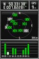
Coordinates ...
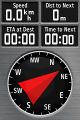
... reached.


Achievements
QuarterCacher and Mampfred earned the Land geohash achievement
|
QuarterCacher and Mampfred earned the Midnight Geohash achievement
|
QuarterCacher and Mampfred earned the Consecutive geohash achievement
|