Difference between revisions of "2011-06-23 49 8"
From Geohashing
imported>Mampfred |
imported>FippeBot m (Location) |
||
| (6 intermediate revisions by one other user not shown) | |||
| Line 11: | Line 11: | ||
== Participants == | == Participants == | ||
*[[User:Mampfred|Mampfred]] | *[[User:Mampfred|Mampfred]] | ||
| − | *[[User:LadyBB|LadyBB]] | + | *[[User:LadyBB|LadyBB]] (+MJ) |
| + | *[[User:QuarterCacher|QuarterCacher]] | ||
| + | *[[User:M|M]] | ||
| + | *[[User:Ricki|Ricki]] | ||
== Plans == | == Plans == | ||
| Line 17: | Line 20: | ||
== Expedition == | == Expedition == | ||
| − | + | Pretty straight forward. Thanks to the crop rotation the "field" turned out to be a strip of grass. We stopped on the way, walked down a track between fields for about a hundred meters, took some photos and headed back to the cars. Easy hash. | |
== Tracklog == | == Tracklog == | ||
| − | + | See [http://www.everytrail.com/view_trip.php?trip_id=1155458 here]. | |
== Photos == | == Photos == | ||
| − | |||
| − | |||
| − | |||
<gallery perrow="5"> | <gallery perrow="5"> | ||
| + | Image:2011-06-24_48_9_lets_go.jpg | Let's go! | ||
| + | Image:2011-06-24_48_9_close.jpg | Close! | ||
| + | Image:2011-06-24_48_9_closer.jpg | Closer!! | ||
| + | Image:2011-06-24_48_9_coordinates.jpg | Coordinates ... | ||
| + | Image:2011-06-24_48_9_reached.jpg | ... reached. | ||
| + | Image:2011-06-24_48_9_quartercacher_and_ladybb.jpg | QuarterCacher and LadyBB | ||
| + | Image:2011-06-24_48_9_come_on.jpg | Come on, guys! | ||
| + | Image:2011-06-24_48_9_grin.jpg | Stupid grin (LadyBB, Mampfred, M, Ricki and QuarterCacher) | ||
</gallery> | </gallery> | ||
== Achievements == | == Achievements == | ||
{{#vardefine:ribbonwidth|800px}} | {{#vardefine:ribbonwidth|800px}} | ||
| + | {{Land geohash | ||
| + | | latitude = 49 | ||
| + | | longitude = 8 | ||
| + | | date = 2011-06-23 | ||
| + | | name = QuarterCacher, M, Ricki, LadyBB and Mampfred | ||
| + | }} | ||
| − | |||
| − | |||
| − | |||
[[Category:Expeditions]] | [[Category:Expeditions]] | ||
| − | |||
[[Category:Expeditions with photos]] | [[Category:Expeditions with photos]] | ||
| − | |||
| − | |||
| − | |||
| − | |||
| − | |||
[[Category:Coordinates reached]] | [[Category:Coordinates reached]] | ||
| − | + | {{location|DE|HE|OF}} | |
| − | |||
| − | |||
| − | |||
| − | |||
| − | |||
| − | |||
| − | |||
| − | |||
| − | |||
Latest revision as of 06:53, 9 August 2019
| Thu 23 Jun 2011 in 49,8: 49.9992710, 8.7492493 geohashing.info google osm bing/os kml crox |
Location
Field between Rodgau and Dreieich.
Participants
- Mampfred
- LadyBB (+MJ)
- QuarterCacher
- M
- Ricki
Plans
We're in Rodgau for the rest of the week and might visit the hash on our way there.
Expedition
Pretty straight forward. Thanks to the crop rotation the "field" turned out to be a strip of grass. We stopped on the way, walked down a track between fields for about a hundred meters, took some photos and headed back to the cars. Easy hash.
Tracklog
See here.
Photos
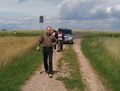
Let's go!
Close!
Closer!!
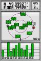
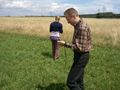
Coordinates ...
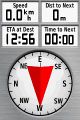
... reached.
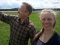
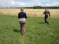
QuarterCacher and LadyBB
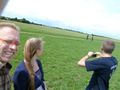
Come on, guys!
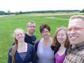
Stupid grin (LadyBB, Mampfred, M, Ricki and QuarterCacher)


Achievements
QuarterCacher, M, Ricki, LadyBB and Mampfred earned the Land geohash achievement
|