Difference between revisions of "2011-07-09 -25 28"
imported>Mithrandi (→Plans) |
m (per Renaming Proposal) |
||
| (6 intermediate revisions by 4 users not shown) | |||
| Line 25: | Line 25: | ||
[[User:Froztbyte|froztbyte]] | [[User:Froztbyte|froztbyte]] | ||
| + | |||
| + | potato | ||
| + | |||
| + | mciversa | ||
== Plans == | == Plans == | ||
| Line 30: | Line 34: | ||
== Expedition == | == Expedition == | ||
| − | + | mithrandi navigated to the location by car with the assistance of GPS, with froztbyte and potato riding along. Once there, we found a convenient parking spot in front of a nearby complex, and walked across the road to approximately where the spot should be. GPS reception was a little spotty, so we couldn't easily find the exact spot, but we got as close as technology would allow; the faint strains of music drifting over provided an unexpected backing soundtrack for the whole event. We stood around chatting for a bit, and were pleasantly surprised when mciversa drove up to join us unannounced. Unfortunately we didn't have any other geohashers show up, so after hanging around a little longer, we departed again to get breakfast/lunch/dinner/whatever. | |
| − | |||
| − | |||
| − | |||
== Photos == | == Photos == | ||
| − | |||
| − | |||
| − | |||
<gallery perrow="5"> | <gallery perrow="5"> | ||
| + | |||
| + | Image:2011-07-09_-25_28_16-06-56-613.jpg | The most boring spot in Pretoria. [http://www.openstreetmap.org/?lat=-25.82812556&lon=28.32119975&zoom=16&layers=B000FTF @-25.8281,28.3212] | ||
| + | |||
| + | Image:2011-07-09_-25_28_16-13-29-066.jpg | The intrepid explorers. [http://www.openstreetmap.org/?lat=-25.82798355&lon=28.32146079&zoom=16&layers=B000FTF @-25.8280,28.3215] | ||
</gallery> | </gallery> | ||
== Achievements == | == Achievements == | ||
{{#vardefine:ribbonwidth|800px}} | {{#vardefine:ribbonwidth|800px}} | ||
| − | + | {{land geohash | |
| + | | latitude = -25 | ||
| + | | longitude = 28 | ||
| + | | date = 2011-07-09 | ||
| + | | name = mithrandi, froztbyte, potato, and mciversa | ||
| − | + | }} | |
| − | + | {{Earliest geohasher | |
| − | + | | latitude = -25 | |
| + | | longitude = 28 | ||
| + | | date = 2011-07-09 | ||
| + | | name = mithrandi, froztbyte, and potato | ||
| + | |||
| + | }} | ||
| + | {{Graticule unlocked | ||
| + | |||
| + | | latitude = -25 | ||
| + | | longitude = 28 | ||
| + | | date = 2011-07-09 | ||
| + | | name = mithrandi, froztbyte, potato, and mciversa | ||
| + | |||
| + | }} | ||
| − | |||
[[Category:Expeditions]] | [[Category:Expeditions]] | ||
| − | |||
[[Category:Expeditions with photos]] | [[Category:Expeditions with photos]] | ||
| − | |||
| − | |||
| − | |||
| − | |||
[[Category:Coordinates reached]] | [[Category:Coordinates reached]] | ||
| − | + | {{location|ZA|GP}} | |
| − | |||
| − | |||
| − | |||
| − | |||
| − | |||
| − | |||
| − | |||
| − | |||
| − | |||
Latest revision as of 05:52, 20 March 2024
| Sat 9 Jul 2011 in Pretoria: -25.8280813, 28.3211713 geohashing.info google osm bing/os kml crox |
Location
Practically on top of a road in Pretoria. I don't know the area at all, but it seems easily accessible.
Participants
potato
mciversa
Plans
Pitch up hopefully around 16:00, find the location (should be trivial), hang around for a while, then go get something to eat.
Expedition
mithrandi navigated to the location by car with the assistance of GPS, with froztbyte and potato riding along. Once there, we found a convenient parking spot in front of a nearby complex, and walked across the road to approximately where the spot should be. GPS reception was a little spotty, so we couldn't easily find the exact spot, but we got as close as technology would allow; the faint strains of music drifting over provided an unexpected backing soundtrack for the whole event. We stood around chatting for a bit, and were pleasantly surprised when mciversa drove up to join us unannounced. Unfortunately we didn't have any other geohashers show up, so after hanging around a little longer, we departed again to get breakfast/lunch/dinner/whatever.
Photos
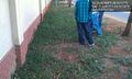
The most boring spot in Pretoria. @-25.8281,28.3212
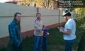
The intrepid explorers. @-25.8280,28.3215


Achievements
mithrandi, froztbyte, potato, and mciversa earned the Land geohash achievement
|
mithrandi, froztbyte, and potato earned the Earliest geohasher achievement
|
mithrandi, froztbyte, potato, and mciversa earned the Graticule Unlocked Achievement
|