Difference between revisions of "2011-07-15 44 -120"
From Geohashing
imported>Michael5000 (→Plans) |
imported>FippeBot m (Location) |
||
| (6 intermediate revisions by one other user not shown) | |||
| Line 1: | Line 1: | ||
| − | + | [[File:2011-07-15 44 -120 Truck.JPG|thumb|left|This was a drive-to hashpoint, but it was quite a drive.]] | |
| − | |||
| − | |||
| − | |||
| − | |||
| − | |||
| − | |||
| − | |||
{{meetup graticule | {{meetup graticule | ||
| lat=44 | | lat=44 | ||
| Line 26: | Line 19: | ||
*[[User:Mrs.5000|Mrs.5000]] | *[[User:Mrs.5000|Mrs.5000]] | ||
| − | == | + | |
| + | == Expedition == | ||
We had decided to take a short holiday to wherever the hashpoints sent us, and it was this easy but remote point that brought us to the Ochoco Mountains. Once in the area, it was not difficult to drive down a beautiful rural road, past the occasional cow, until the GPS confirmed we were in the right spot. | We had decided to take a short holiday to wherever the hashpoints sent us, and it was this easy but remote point that brought us to the Ochoco Mountains. Once in the area, it was not difficult to drive down a beautiful rural road, past the occasional cow, until the GPS confirmed we were in the right spot. | ||
Expedition Success. | Expedition Success. | ||
| − | |||
| − | |||
| − | |||
| − | |||
| − | |||
| − | |||
== Photos == | == Photos == | ||
| − | |||
| − | |||
| − | |||
<gallery perrow="5"> | <gallery perrow="5"> | ||
| + | File:2011-07-15 44 -120 Rimrock.JPG|A nice rock formation overlooking the hashpoint | ||
| + | File:2011-07-15 44 -120 Sun.JPG|Sunshine! | ||
| + | File:2011-07-15 44 -120 Truck.JPG|The truck enjoys a return to the dry half of Oregon | ||
| + | File:2011-07-15 44 -120 M5K.JPG|as does Michael5000 | ||
| + | File:2011-07-15 44 -120 Mrs.JPG|as does Mrs.5000 | ||
| + | File:2011-07-15 44 -120 Bear.JPG|as does their trusty ursine hashscot. | ||
</gallery> | </gallery> | ||
== Achievements == | == Achievements == | ||
{{#vardefine:ribbonwidth|800px}} | {{#vardefine:ribbonwidth|800px}} | ||
| − | |||
| − | |||
| − | |||
| − | |||
| − | |||
| − | |||
| − | |||
| − | |||
| − | |||
| − | |||
| − | |||
| − | |||
[[Category:Expeditions]] | [[Category:Expeditions]] | ||
| − | |||
[[Category:Expeditions with photos]] | [[Category:Expeditions with photos]] | ||
| − | |||
| − | |||
| − | |||
| − | |||
| − | |||
[[Category:Coordinates reached]] | [[Category:Coordinates reached]] | ||
| − | |||
| − | + | *Second known successful expedition in the Prineville graticule. | |
| − | + | *A new graticule for both Michael and Mrs.! | |
| − | + | {{location|US|OR|WE}} | |
| − | |||
| − | |||
| − | |||
| − | |||
| − | |||
Latest revision as of 00:05, 13 August 2019

| Fri 15 Jul 2011 in 44,-120: 44.7432928, -120.1710335 geohashing.info google osm bing/os kml crox |
Location
On Twickenham Road in Rural Wheeler County.
Participants
Expedition
We had decided to take a short holiday to wherever the hashpoints sent us, and it was this easy but remote point that brought us to the Ochoco Mountains. Once in the area, it was not difficult to drive down a beautiful rural road, past the occasional cow, until the GPS confirmed we were in the right spot.
Expedition Success.
Photos
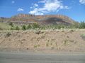
A nice rock formation overlooking the hashpoint
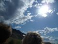
Sunshine!
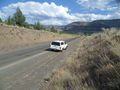
The truck enjoys a return to the dry half of Oregon

as does Michael5000
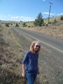
as does Mrs.5000
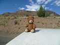
as does their trusty ursine hashscot.


Achievements
- Second known successful expedition in the Prineville graticule.
- A new graticule for both Michael and Mrs.!