Difference between revisions of "2011-07-16 44 -119"
imported>Michael5000 (→Expedition) |
imported>FippeBot m (Location) |
||
| (12 intermediate revisions by 2 users not shown) | |||
| Line 1: | Line 1: | ||
| − | |||
| − | |||
| − | |||
| − | |||
| − | |||
| − | |||
| − | |||
| − | |||
| − | |||
| − | |||
{{meetup graticule | {{meetup graticule | ||
| lat=44 | | lat=44 | ||
| Line 14: | Line 4: | ||
| date=2011-07-16 | | date=2011-07-16 | ||
}} | }} | ||
| − | |||
| − | |||
__NOTOC__ | __NOTOC__ | ||
== Location == | == Location == | ||
| Line 25: | Line 13: | ||
*[[User:Michael5000|Michael5000]] | *[[User:Michael5000|Michael5000]] | ||
*[[User:Mrs.5000|Mrs.5000]] | *[[User:Mrs.5000|Mrs.5000]] | ||
| − | |||
| − | |||
| − | |||
== Expedition == | == Expedition == | ||
| Line 40: | Line 25: | ||
Supposedly the same road, this one leaves Highway 26 some dozen miles to the west. On the map and from the air it looked like the most likely access route. However, immediately off the highway, nine miles from the hashpoint, we were denied a right of way. | Supposedly the same road, this one leaves Highway 26 some dozen miles to the west. On the map and from the air it looked like the most likely access route. However, immediately off the highway, nine miles from the hashpoint, we were denied a right of way. | ||
| + | |||
| + | [[File:2011-07-16 44 -119 sign.JPG|400 px]] | ||
| + | |||
| + | [[File:2011-07-16 44 -119 gate.JPG|400 px]] | ||
===National Forest Road 12=== | ===National Forest Road 12=== | ||
| Line 45: | Line 34: | ||
I was skeptical about this road, but it turned out to have several miles of good paved surface followed by a well-graded gravel surface. We passed through range country.... | I was skeptical about this road, but it turned out to have several miles of good paved surface followed by a well-graded gravel surface. We passed through range country.... | ||
| − | + | [[File:2011-07-16 44 -119 cows.JPG|400 px]] | |
...and into the National Forest, and were making excellent headway towards a distance where we could simply hike our way to the hashpoint. And then: | ...and into the National Forest, and were making excellent headway towards a distance where we could simply hike our way to the hashpoint. And then: | ||
| − | + | [[File:2011-07-16 44 -119 tire.JPG|400 px]] | |
Since we were not at all prepared to deal with this emergency in a safe fashion, we were in a bit of luck not only that another vehicle happened along a few minutes later -- quite a coincidence in itself -- but that it was driven by a friendly guy who had been a fleet maintenance manager for a large utility before he retired. Needless to say, he was more than able to walk us through the steps of changing over to the spare. | Since we were not at all prepared to deal with this emergency in a safe fashion, we were in a bit of luck not only that another vehicle happened along a few minutes later -- quite a coincidence in itself -- but that it was driven by a friendly guy who had been a fleet maintenance manager for a large utility before he retired. Needless to say, he was more than able to walk us through the steps of changing over to the spare. | ||
| Line 55: | Line 44: | ||
Unfortunately, since our priority was then to get back to blacktop as soon as possible, this first ever attempt on the Kimberly graticule had to be abandoned, just as it was starting to look doable. | Unfortunately, since our priority was then to get back to blacktop as soon as possible, this first ever attempt on the Kimberly graticule had to be abandoned, just as it was starting to look doable. | ||
| − | + | [[File:2011-07-16 44 -119 GPS.JPG|300 px]] | |
| − | + | ||
== Photos == | == Photos == | ||
| − | + | ||
| − | |||
| − | |||
<gallery perrow="5"> | <gallery perrow="5"> | ||
| + | File:2011-07-16 44 -119 sign.JPG|It was a friendly "git out" sign, as they go. | ||
| + | File:2011-07-16 44 -119 gate.JPG|And a very handsome gate! | ||
| + | File:2011-07-16 44 -119 cows.JPG|Moo | ||
| + | File:2011-07-16 44 -119 tire.JPG|Creve! | ||
| + | File:2011-07-16 44 -119 GPS.JPG|So Far, and yet so close. | ||
</gallery> | </gallery> | ||
== Achievements == | == Achievements == | ||
{{#vardefine:ribbonwidth|800px}} | {{#vardefine:ribbonwidth|800px}} | ||
| − | |||
| − | + | {{Train wreck | |
| − | + | | latitude = 44 | |
| − | + | | longitude = -119 | |
| + | | date = 2011-07-16 | ||
| + | | reason = due to a flat tire | ||
| + | | name = Michael5000 and Mrs.5000 | ||
| + | | image = 2011-07-16 44 -119 tire.JPG | ||
| + | }} | ||
| + | |||
| + | {{No trespassing | ||
| + | |||
| + | | latitude = 44 | ||
| + | | longitude = -119 | ||
| + | | date = 2011-07-16 | ||
| + | | name = Michael5000 and Mrs.5000 | ||
| + | | image = 2011-07-16 44 -119 sign.JPG | ||
| + | | distance = 9 miles | ||
| − | + | }} | |
| − | |||
| − | |||
| − | |||
| − | |||
[[Category:Expeditions]] | [[Category:Expeditions]] | ||
| − | |||
[[Category:Expeditions with photos]] | [[Category:Expeditions with photos]] | ||
| − | |||
| − | |||
| − | |||
| − | |||
| − | |||
| − | |||
| − | |||
| − | |||
| − | |||
[[Category:Coordinates not reached]] | [[Category:Coordinates not reached]] | ||
| − | + | [[Category:Not reached - No public access]] | |
| − | + | [[Category:Not reached - Technology]] | |
| − | [[Category:Not reached - No public access]] | + | {{location|US|OR|WE}} |
| − | [[Category:Not reached - Technology]] | ||
| − | |||
| − | |||
Latest revision as of 00:07, 13 August 2019
| Sat 16 Jul 2011 in 44,-119: 44.4212630, -119.8338070 geohashing.info google osm bing/os kml crox |
Location
Many miles off pavement in the Ochoco National Forest
Participants
Expedition
There were three possible roads to this very isolated hashpoint, but none of them looked at all like a sure thing. As it turned out, we gave all three of them a try.
Antone Road (east entrance)
This road, labelled a "Highway" at its intersection with U.S. 26, started off as a bold blacktop road but quickly turned to gravel. The quality of the grading deteriorated over five or six miles until, about 7 miles from the hashpoint, the road passed a large ranch compound and immediately deteriorated into a dirt track. Lacking bicycles or four wheel drive, we retreated.
Antone Road (west entrance)
Supposedly the same road, this one leaves Highway 26 some dozen miles to the west. On the map and from the air it looked like the most likely access route. However, immediately off the highway, nine miles from the hashpoint, we were denied a right of way.


National Forest Road 12
I was skeptical about this road, but it turned out to have several miles of good paved surface followed by a well-graded gravel surface. We passed through range country....

...and into the National Forest, and were making excellent headway towards a distance where we could simply hike our way to the hashpoint. And then:

Since we were not at all prepared to deal with this emergency in a safe fashion, we were in a bit of luck not only that another vehicle happened along a few minutes later -- quite a coincidence in itself -- but that it was driven by a friendly guy who had been a fleet maintenance manager for a large utility before he retired. Needless to say, he was more than able to walk us through the steps of changing over to the spare.
Unfortunately, since our priority was then to get back to blacktop as soon as possible, this first ever attempt on the Kimberly graticule had to be abandoned, just as it was starting to look doable.

Photos
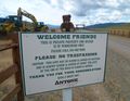
It was a friendly "git out" sign, as they go.
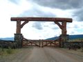
And a very handsome gate!
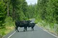
Moo
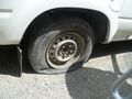
Creve!
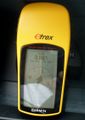
So Far, and yet so close.
Achievements
Michael5000 and Mrs.5000 earned the Train wreck consolation prize
|
Michael5000 and Mrs.5000 earned the No trespassing consolation prize
|