Difference between revisions of "2011-07-28 55 12"
imported>Bjuhn ([live picture] This will be a battle against time and the elements [http://www.openstreetmap.org/?lat=55.70682421&lon=12.53570175&zoom=16&layers=B000FTF @55.7068,12.5357]) |
imported>FippeBot m (Location) |
||
| (4 intermediate revisions by one other user not shown) | |||
| Line 1: | Line 1: | ||
| − | |||
| − | |||
| − | |||
| − | |||
| − | |||
| − | |||
| − | |||
| − | |||
| − | |||
| − | |||
{{meetup graticule | {{meetup graticule | ||
| lat=55 | | lat=55 | ||
| Line 15: | Line 5: | ||
}} | }} | ||
| − | |||
__NOTOC__ | __NOTOC__ | ||
== Location == | == Location == | ||
| − | + | Todays hash is located on a quiet residential street in southern Amager. | |
== Participants == | == Participants == | ||
| − | + | [[User:bjuhn|bjuhn]] dropped by for a brief visit after work | |
| − | |||
| − | |||
| − | |||
== Expedition == | == Expedition == | ||
| − | + | Observing that the hash was roughly within what could be described as a short detour off my way home from work, (at least, it was not in the entire opposite direction..) I decided to have a race with nature, to see if I could make the trip before it started to rain. Setting out on my trusty scooter (it has by now been over a month without it breaking down) I made it to the highway. After an uneventful drive, only interrupted by me having to empty out one tank and fill up another, I arrived at the hash, which was situated on an ordinary residential road. The smell of rain was in the air, so after taking a couple of quick photos, I headed home. I had only just made it in the door when the rain started. (me: 1, nature: 0) | |
| − | |||
| − | |||
| − | |||
== Photos == | == Photos == | ||
| − | |||
| − | |||
| − | |||
<gallery perrow="5"> | <gallery perrow="5"> | ||
| + | Image:2011-07-28_55_12_18-33-17-990.jpg | This will be a battle against time and the elements | ||
| − | Image:2011-07-28_55_12_18- | + | Image:2011-07-28_55_12_18-41-09-295.jpg | 5km to go, the elements are catching up... as were nature |
| + | |||
| + | Image:2011-07-28_55_12_18-43-11-777.jpg | Parked on the spot :) | ||
| + | |||
| + | Image:2011-07-28_55_12_18-46-25-505.jpg | Congratulatory smirky smile | ||
</gallery> | </gallery> | ||
| Line 46: | Line 31: | ||
| − | |||
| − | |||
| − | |||
| − | |||
| − | |||
| − | |||
| − | |||
| − | |||
| − | |||
| − | |||
[[Category:Expeditions]] | [[Category:Expeditions]] | ||
| − | |||
[[Category:Expeditions with photos]] | [[Category:Expeditions with photos]] | ||
| − | |||
| − | |||
| − | |||
| − | |||
| − | |||
[[Category:Coordinates reached]] | [[Category:Coordinates reached]] | ||
| − | + | {{location|DK|84}} | |
| − | |||
| − | |||
| − | |||
| − | |||
| − | |||
| − | |||
| − | |||
| − | |||
| − | |||
Latest revision as of 00:17, 13 August 2019
| Thu 28 Jul 2011 in 55,12: 55.5918538, 12.5768172 geohashing.info google osm bing/os kml crox |
Location
Todays hash is located on a quiet residential street in southern Amager.
Participants
bjuhn dropped by for a brief visit after work
Expedition
Observing that the hash was roughly within what could be described as a short detour off my way home from work, (at least, it was not in the entire opposite direction..) I decided to have a race with nature, to see if I could make the trip before it started to rain. Setting out on my trusty scooter (it has by now been over a month without it breaking down) I made it to the highway. After an uneventful drive, only interrupted by me having to empty out one tank and fill up another, I arrived at the hash, which was situated on an ordinary residential road. The smell of rain was in the air, so after taking a couple of quick photos, I headed home. I had only just made it in the door when the rain started. (me: 1, nature: 0)
Photos
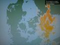
This will be a battle against time and the elements
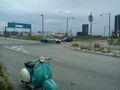
5km to go, the elements are catching up... as were nature
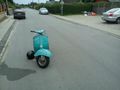
Parked on the spot :)

Congratulatory smirky smile


