Difference between revisions of "2011-08-22 45 -92"
imported>RocketMac (Created page with "<!-- If you did not specify these parameters in the template, please substitute appropriate values for IMAGE, LAT, LON, and DATE (YYYY-MM-DD format) [[Image:{{{image|IMAGE}}}|t...") |
imported>FippeBot m (Location) |
||
| (2 intermediate revisions by 2 users not shown) | |||
| Line 35: | Line 35: | ||
I didn't even see they were standing there. | I didn't even see they were standing there. | ||
| − | + | Suddenly, I heard a voice in the distance. I looked out and saw two people standing down the driveway by the farmhouse. Even with my hearing aids, it was hard to make out, but they were asking if I was there to see the place. It was for sale. I simply explained that I was following my GPS (which was true) and after seeing the view had to take some pictures. They nodded and seemed content, so I took a few more pictures, took a GPS map of the distance and points and moved on. | |
The next stretch between points four and five were full of some gorgeous countryside. This included reaching the top of a small incline to find myself heading nearly straight down a long, steep decline. I managed to stop and get some pictures, but sadly the perspective is lost on (digital) film. | The next stretch between points four and five were full of some gorgeous countryside. This included reaching the top of a small incline to find myself heading nearly straight down a long, steep decline. I managed to stop and get some pictures, but sadly the perspective is lost on (digital) film. | ||
| Line 43: | Line 43: | ||
== Tracklog == | == Tracklog == | ||
My log for the whole day is available in [http://coldshadow.com/geohashing/2011-08-22.gpx GPX] and [http://coldshadow.com/geohashing/2011-08-22.kmz KMZ] formats | My log for the whole day is available in [http://coldshadow.com/geohashing/2011-08-22.gpx GPX] and [http://coldshadow.com/geohashing/2011-08-22.kmz KMZ] formats | ||
| − | |||
| − | == Photos == | + | |
| + | |||
| + | == Photos == | ||
| + | |||
<gallery perrow="5"> | <gallery perrow="5"> | ||
Image:2011-08-22_45_-92_01.png | So close... | Image:2011-08-22_45_-92_01.png | So close... | ||
| Line 55: | Line 57: | ||
== Achievements == | == Achievements == | ||
| + | {{#vardefine:ribbonwidth|800px}} | ||
{{No trespassing | {{No trespassing | ||
| − | | latitude = | + | | latitude = 45 |
| − | | longitude = - | + | | longitude = -92 |
| date = 2011-08-22 | | date = 2011-08-22 | ||
| name = RocketMac | | name = RocketMac | ||
| Line 64: | Line 67: | ||
}} | }} | ||
| − | + | [[Category:Expeditions with photos]] | |
| − | |||
| − | |||
| − | |||
| − | |||
| − | |||
| − | [[Category: | ||
| − | |||
| − | |||
| − | |||
| − | |||
| − | |||
| − | |||
| − | |||
[[Category:Expeditions]] | [[Category:Expeditions]] | ||
| − | |||
| − | |||
| − | |||
| − | |||
| − | + | [[Category:Not reached - No public access]] | |
| − | [[Category: | ||
| − | |||
| − | |||
| − | |||
[[Category:Coordinates not reached]] | [[Category:Coordinates not reached]] | ||
| − | + | {{location|US|WI|DN}} | |
| − | |||
| − | |||
| − | |||
| − | |||
Latest revision as of 00:34, 13 August 2019
| Mon 22 Aug 2011 in 45,-92: 45.0079141, -92.0222607 geohashing.info google osm bing/os kml crox |
Location
A stretch of rolling green and woods on a private farmland.
Participants
RocketMac - On my way from Milwaukee to Minneapolis for work
Plans
Normally when I drive for work, I plan out a few Geocaches along the way to break up the driving and snag a few finds. This time, I realized that I would be passing through multiple graticules and five of them had hashpoints I could reach with only a slight detour.
In the full spirit of adventure, I let The Algorithm be the wind in my sails and the GPS satellites my stars. I just let them guide me from one hashpoint to another taking routes I never would have tried before and seeing all new sights.
Expedition
This was the fourth of five for the day. The last couple of graticules I passed through had hashpoints way too far off my path. I had considered skipping this one as it was getting later in the afternoon. Looking at the point on Google Maps I was concerned I wouldn't be able to get to it.
I had already looked at the fifth point on Google and knew that I would have no problem with it even at night. So, in the spirit of adventure, I decided to give number four a try.
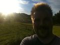
As soon as I pulled up, I knew I wasn't going to make the exact point. It was clearly on private property and wide open. Making any movement in the direction would be immediately obvious to anyone including the owners. I started taking pictures instead.
I didn't even see they were standing there.
Suddenly, I heard a voice in the distance. I looked out and saw two people standing down the driveway by the farmhouse. Even with my hearing aids, it was hard to make out, but they were asking if I was there to see the place. It was for sale. I simply explained that I was following my GPS (which was true) and after seeing the view had to take some pictures. They nodded and seemed content, so I took a few more pictures, took a GPS map of the distance and points and moved on.
The next stretch between points four and five were full of some gorgeous countryside. This included reaching the top of a small incline to find myself heading nearly straight down a long, steep decline. I managed to stop and get some pictures, but sadly the perspective is lost on (digital) film.
Number five was going to be easy, so it was time to get going.
Tracklog
My log for the whole day is available in GPX and KMZ formats
Photos
So close...
The hashpoint is somewhere back there
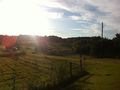
The countryside to the other side of the farm. Very pretty
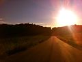
May not look like it but that is one steep hill


Achievements
RocketMac earned the No trespassing consolation prize
|