Difference between revisions of "2011-08-29 global"
imported>LoneTech ([live picture] Roos, gnitset and lonetech at the globalhash! [http://www.openstreetmap.org/?lat=60.66551077&lon=15.8798913&zoom=16&layers=B000FTF @60.6655,15.8799]) |
imported>Fippe |
||
| (8 intermediate revisions by 3 users not shown) | |||
| Line 5: | Line 5: | ||
And DON'T FORGET to add your expedition and the best photo you took to the gallery on the Main Page! We'd love to read your report, but that means we first have to discover it! | And DON'T FORGET to add your expedition and the best photo you took to the gallery on the Main Page! We'd love to read your report, but that means we first have to discover it! | ||
--> | --> | ||
| + | |||
| + | |||
| + | {{meetup global|date=2011-08-29}} | ||
| + | |||
| + | |||
| + | |||
<table class="infobox" style="width: 22em; text-align: left; font-size: 88%; line-height: 1.5em; border: 1px solid rgb(170, 170, 170); background-color: rgb(249, 249, 249); color: black; margin: 0.5em 0pt 0.5em 1em; padding: 0.2em; float: right; clear: right;" cellspacing="5"> | <table class="infobox" style="width: 22em; text-align: left; font-size: 88%; line-height: 1.5em; border: 1px solid rgb(170, 170, 170); background-color: rgb(249, 249, 249); color: black; margin: 0.5em 0pt 0.5em 1em; padding: 0.2em; float: right; clear: right;" cellspacing="5"> | ||
<tr> | <tr> | ||
| Line 10: | Line 16: | ||
<p>[[2011-08-29|Mon Aug 29 2011]] Globalhash:<br /> | <p>[[2011-08-29|Mon Aug 29 2011]] Globalhash:<br /> | ||
'''60.66553154°, 15.87988360°'''<br /> | '''60.66553154°, 15.87988360°'''<br /> | ||
| − | [http://www.drwilco.net/globalhash/map.html?date=2011-08-29&zoom=8&abs=1 drwilco] [http://maps.google.com/maps?f=q&hl=en&q=60.66553153786134,+15.879883597320969+%28Globalhash+for+29+Aug+2011%29&ie=UTF8&t=h google] [http://www.openstreetmap.org/?mlat=60.66553153786134&mlon=15.879883597320969&zoom=16&layers=B000FTF osm] | + | |
| + | <!-- BROKEN [http://www.drwilco.net/globalhash/map.html?date=2011-08-29&zoom=8&abs=1 drwilco] --> | ||
| + | |||
| + | [http://maps.google.com/maps?f=q&hl=en&q=60.66553153786134,+15.879883597320969+%28Globalhash+for+29+Aug+2011%29&ie=UTF8&t=h google] [http://www.openstreetmap.org/?mlat=60.66553153786134&mlon=15.879883597320969&zoom=16&layers=B000FTF osm] | ||
</p> | </p> | ||
</td> | </td> | ||
| Line 16: | Line 25: | ||
</table> | </table> | ||
| − | + | ||
__NOTOC__ | __NOTOC__ | ||
== Location == | == Location == | ||
| − | + | ||
| + | Sweden! Or to be more precise, in a forested bog near Falun, Dalarna. | ||
== Participants == | == Participants == | ||
| − | + | ||
| + | * Roos | ||
| + | * gnitset | ||
| + | * [[User:LoneTech|Yann Vernier]] | ||
| + | |||
== Plans == | == Plans == | ||
| − | + | ||
| + | As usual with Yann's plans, there was not much to it. It started with Roos recommending c:geo for his new phone, escalated with an installation of Geohash Droid, and then a Swedish globalhash for a Monday was noticed the Friday before. A few calls around, Gnitset chose to drive as well as provide the car, a day off work was negotiated, Roos came along, and off we went. With bananas. | ||
== Expedition == | == Expedition == | ||
| − | + | ||
| + | It pretty much started with the weekend. I (Yann) had a lack of plans and went along to some sort of festival where Roos and Gnitset were taking photographs; as we found a hatter, we purchased hats. Minor adventures were generated, and we somehow ended up with quite a few bananas. | ||
| + | |||
| + | On Monday, we slept in until around ten o'clock, when we were joined by Roos, then departed by car. With the idea of a multihash spawned by the sheer length of the trip, we actually took a detour to visit the [[2011-08-29 59 17|Uppsala graticule geohash]]. It was found without much trouble, but using some paths that could only generously be considered roads. | ||
| + | |||
| + | We then continued to the Falun region, and used a combination of good cheer, vague memory, online maps, and a route planning program to reach the vicinity of the Globalhash. We picked up a pizza on the way to improve our picnic, as only bananas wouldn't satisfy us much. As we turned into the road closest to our hash, we found it was little trafficked.. probably only by forestry gear again, as there were some piles of timber, but no space to turn. At least not until we reached the end, where the GPS loudly announced "Turn around." We were expecting it to announce arrival, and so this drew a considerable amount of laughter. | ||
| + | |||
| + | We continued south from that spot, at first following the tracks of a machine but soon losing them, into the bog. This type of territory is fairly interesting; you never know where the ground will be firm, and anywhere it isn't, you get wet. To top that off, Roos had chosen sandals for the day. Some perseverance sufficed to get us to the proper spot, and there was cheering, picture taking, pizza and bananas. At one point Gnitset tossed a banana at me, which I failed to catch, and we decided to share the bananas with the forest. | ||
| + | |||
| + | On our way back, we tried to visit the Sala graticule hash too, but it was fairly far out in a very muddy field. In the interest of making the world a stranger place, we gave the remaining bananas to a gentleman who did not expect visitors. | ||
== Tracklog == | == Tracklog == | ||
| − | + | ||
| + | [http://donkey.vernier.se/~yann/geohashing/W20110829112533.gpx GPX] | ||
== Photos == | == Photos == | ||
| − | + | ||
| − | |||
| − | |||
<gallery perrow="4"> | <gallery perrow="4"> | ||
| Line 43: | Line 66: | ||
| − | |||
| − | |||
| − | |||
| − | |||
| − | |||
| − | |||
| − | |||
| − | |||
[[Category:Expeditions]] | [[Category:Expeditions]] | ||
| − | |||
[[Category:Expeditions with photos]] | [[Category:Expeditions with photos]] | ||
| − | |||
| − | |||
| − | |||
| − | |||
| − | |||
[[Category:Coordinates reached]] | [[Category:Coordinates reached]] | ||
| − | + | [[Category:Meetup in 60 15]] | |
| − | |||
| − | |||
| − | |||
| − | |||
| − | |||
| − | |||
| − | |||
| − | [[Category: | ||
| − | |||
[[Category:Meetup on 2011-08-29]] | [[Category:Meetup on 2011-08-29]] | ||
[[Category:Globalhash]] | [[Category:Globalhash]] | ||
| + | {{location|SE|W}} | ||
Latest revision as of 18:18, 8 August 2019
|
Globalhash on Mon 29 Aug 2011: |
|
Mon Aug 29 2011 Globalhash: |
Location
Sweden! Or to be more precise, in a forested bog near Falun, Dalarna.
Participants
- Roos
- gnitset
- Yann Vernier
Plans
As usual with Yann's plans, there was not much to it. It started with Roos recommending c:geo for his new phone, escalated with an installation of Geohash Droid, and then a Swedish globalhash for a Monday was noticed the Friday before. A few calls around, Gnitset chose to drive as well as provide the car, a day off work was negotiated, Roos came along, and off we went. With bananas.
Expedition
It pretty much started with the weekend. I (Yann) had a lack of plans and went along to some sort of festival where Roos and Gnitset were taking photographs; as we found a hatter, we purchased hats. Minor adventures were generated, and we somehow ended up with quite a few bananas.
On Monday, we slept in until around ten o'clock, when we were joined by Roos, then departed by car. With the idea of a multihash spawned by the sheer length of the trip, we actually took a detour to visit the Uppsala graticule geohash. It was found without much trouble, but using some paths that could only generously be considered roads.
We then continued to the Falun region, and used a combination of good cheer, vague memory, online maps, and a route planning program to reach the vicinity of the Globalhash. We picked up a pizza on the way to improve our picnic, as only bananas wouldn't satisfy us much. As we turned into the road closest to our hash, we found it was little trafficked.. probably only by forestry gear again, as there were some piles of timber, but no space to turn. At least not until we reached the end, where the GPS loudly announced "Turn around." We were expecting it to announce arrival, and so this drew a considerable amount of laughter.
We continued south from that spot, at first following the tracks of a machine but soon losing them, into the bog. This type of territory is fairly interesting; you never know where the ground will be firm, and anywhere it isn't, you get wet. To top that off, Roos had chosen sandals for the day. Some perseverance sufficed to get us to the proper spot, and there was cheering, picture taking, pizza and bananas. At one point Gnitset tossed a banana at me, which I failed to catch, and we decided to share the bananas with the forest.
On our way back, we tried to visit the Sala graticule hash too, but it was fairly far out in a very muddy field. In the interest of making the world a stranger place, we gave the remaining bananas to a gentleman who did not expect visitors.
Tracklog
Photos
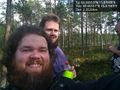
Roos, gnitset and lonetech at the globalhash! @60.6655,15.8799
