Difference between revisions of "2011-09-01 40 -74"
From Geohashing
imported>Jevanyn ([live picture] South over I287 overpass [http://www.openstreetmap.org/?lat=40.5716&lon=-74.5618&zoom=16&layers=B000FTF @40.5716,-74.5618]) |
imported>FippeBot m (Location) |
||
| (5 intermediate revisions by 2 users not shown) | |||
| Line 1: | Line 1: | ||
| − | |||
<!-- If you did not specify these parameters in the template, please substitute appropriate values for IMAGE, LAT, LON, and DATE (YYYY-MM-DD format) | <!-- If you did not specify these parameters in the template, please substitute appropriate values for IMAGE, LAT, LON, and DATE (YYYY-MM-DD format) | ||
| Line 15: | Line 14: | ||
}} | }} | ||
| − | + | ||
__NOTOC__ | __NOTOC__ | ||
== Location == | == Location == | ||
| − | + | Chimney Rock Rd., Bound Brook / Bridgewater. | |
== Participants == | == Participants == | ||
| − | |||
| − | + | * [[User:Jevanyn|Jevanyn]] | |
| − | + | ||
| + | |||
== Expedition == | == Expedition == | ||
<!-- how it all turned out. your narrative goes here. --> | <!-- how it all turned out. your narrative goes here. --> | ||
| − | + | ||
| − | + | *After spending most of the day packing for a trip to [[Cape May]], I check the geohash at 11:15 and it's ''right around the corner'', 2 miles away. I had just enough time to get there by midnight, upload the pictures, then drive 2+ hours to my wife's aunt's place, where we often stay when down for the weekend. -- [[User:Jevanyn|Jevanyn]] 09:02, 02 September 2011 (EDT) | |
== Photos == | == Photos == | ||
| − | + | ||
| − | + | <gallery> | |
| − | |||
| − | <gallery | ||
Image:2011-09-01_40_-74_23-35-25-243.jpg | Hydrant within 5 feet of geohash [http://www.openstreetmap.org/?lat=40.5685&lon=-74.5545&zoom=16&layers=B000FTF @40.5685,-74.5545] | Image:2011-09-01_40_-74_23-35-25-243.jpg | Hydrant within 5 feet of geohash [http://www.openstreetmap.org/?lat=40.5685&lon=-74.5545&zoom=16&layers=B000FTF @40.5685,-74.5545] | ||
| Line 45: | Line 42: | ||
== Achievements == | == Achievements == | ||
{{#vardefine:ribbonwidth|800px}} | {{#vardefine:ribbonwidth|800px}} | ||
| − | |||
| + | * Land Geohash | ||
| − | |||
| − | |||
| − | |||
| − | + | [[Category:Expeditions]] | |
| − | |||
| − | [[Category: | ||
| − | |||
| − | |||
| − | |||
| − | |||
[[Category:Expeditions with photos]] | [[Category:Expeditions with photos]] | ||
| − | + | ||
| − | |||
| − | |||
| − | |||
| − | |||
[[Category:Coordinates reached]] | [[Category:Coordinates reached]] | ||
| − | + | [[Category:Jevanyn/brought Gwynnath]] | |
| − | + | [[Category:Jevanyn/brought Evan]] | |
| − | + | [[Category:Jevanyn/brought Grace]] | |
| − | [[Category: | + | {{location|US|NJ|SO}} |
| − | |||
| − | [[Category: | ||
| − | [[Category: | ||
| − | |||
| − | |||
| − | |||
Latest revision as of 00:42, 13 August 2019
| Thu 1 Sep 2011 in 40,-74: 40.5715489, -74.5618880 geohashing.info google osm bing/os kml crox |
Location
Chimney Rock Rd., Bound Brook / Bridgewater.
Participants
Expedition
- After spending most of the day packing for a trip to Cape May, I check the geohash at 11:15 and it's right around the corner, 2 miles away. I had just enough time to get there by midnight, upload the pictures, then drive 2+ hours to my wife's aunt's place, where we often stay when down for the weekend. -- Jevanyn 09:02, 02 September 2011 (EDT)
Photos

Hydrant within 5 feet of geohash @40.5685,-74.5545
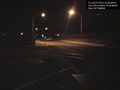
South over I287 overpass @40.5716,-74.5618


Achievements
- Land Geohash