Difference between revisions of "2011-09-11 48 8"
From Geohashing
imported>Ekorren (Been there. Report might be done later.) |
imported>FippeBot m (Location) |
||
| (One intermediate revision by one other user not shown) | |||
| Line 19: | Line 19: | ||
== Gallery == | == Gallery == | ||
<gallery> | <gallery> | ||
| + | File:2011-09-11_48_8_Train.JPG|Vintage MAN DMU that brought me to Rangendingen | ||
| + | File:2011-09-11_48_8_Road.JPG|Road up | ||
| + | File:2011-09-11_48_8_CastleHohenzollern.JPG|Obligatory Castle Hohenzollern view (also a view on hash forest) | ||
| + | File:2011-09-11_48_8_KZ_Cemetery.JPG|Cemetery of Nazi Concentration Camp victims | ||
| + | File:2011-09-11_48_8_Private_Entrance.JPG|The hash is behind this property. No way this way. | ||
| + | File:2011-09-11_48_8_GPS_FirstTry.JPG|Not quite close enough... | ||
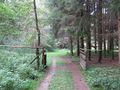
| + | File:2011-09-11_48_8_WayToHash.JPG|This Is A Way (according to the map) | ||
| + | File:2011-09-11_48_8_Bridge.JPG|Bridge to the hashpoint | ||
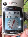
| + | File:2011-09-11_48_8_GPS.JPG|Coordinates reached | ||
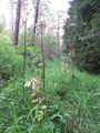
| + | File:2011-09-11_48_8_HashNettles.JPG|Dominant vegetation at hash: Stinging nettles. Ouch! | ||
| + | File:2011-09-11_48_8_VFH.JPG|View from hash | ||
| + | File:2011-09-11_48_8_VFH_up.JPG|View from hash | ||
| + | File:2011-09-11_48_8_cloverleaf.JPG|Dominant vegetation in hash forest: Cloverleaf | ||
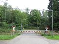
| + | File:2011-09-11_48_8_Call_a_crossing.JPG|Level crossing closed: | ||
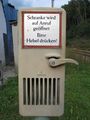
| + | File:2011-09-11_48_8_ClosedCrossing.JPG|<i>Barrier is opened on call. Please press lever.</i> | ||
</gallery> | </gallery> | ||
[[Category:Expeditions]] | [[Category:Expeditions]] | ||
[[Category:Expeditions with photos]] | [[Category:Expeditions with photos]] | ||
[[Category:Coordinates reached]] | [[Category:Coordinates reached]] | ||
| + | {{location|DE|BW|BL}} | ||
Latest revision as of 00:48, 13 August 2019
| Sun 11 Sep 2011 in 48,8: 48.3321399, 8.9189641 geohashing.info google osm bing/os kml crox |
Contents
Location
Bisingen, deep in a valley in a forest
Participants
Ekorren was there.
Expedition
Report might be done later
Gallery
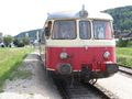
Vintage MAN DMU that brought me to Rangendingen
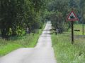
Road up
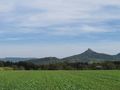
Obligatory Castle Hohenzollern view (also a view on hash forest)
Cemetery of Nazi Concentration Camp victims
The hash is behind this property. No way this way.
Not quite close enough...
This Is A Way (according to the map)
Bridge to the hashpoint
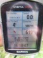
Coordinates reached
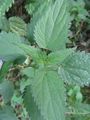
Dominant vegetation at hash: Stinging nettles. Ouch!
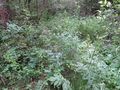
View from hash
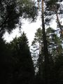
View from hash
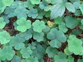
Dominant vegetation in hash forest: Cloverleaf
Level crossing closed:
Barrier is opened on call. Please press lever.


