Difference between revisions of "2011-09-19 44 -119"
imported>Michael5000 m (→Achievements) |
imported>FippeBot m (Location) |
||
| (8 intermediate revisions by 2 users not shown) | |||
| Line 11: | Line 11: | ||
== Location == | == Location == | ||
| − | + | On a hill overlooking the John Day Valley west of Mount Vernon. | |
== Participants == | == Participants == | ||
| Line 20: | Line 20: | ||
== Expedition == | == Expedition == | ||
| − | + | This easy-looking hashpoint turned out to be a disappointment. On the map it is a very short drive off of U.S. Highway 26, but the road in question is private -- someone's driveway, really. I tried the direct approach of hiking straight up the slope, but it quickly became too steep to continue. This was actually a bit of a relief, since behaving strangely right next to a major road always makes me feel a little awkward. Call me crazy. | |
| + | |||
| + | Having only one success against two failures for the day, I continued west on U.S. 26 feeling a bit defeated. The day's final three hashpoints, however, would all be successes. | ||
== Photos == | == Photos == | ||
| − | |||
| − | |||
| − | |||
<gallery perrow="5"> | <gallery perrow="5"> | ||
| + | File:2011-09-19 44 -119 main.JPG|Private Road | ||
| + | File:2011-09-19 44 -119 2.JPG|VERY private road | ||
| + | File:2011-09-19 44 -119 3.JPG|I made an effort of getting up this hill, but I'm glad I gave up; the hashpoint still would have been out of reach. | ||
</gallery> | </gallery> | ||
| Line 33: | Line 35: | ||
{{#vardefine:ribbonwidth|800px}} | {{#vardefine:ribbonwidth|800px}} | ||
<!-- Add any achievement ribbons you earned below, or remove this section --> | <!-- Add any achievement ribbons you earned below, or remove this section --> | ||
| + | |||
| + | |||
| + | {{No trespassing | ||
| + | | latitude = 44 | ||
| + | | longitude = -119 | ||
| + | | date = 2011-09-19 | ||
| + | | name = [[User:Michael5000|Michael5000]] | ||
| + | | image = 2011-09-19 44 -119 main.JPG | ||
| + | }} | ||
| + | |||
| + | |||
{{Multihash2 | count = 4 | date = 2011-09-19 | name = [[User:Michael5000|Michael5000]]}} | {{Multihash2 | count = 4 | date = 2011-09-19 | name = [[User:Michael5000|Michael5000]]}} | ||
* Six attempts and four successes in one long day. | * Six attempts and four successes in one long day. | ||
| Line 39: | Line 52: | ||
[[Category:Expeditions]] | [[Category:Expeditions]] | ||
[[Category:Expeditions with photos]] | [[Category:Expeditions with photos]] | ||
| + | [[Category:Coordinates not reached]] | ||
[[Category:Not reached - No public access]] | [[Category:Not reached - No public access]] | ||
| + | {{location|US|OR|GR}} | ||
Latest revision as of 00:55, 13 August 2019
| Mon 19 Sep 2011 in 44,-119: 44.4223289, -119.2688817 geohashing.info google osm bing/os kml crox |

Location
On a hill overlooking the John Day Valley west of Mount Vernon.
Participants
Expedition
This easy-looking hashpoint turned out to be a disappointment. On the map it is a very short drive off of U.S. Highway 26, but the road in question is private -- someone's driveway, really. I tried the direct approach of hiking straight up the slope, but it quickly became too steep to continue. This was actually a bit of a relief, since behaving strangely right next to a major road always makes me feel a little awkward. Call me crazy.
Having only one success against two failures for the day, I continued west on U.S. 26 feeling a bit defeated. The day's final three hashpoints, however, would all be successes.
Photos
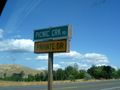
Private Road
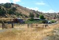
VERY private road
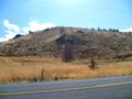
I made an effort of getting up this hill, but I'm glad I gave up; the hashpoint still would have been out of reach.


Achievements
Michael5000 earned the No trespassing consolation prize
|
Michael5000 earned the Multihash Achievement
|
- Six attempts and four successes in one long day.