Difference between revisions of "2011-09-23 50 8"
imported>Mampfred (Created page with "{{subst:Expedition |lat = 50 |lon = 8 |date = 2011-09-23 }}") |
imported>FippeBot m (Location) |
||
| (2 intermediate revisions by one other user not shown) | |||
| Line 1: | Line 1: | ||
| − | |||
| − | |||
| − | |||
| − | |||
| − | |||
| − | |||
| − | |||
| − | |||
| − | |||
| − | |||
{{meetup graticule | {{meetup graticule | ||
| lat=50 | | lat=50 | ||
| Line 15: | Line 5: | ||
}} | }} | ||
| − | |||
__NOTOC__ | __NOTOC__ | ||
== Location == | == Location == | ||
| − | + | Next to a soccer field in Heusenstamm. | |
== Participants == | == Participants == | ||
| − | + | *[[User:Mampfred|Mampfred]] | |
| + | *[[User:QuarterCacher|QuarterCacher]] | ||
== Plans == | == Plans == | ||
| − | + | Might go there after work. | |
== Expedition == | == Expedition == | ||
| − | + | Mampfred went there using public transport and met up with QuarterCacher near the hash. The soccer field turned out to be a former soccer field and seemed to be unused and filled with large heaps of earth and lots of junk. | |
| + | |||
| + | That turned out to be a good thing though as the hash was just behind the fence of the field and since it was unused it seemed to be frequented by all sorts of people using it as a shortcut. We headed in and found the hash in minutes. Placed a hash marker (facing the street), took some photos and went back to the car. | ||
| + | |||
| + | (We then actually had a go at a geocache at a near supermarket but failed to find the nano - as we do most of the time ;). | ||
== Tracklog == | == Tracklog == | ||
| − | + | See [http://www.everytrail.com/view_trip.php?trip_id=1299417 here]. | |
== Photos == | == Photos == | ||
| − | |||
| − | |||
| − | |||
<gallery perrow="5"> | <gallery perrow="5"> | ||
| + | Image:2011-09-23_50_8_yep_in_there.jpg | Entry to the field, got to be in there. | ||
| + | Image:2011-09-23_50_8_abandoned.jpg | Lots of junk inside. | ||
| + | Image:2011-09-23_50_8_coordinates.jpg | Coordinates ... | ||
| + | Image:2011-09-23_50_8_reached.jpg | ... reached. | ||
| + | Image:2011-09-23_50_8_hash.jpg | Look at the hash. | ||
| + | Image:2011-09-23_50_8_hasher.jpg | Successful hashers tired of grinning. | ||
| + | Image:2011-09-23_50_8_air_traffic.jpg | Busy air space. | ||
| + | Image:2011-09-23_50_8_marker.jpg | The (active geohasher) marker facing the street. | ||
</gallery> | </gallery> | ||
== Achievements == | == Achievements == | ||
{{#vardefine:ribbonwidth|800px}} | {{#vardefine:ribbonwidth|800px}} | ||
| − | + | {{Land geohash | |
| − | + | | latitude = 50 | |
| − | + | | longitude = 8 | |
| − | + | | date = 2011-09-23 | |
| − | + | | name = Mampfred and QuarterCacher | |
| − | [[ | + | }} |
| + | {{Consecutive_geohash | ||
| + | | latitude = 50 | ||
| + | | longitude = 8 | ||
| + | | count = 2 | ||
| + | | date = 2011-09-22 | ||
| + | | name = [[User:Mampfred|Mampfred]] | ||
| + | }} | ||
| − | |||
| − | |||
| − | |||
| − | |||
| − | |||
| − | |||
[[Category:Expeditions]] | [[Category:Expeditions]] | ||
| − | |||
[[Category:Expeditions with photos]] | [[Category:Expeditions with photos]] | ||
| − | |||
| − | |||
| − | |||
| − | |||
| − | |||
[[Category:Coordinates reached]] | [[Category:Coordinates reached]] | ||
| − | + | {{location|DE|HE|OF}} | |
| − | |||
| − | |||
| − | |||
| − | |||
| − | |||
| − | |||
| − | |||
| − | |||
| − | |||
Latest revision as of 00:58, 13 August 2019
| Fri 23 Sep 2011 in 50,8: 50.0588034, 8.7900782 geohashing.info google osm bing/os kml crox |
Location
Next to a soccer field in Heusenstamm.
Participants
Plans
Might go there after work.
Expedition
Mampfred went there using public transport and met up with QuarterCacher near the hash. The soccer field turned out to be a former soccer field and seemed to be unused and filled with large heaps of earth and lots of junk.
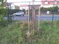
That turned out to be a good thing though as the hash was just behind the fence of the field and since it was unused it seemed to be frequented by all sorts of people using it as a shortcut. We headed in and found the hash in minutes. Placed a hash marker (facing the street), took some photos and went back to the car.
(We then actually had a go at a geocache at a near supermarket but failed to find the nano - as we do most of the time ;).
Tracklog
See here.
Photos

Entry to the field, got to be in there.
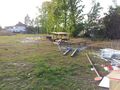
Lots of junk inside.
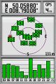
Coordinates ...

... reached.
Look at the hash.

Successful hashers tired of grinning.

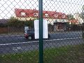
Busy air space.
The (active geohasher) marker facing the street.


Achievements
Mampfred and QuarterCacher earned the Land geohash achievement
|
Mampfred earned the Consecutive geohash achievement
|