Difference between revisions of "2011-10-29 -37 148"
imported>Talex ([live] Geohash success!) |
|||
| (14 intermediate revisions by 7 users not shown) | |||
| Line 1: | Line 1: | ||
| − | + | [[File:2011 10 29 -37 148 Truck.JPG|thumb|left|300px]] | |
| − | |||
| − | |||
| − | [[ | ||
| − | |||
| − | |||
| − | |||
| − | |||
| − | |||
| − | |||
{{meetup graticule | {{meetup graticule | ||
| lat=-37 | | lat=-37 | ||
| Line 15: | Line 6: | ||
}} | }} | ||
| − | |||
__NOTOC__ | __NOTOC__ | ||
== Location == | == Location == | ||
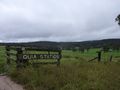
| − | + | In a paddock off a minor road near Buchan, in southeastern Victoria, Australia. | |
== Participants == | == Participants == | ||
| − | + | [[User:Stevage|Stevage]], [[User:Talex|tAlex]], [[User:Felix Dance|Felix Dance]] | |
| + | |||
| + | == Expedition == | ||
| + | We were headed for a few days of mountain biking in Snowy River National Park, an area of natural beauty, wildlife, and terrain so steep you don't even need a chain on your bike - you'll either be pushing uphill, or holding on for grim death as you scream downhill. We drove up to Buchan on Friday night, enduring a steady rainstorm that followed us all the way from Warragul. | ||
| − | + | Emerging from our four star accommodation (an information shelter next to a public toilet), we quickly set off in the car. A virgin graticule always creates a certain amount of excitement. Last night's drenching made the roads a bit iffy, so we declined to take the car down the last section of dirt track. | |
| − | + | ||
| + | We were at the edge of a farm, full of lush green fields, a few cows, and the odd rolling hill. The lush green fields were quite wet. "Here comes wet feet time", I accurately prognosticated. Not seeing anyone around, we hopped the fence, and began the few hundred wet, slushy metres to the point. | ||
| + | |||
| + | Suddenly a fence blocked our path. It looked vaguely...electrified. Felix, would you mind? Sure. He touched it with the back of his hand. Zap! Yes, electrified. Let's go around. | ||
| + | |||
| + | A few more metres and we were there. A graticule unlocked, and it wasn't even ten o'clock yet. | ||
| − | |||
<!-- how it all turned out. your narrative goes here. --> | <!-- how it all turned out. your narrative goes here. --> | ||
*Geohash success! -- [[User:Talex|Talex]] [http://www.openstreetmap.org/?lat=-37.5045846&lon=148.17059651&zoom=16&layers=B000FTF @-37.5046,148.1706] 09:29, 29 October 2011 (GMT+11:00) | *Geohash success! -- [[User:Talex|Talex]] [http://www.openstreetmap.org/?lat=-37.5045846&lon=148.17059651&zoom=16&layers=B000FTF @-37.5046,148.1706] 09:29, 29 October 2011 (GMT+11:00) | ||
| + | |||
| + | *Appears the geotaging didn't work, photos of the gpses to be uploaded later -- [[User:Talex|Talex]] 09:34, 29 October 2011 (GMT+11:00) | ||
== Tracklog == | == Tracklog == | ||
<!-- if your GPS device keeps a log, you may post a link here --> | <!-- if your GPS device keeps a log, you may post a link here --> | ||
== Photos == | == Photos == | ||
| − | |||
| − | |||
| − | |||
<gallery perrow="5"> | <gallery perrow="5"> | ||
| + | |||
| + | Image:2011-10-29_-37_148_09-30-10-941.jpg | [http://www.openstreetmap.org/?lat=-37.5496&lon=148.0640&zoom=16&layers=B000FTF @-37.5496,148.0640] | ||
| + | |||
| + | Image:2011-10-29_-37_148_09-30-34-596.jpg | [http://www.openstreetmap.org/?lat=-37.50046222&lon=148.17113218&zoom=16&layers=B000FTF @-37.5005,148.1711] | ||
| + | |||
| + | File:2011 10 29 -37 148 Hash.JPG|At the hash | ||
| + | File:2011 10 29 -37 148 GPSs.JPG|GPS proof | ||
| + | File:2011 10 29 -37 148 Sheep.JPG|Some nearby sheep | ||
| + | File:2011 10 29 -37 148 Leaving.JPG|Leaving the hash | ||
| + | File:2011 10 29 -37 148 Truck.JPG|Stevage driving a truck | ||
| + | File:2011 10 29 -37 148 Quia.JPG|A quia station nearby, hash in distance | ||
| + | |||
</gallery> | </gallery> | ||
== Achievements == | == Achievements == | ||
{{#vardefine:ribbonwidth|800px}} | {{#vardefine:ribbonwidth|800px}} | ||
| − | + | {{Graticule unlocked|latitude=-37|longitude=148|date=2011-10-29}} | |
| + | {{OpenStreetMap achievement|latitude=-37|longitude=148|date=2011-10-29|OSMlink=9709415}} | ||
| + | Also, the first of three consecutive geohashes. | ||
| − | |||
| − | |||
| − | |||
| − | |||
| − | |||
| − | |||
| − | |||
| − | |||
| − | |||
| − | |||
| − | |||
[[Category:Expeditions]] | [[Category:Expeditions]] | ||
| − | |||
[[Category:Expeditions with photos]] | [[Category:Expeditions with photos]] | ||
| − | |||
| − | |||
| − | |||
| − | |||
| − | |||
[[Category:Coordinates reached]] | [[Category:Coordinates reached]] | ||
| − | + | {{location|AU|VIC|EG}} | |
| − | |||
| − | |||
| − | |||
| − | |||
| − | |||
| − | |||
| − | |||
| − | |||
| − | |||
Latest revision as of 03:15, 27 March 2024

| Sat 29 Oct 2011 in -37,148: -37.5496219, 148.0636164 geohashing.info google osm bing/os kml crox |
Location
In a paddock off a minor road near Buchan, in southeastern Victoria, Australia.
Participants
Expedition
We were headed for a few days of mountain biking in Snowy River National Park, an area of natural beauty, wildlife, and terrain so steep you don't even need a chain on your bike - you'll either be pushing uphill, or holding on for grim death as you scream downhill. We drove up to Buchan on Friday night, enduring a steady rainstorm that followed us all the way from Warragul.
Emerging from our four star accommodation (an information shelter next to a public toilet), we quickly set off in the car. A virgin graticule always creates a certain amount of excitement. Last night's drenching made the roads a bit iffy, so we declined to take the car down the last section of dirt track.
We were at the edge of a farm, full of lush green fields, a few cows, and the odd rolling hill. The lush green fields were quite wet. "Here comes wet feet time", I accurately prognosticated. Not seeing anyone around, we hopped the fence, and began the few hundred wet, slushy metres to the point.
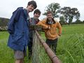
Suddenly a fence blocked our path. It looked vaguely...electrified. Felix, would you mind? Sure. He touched it with the back of his hand. Zap! Yes, electrified. Let's go around.
A few more metres and we were there. A graticule unlocked, and it wasn't even ten o'clock yet.
- Geohash success! -- Talex @-37.5046,148.1706 09:29, 29 October 2011 (GMT+11:00)
- Appears the geotaging didn't work, photos of the gpses to be uploaded later -- Talex 09:34, 29 October 2011 (GMT+11:00)
Tracklog
Photos
At the hash
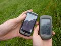
GPS proof
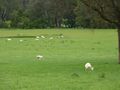
Some nearby sheep
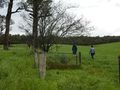
Leaving the hash
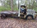
Stevage driving a truck
A quia station nearby, hash in distance


Achievements
This user earned the Graticule Unlocked Achievement
|
This user earned the OpenStreetMap achievement
|
Also, the first of three consecutive geohashes.