Difference between revisions of "2012-02-21 60 14"
imported>Fasanen (An expedition message sent via Geohash Droid for Android.) |
m (per Renaming Proposal) |
||
| (5 intermediate revisions by 3 users not shown) | |||
| Line 1: | Line 1: | ||
| − | |||
| − | |||
| − | |||
| − | |||
| − | |||
| − | |||
| − | |||
| − | |||
| − | |||
| − | |||
{{meetup graticule | {{meetup graticule | ||
| lat=60 | | lat=60 | ||
| Line 14: | Line 4: | ||
| date=2012-02-21 | | date=2012-02-21 | ||
}} | }} | ||
| − | |||
| − | |||
__NOTOC__ | __NOTOC__ | ||
== Location == | == Location == | ||
| − | + | ||
| + | In the woods north of Siljansnäs. | ||
== Participants == | == Participants == | ||
| − | + | [[User:Fasanen|Fasanen]] | |
== Plans == | == Plans == | ||
| − | + | Make history in a virgin graticule. | |
== Expedition == | == Expedition == | ||
| − | + | The whole family with grand parents went to Rättvik for the annual "sports"-vacation. Mr.T, who never ventured downhill skiing before, got an expert at it within hours and was hard to get from the slopes, so I had to do this expedition on my own. Rättvik is in 15th longitude but close to the border of the 14th so this was a lucky location. | |
| − | + | I skipped the afternoon skiing session and drove to Siljansnäs via Leksand. The last kilometer was on a very slippery road. I parked the car some 200 meters from the hash next to a pile of recently cut spruce. The scent compares to freshly brewed coffee and just unboxed electronics. I waded into the snowy woods but equipped with gaiters there was no problem getting to the geohash. I documented it and started backtracking when I heard a distant noise coming closer. After a few minutes a vehicle capable of traversing snow covered ground passed. I was not able to see it because of the dense wood, but I thought that walking its tracks would ease my way, so I turned my direction to where I heard the sound. I soon got to a marked snowmobile track and walked on it til I got to the main road where the car was parked. | |
| − | + | ||
| + | I took the scenic road back to Rättvik and had a closer look at the old steamer "Gustav Wasa" and the village of Tällberg. | ||
== Photos == | == Photos == | ||
| Line 37: | Line 27: | ||
--> | --> | ||
<gallery perrow="5"> | <gallery perrow="5"> | ||
| + | |||
| + | Image:2012-02-21_60_14_14-55-20-909.jpg | Success in new graticule! Happy Days! [http://www.openstreetmap.org/?lat=60.78086130&lon=14.89223058&zoom=16&layers=B000FTF @60.7809,14.8922] | ||
</gallery> | </gallery> | ||
== Achievements == | == Achievements == | ||
{{#vardefine:ribbonwidth|800px}} | {{#vardefine:ribbonwidth|800px}} | ||
| − | + | {{land geohash | latitude=60 | longitude=14 | date=2012-02-21 | name=Fasanen}} | |
| − | + | {{Graticule unlocked | latitude = 60 | longitude = 14 | date = 2012-02-21| name = [[User:Fasanen|Fasanen]]}} | |
| − | |||
| − | |||
| − | |||
| − | [[ | ||
| − | |||
| − | |||
| − | |||
| − | |||
| − | |||
| − | |||
[[Category:Expeditions]] | [[Category:Expeditions]] | ||
| − | |||
[[Category:Expeditions with photos]] | [[Category:Expeditions with photos]] | ||
| − | [[Category: | + | [[Category:Coordinates reached]] |
| − | [[Category: | + | [[Category:Sweden]] |
| − | |||
<!-- if you reached your coords: | <!-- if you reached your coords: | ||
| Line 73: | Line 53: | ||
[[Category:Not reached - Did not attempt]] when you went to an alternate location, or decided early on to abort the expedition. | [[Category:Not reached - Did not attempt]] when you went to an alternate location, or decided early on to abort the expedition. | ||
--> | --> | ||
| + | {{location|SE|W}} | ||
Latest revision as of 05:45, 20 March 2024
| Tue 21 Feb 2012 in 60,14: 60.7808811, 14.8922065 geohashing.info google osm bing/os kml crox |
Location
In the woods north of Siljansnäs.
Participants
Plans
Make history in a virgin graticule.
Expedition
The whole family with grand parents went to Rättvik for the annual "sports"-vacation. Mr.T, who never ventured downhill skiing before, got an expert at it within hours and was hard to get from the slopes, so I had to do this expedition on my own. Rättvik is in 15th longitude but close to the border of the 14th so this was a lucky location.
I skipped the afternoon skiing session and drove to Siljansnäs via Leksand. The last kilometer was on a very slippery road. I parked the car some 200 meters from the hash next to a pile of recently cut spruce. The scent compares to freshly brewed coffee and just unboxed electronics. I waded into the snowy woods but equipped with gaiters there was no problem getting to the geohash. I documented it and started backtracking when I heard a distant noise coming closer. After a few minutes a vehicle capable of traversing snow covered ground passed. I was not able to see it because of the dense wood, but I thought that walking its tracks would ease my way, so I turned my direction to where I heard the sound. I soon got to a marked snowmobile track and walked on it til I got to the main road where the car was parked.
I took the scenic road back to Rättvik and had a closer look at the old steamer "Gustav Wasa" and the village of Tällberg.
Photos
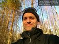
Success in new graticule! Happy Days! @60.7809,14.8922

Achievements
Fasanen earned the Land geohash achievement
|
Fasanen earned the Graticule Unlocked Achievement
|