Difference between revisions of "2012-02-26 50 8"
imported>QuarterCacher (An expedition message sent via Geohash Droid for Android.) |
imported>FippeBot m (Location) |
||
| (6 intermediate revisions by 3 users not shown) | |||
| Line 1: | Line 1: | ||
| − | |||
| − | |||
| − | |||
| − | |||
| − | |||
| − | |||
| − | |||
| − | |||
| − | |||
| − | |||
{{meetup graticule | {{meetup graticule | ||
| lat=50 | | lat=50 | ||
| Line 15: | Line 5: | ||
}} | }} | ||
| − | <!-- | + | <!-- shamelessly stolen from [[2008-08-16_52_12/Map]] --> |
| + | <table style="border-width: 1px; border-spacing: 0px; border-style: solid solid solid solid; border-color: lightgray;"> | ||
| + | <tr> | ||
| + | <td style="border-width: 5px; border-spacing: 2px; border-style: hidden hidden hidden solid; border-color: #8268ed; border-collapse: separate;"></td> | ||
| + | <td style="padding: 0px 12px 0px 10px;">Multihash x 2: [[2012-02-26 49 8|Karlsruhe]], [[2012-02-26 50 8|Rüsselsheim]]</td> | ||
| + | </tr> | ||
| + | </table> | ||
| + | |||
__NOTOC__ | __NOTOC__ | ||
== Location == | == Location == | ||
| − | + | In the woods next to the Autobahn close to Rüsselsheim. | |
== Participants == | == Participants == | ||
| − | + | * [[User:QuarterCacher|QuarterCacher]] | |
| + | * [[User:M|M]] | ||
| + | * [[User:Mampfred|Mampfred]] | ||
== Plans == | == Plans == | ||
| − | + | === Mampfred === | |
| + | Coming from a tap dance seminar mentioned [[2012-02-26 49 8|here]] this also is conveniently close to the Autobahn which makes it a prime candidate for the second part of a multihash. | ||
== Expedition == | == Expedition == | ||
| − | + | === QuarterCacher and M === | |
| + | They went to the hashpoint first ... | ||
| + | |||
| + | === Mampfred === | ||
| + | QuarterCacher had already texted me that he'd been to today's 50 8 but since I had a | ||
| + | multihash to do I went anyway. QuarterCacher was nice enough to also text me the coordinates | ||
| + | to the nearest parking lot so I headed straight there and started walking. | ||
| + | |||
| + | The hash was | ||
| + | easily reached at about 1.8 km away from the parking lot. | ||
== Tracklog == | == Tracklog == | ||
| − | + | === Mampfred === | |
| + | See [http://www.everytrail.com/view_trip.php?trip_id=1464128 here]. | ||
== Photos == | == Photos == | ||
| − | + | === QuarterCacher and M === | |
| − | |||
| − | |||
<gallery perrow="5"> | <gallery perrow="5"> | ||
| + | Image:2012-02-26_50_8_12-49-22-003.jpg | Coordinates reached. [http://www.openstreetmap.org/?lat=50.00027195&lon=8.48375545&zoom=16&layers=B000FTF @50.0003,8.4838] | ||
| + | </gallery> | ||
| + | |||
| + | === Mampfred === | ||
| + | <gallery perrow=5> | ||
| + | Image:201202-26_50_8_to_the_hash.jpg | The hash should be straight ahead on this track ... | ||
| + | Image:201202-26_50_8_right_this_way.jpg | ... this track to be precise. At least OSM is showing a track here ... | ||
| + | Image:201202-26_50_8_wo_ein_wille.jpg | ... ah, this track they mean :) | ||
| + | Image:201202-26_50_8_coordinates.jpg | Coordinates ... | ||
| + | Image:201202-26_50_8_reached.jpg | ... reached. | ||
| + | Image:201202-26_50_8_hash.jpg | Looking at the hash. | ||
| + | Image:201202-26_50_8_grin.jpg | Stupid grin. | ||
</gallery> | </gallery> | ||
== Achievements == | == Achievements == | ||
{{#vardefine:ribbonwidth|800px}} | {{#vardefine:ribbonwidth|800px}} | ||
| − | + | * Land | |
| + | * QuarterCacher and M: Earliest Geohasher | ||
| + | {{Multihash | ||
| + | | latitude1 = 49 | ||
| + | | longitude1 = 8 | ||
| + | | latitude2 = 50 | ||
| + | | longitude2 = 8 | ||
| + | | date = 2012-02-26 | ||
| + | | name = Mampfred | ||
| + | }} | ||
| − | |||
| − | |||
| − | |||
| − | |||
| − | |||
| − | |||
| − | |||
| − | |||
| − | |||
| − | |||
| − | |||
[[Category:Expeditions]] | [[Category:Expeditions]] | ||
| − | |||
[[Category:Expeditions with photos]] | [[Category:Expeditions with photos]] | ||
| − | |||
| − | |||
| − | |||
| − | |||
| − | |||
[[Category:Coordinates reached]] | [[Category:Coordinates reached]] | ||
| − | + | {{location|DE|HE|GG}} | |
| − | |||
| − | |||
| − | |||
| − | |||
| − | |||
| − | |||
| − | |||
| − | |||
| − | |||
Latest revision as of 02:33, 13 August 2019
| Sun 26 Feb 2012 in 50,8: 50.0000466, 8.4837187 geohashing.info google osm bing/os kml crox |
| Multihash x 2: Karlsruhe, Rüsselsheim |
Location
In the woods next to the Autobahn close to Rüsselsheim.
Participants
Plans
Mampfred
Coming from a tap dance seminar mentioned here this also is conveniently close to the Autobahn which makes it a prime candidate for the second part of a multihash.
Expedition
QuarterCacher and M
They went to the hashpoint first ...
Mampfred
QuarterCacher had already texted me that he'd been to today's 50 8 but since I had a multihash to do I went anyway. QuarterCacher was nice enough to also text me the coordinates to the nearest parking lot so I headed straight there and started walking.
The hash was easily reached at about 1.8 km away from the parking lot.
Tracklog
Mampfred
See here.
Photos
QuarterCacher and M

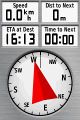
Coordinates reached. @50.0003,8.4838

Mampfred
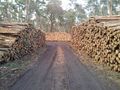
The hash should be straight ahead on this track ...
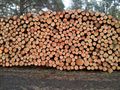
... this track to be precise. At least OSM is showing a track here ...
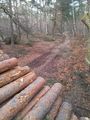
... ah, this track they mean :)
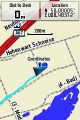
Coordinates ...
... reached.
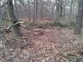
Looking at the hash.

Stupid grin.


Achievements
- Land
- QuarterCacher and M: Earliest Geohasher
Mampfred earned the Multihash Achievement
|