Difference between revisions of "2012-02-29 33 -102"
From Geohashing
imported>GFrohman |
m (per Renaming Proposal) |
||
| (2 intermediate revisions by 2 users not shown) | |||
| Line 34: | Line 34: | ||
}} | }} | ||
| − | {{ | + | {{Graticule unlocked |
| latitude = 33 | | latitude = 33 | ||
| longitude = -102 | | longitude = -102 | ||
| Line 45: | Line 45: | ||
Image:AREA_SHOT.JPG|GFroh's Area Pic | Image:AREA_SHOT.JPG|GFroh's Area Pic | ||
</gallery> | </gallery> | ||
| + | |||
| + | [[Category:Expeditions]] | ||
| + | [[Category:Expeditions with photos]] | ||
| + | [[Category:Coordinates reached]] | ||
| + | {{location|US|TX|TE}} | ||
Latest revision as of 05:45, 20 March 2024
| Wed 29 Feb 2012 in Levelland: 33.3129303, -102.1794689 geohashing.info google osm bing/os kml crox |
Location
2012 Leap Day Geohash!
In a farm area, outside of Meadow, near Brownfield, Texas.
Weather (16:00): Sunny, hot
Participants
Expedition
Got to this one rather easily. Just drove near, walked over, and took the picture!
Ribbons
GFrohman earned the Land geohash achievement
|
GFrohman earned the Leap geohash achievement 2012
|
GFrohman earned the Graticule Unlocked Achievement
|
Images
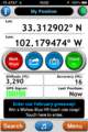
GFroh's GPS Tag

GFroh's Area Pic

