Difference between revisions of "2012-03-14 62 17"
imported>Penthok |
imported>FippeBot m (Location) |
||
| (3 intermediate revisions by 2 users not shown) | |||
| Line 34: | Line 34: | ||
--> | --> | ||
<gallery perrow="3"> | <gallery perrow="3"> | ||
| − | Image:2012-03-12_62_17_-_P1_-_Church.JPG | | + | Image:2012-03-12_62_17_-_P1_-_Church.JPG | The church near the hashpoint. |
| − | Image:2012-03-12_62_17_-_P2_-_Trail.JPG | | + | Image:2012-03-12_62_17_-_P2_-_Trail.JPG | I found this trail leading towards the hashpoint, but not quite it turned out. |
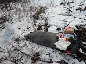
| − | Image:2012-03-12_62_17_-_P3_-_Picnic.JPG | | + | Image:2012-03-12_62_17_-_P3_-_Picnic.JPG | Setting up a picnic at the hashpoint! Showing my map, meal and snowman. |
| − | Image:2012-03-12_62_17_-_P4_-_Snowman.JPG | | + | Image:2012-03-12_62_17_-_P4_-_Snowman.JPG | Closeup of my snowman. The snow was clearly not suited for snowman building. |
| − | Image:2012-03-12_62_17_-_P5_-_Grin.JPG | | + | Image:2012-03-12_62_17_-_P5_-_Grin.JPG | Me grinning with... the horrible abomination of cutlery. A spoon, fork and knife all in one. Scary... |
| − | Image:2012-03-12_62_17_-_P6_-_Pie.JPG | | + | Image:2012-03-12_62_17_-_P6_-_Pie.JPG | The Pi day pie. |
</gallery> | </gallery> | ||
| Line 95: | Line 95: | ||
| − | <!-- =============== USEFUL CATEGORIES FOLLOW ================ | + | <!-- =============== USEFUL CATEGORIES FOLLOW ================ --> |
[[Category:Expeditions]] | [[Category:Expeditions]] | ||
[[Category:Expeditions with photos]] | [[Category:Expeditions with photos]] | ||
<!-- [[Category:Expeditions with videos]] --> | <!-- [[Category:Expeditions with videos]] --> | ||
[[Category:Expedition without GPS]] | [[Category:Expedition without GPS]] | ||
| + | [[Category:Coordinates reached]] | ||
| + | {{location|SE|Y}} | ||
Latest revision as of 02:56, 13 August 2019
| Wed 14 Mar 2012 in 62,17: 62.2537601, 17.3619844 geohashing.info google osm bing/os kml crox |
Location
In a clearing near Njurundabommen, south of Sundsvall.
Participants
Plans
Of course I need to go hashing on Pi day! So I scouted the possible points and decided on the one in my home graticule.
Expedition
So I headed out towards the hashpoint, stopping by at McDonalds (unfortunately the only fast food place I knew that have pies) and then continuing down to the hashpoint. I parked at the parking lot outside the nearby church and started walking towards the point. I was a bit worried that it had ended up in the middle of the new road being built near there. I passed a bridge being built for it before turning off the road and heading into the forest. After a little walk I found the hashpoint in a small clearing next to a meadow so I set up camp there. Rolling out the, uh, "colorful tablecloth", putting up my picnic bag of burgers and taking out my eating utensils. Next I built a snowman next to the point and sat down and enjoyed my burgers and pie, sad over the fact that despite the day, I would not quite qualify for the Pie Geohash achievement. After that I explored the area and found a trap! Then I packed up and returned home.
Tracklog
Still no GPS.
Photos
Achievements
Penthok earned the Land geohash achievement
|
Penthok earned the No Batteries Geohash Achievement
|
Penthok earned the Picnic achievement
|
Penthok earned the Snowman Geohash Achievement
|
Is it true that Penthok earned the Pie Geohash?
|


