Difference between revisions of "2012-03-29 33 -116"
From Geohashing
imported>LucasBrown (→Participants) |
imported>FippeBot m (Location) |
||
| (One intermediate revision by one other user not shown) | |||
| Line 1: | Line 1: | ||
| − | |||
<!-- If you did not specify these parameters in the template, please substitute appropriate values for IMAGE, LAT, LON, and DATE (YYYY-MM-DD format) | <!-- If you did not specify these parameters in the template, please substitute appropriate values for IMAGE, LAT, LON, and DATE (YYYY-MM-DD format) | ||
| Line 15: | Line 14: | ||
}} | }} | ||
| − | + | ||
__NOTOC__ | __NOTOC__ | ||
== Location == | == Location == | ||
| Line 21: | Line 20: | ||
== Participants == | == Participants == | ||
| − | + | ||
| − | [[User:LucasBrown|LucasBrown]] dragged his mother, sister, and dog along. | + | * [[User:LucasBrown|LucasBrown]] dragged his |
| + | * mother, | ||
| + | * sister, and dog along. | ||
== Plans == | == Plans == | ||
| Line 32: | Line 33: | ||
*Hi! -- [[User:LucasBrown|LucasBrown]] [http://www.openstreetmap.org/?lat=33.00563475&lon=-116.81731248&zoom=16&layers=B000FTF @33.0056,-116.8173] 21:10, 29 March 2012 (EDT) | *Hi! -- [[User:LucasBrown|LucasBrown]] [http://www.openstreetmap.org/?lat=33.00563475&lon=-116.81731248&zoom=16&layers=B000FTF @33.0056,-116.8173] 21:10, 29 March 2012 (EDT) | ||
| + | |||
== Tracklog == | == Tracklog == | ||
<!-- if your GPS device keeps a log, you may post a link here --> | <!-- if your GPS device keeps a log, you may post a link here --> | ||
| Line 48: | Line 50: | ||
<!-- Add any achievement ribbons you earned below, or remove this section --> | <!-- Add any achievement ribbons you earned below, or remove this section --> | ||
| + | * Land geohash | ||
| − | |||
| − | |||
| − | |||
| − | |||
| − | |||
| − | |||
| − | |||
| − | |||
[[Category:Expeditions]] | [[Category:Expeditions]] | ||
| − | + | ||
[[Category:Expeditions with photos]] | [[Category:Expeditions with photos]] | ||
| − | |||
| − | |||
| − | |||
| − | |||
| − | |||
[[Category:Coordinates reached]] | [[Category:Coordinates reached]] | ||
| − | + | {{location|US|CA|SD}} | |
| − | |||
| − | |||
| − | |||
| − | |||
| − | |||
| − | |||
| − | |||
| − | |||
| − | |||
Latest revision as of 03:14, 13 August 2019
| Thu 29 Mar 2012 in 33,-116: 33.0056429, -116.8173162 geohashing.info google osm bing/os kml crox |
Location
In the middle of a median on San Vincente Road, Ramona, CA
Participants
- LucasBrown dragged his
- mother,
- sister, and dog along.
Plans
Expedition
- Hi! -- LucasBrown @33.0056,-116.8173 21:10, 29 March 2012 (EDT)
Tracklog
Photos
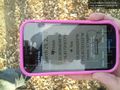
Photo of Geohash Droid showing phone's location to be 11 cm away from the target. @33.0056,-116.8173

Achievements
- Land geohash