Difference between revisions of "2012-05-09 42 -87"
imported>RocketMac (Created page with "{{Subst:expedition | lat = 42 | lon = -87 | date = 2012-05-09 }}") |
imported>FippeBot m (Location) |
||
| (8 intermediate revisions by 2 users not shown) | |||
| Line 1: | Line 1: | ||
| − | |||
| − | |||
| − | |||
| − | |||
| − | |||
{{meetup graticule | {{meetup graticule | ||
| lat=42 | | lat=42 | ||
| Line 10: | Line 5: | ||
}} | }} | ||
| − | + | ||
| − | |||
== Location == | == Location == | ||
| − | + | The corner of 10th and Monroe in South Milwaukee, WI. | |
== Participants == | == Participants == | ||
| − | + | *[[User:RocketMac|RocketMac]] | |
| − | + | * The Wyf | |
== Plans == | == Plans == | ||
| − | + | After work, I need to run home to attend to the dogs, but I'll make a run hopefully before dark. | |
== Expedition == | == Expedition == | ||
| − | + | After I made it home, I tended to the needs of the dogs while The Wyf was wrapping up downtown. When she called to let me know she was on the way, we discussed dinner options. I mentioned my desire to reach the hashpoint for the day and she suggested I look up restaurants near the hashpoint. I love my wife! | |
| + | |||
| + | When she got here, we got ready and started out. I set my GPS running and off we went. | ||
| + | |||
| + | It was early dusk when we made the hashpoint. The surrounding area was almost exactly as the Google Maps Street View had suggested. Now, however, I could make out the details better. The main business, for example, was a laundromat with actual working payphone nearby. Across the street was an American Legion Post with a really nice mural on its wall. Next door to the laundromat was an odd shop with a window full of duck figurines. | ||
| + | |||
| + | When I first scoped out the spot, I saw there was a [http://geocaching.com geocache] only 250 feet from the hashpoint. Three things prevented me from heading off to find it. a) I was already hungry and didn't want to take the time; b) The Wyf was going along with the geohash, I didn't want to push my luck and; c) I was up to geocache find #665 and I was reserving #666 for a particularly nasty cache I had attempted before. Plus I already had a couple of Hash Collision awards and didn't need this one. | ||
| + | |||
| + | While I was taking photos, The Wyf found some other dining options nearby. We opted for Johnny Mo's for burgers, beer and they had tater tots on the menu! The place was nice enough. It's clearly a neighborhood bar, but the menu had some nice options, they had Strongbow (my favorite) on tap, and did I mention the tater tots?! | ||
| + | |||
| + | I took a picture of a sign that read "Rocket Country" and, not knowing the background, just thought it was a nice coincidence with my callsign, RocketMac. Turns out that the local high school team is the "South Milwaukee Rockets" so that made sense. Still a nice touch, though. | ||
| + | |||
| + | Now I ''could'' have gone into the American Legion for a drink or to a nearby bar to claim the [[Pub Geohash]] award, but in the spirit of the expedition, I'm attaching the award to this trip since we did enjoy a pint as part of the expedition itself. This is the third "random dinner generator" expedition The Wyf has joined me on, and if I could have been on top of the hashpoint building, the pub would have been in line of sight. | ||
== Tracklog == | == Tracklog == | ||
| − | + | The tracklog can be seen in [http://coldshadow.com/geohashing/2012-05-09.gpx GPX] and [http://coldshadow.com/geohashing/2012-05-09.kmz KMZ] formats. | |
== Photos == | == Photos == | ||
| − | |||
| − | |||
| − | |||
<gallery perrow="5"> | <gallery perrow="5"> | ||
| + | Image:RocketMac 2012-05-09 42 -87 01.jpg | Stupid Grin | ||
| + | Image:RocketMac 2012-05-09 42 -87 02.png | GPS Reading | ||
| + | Image:RocketMac 2012-05-09 42 -87 03.jpg | Legion Hall | ||
| + | Image:RocketMac 2012-05-09 42 -87 04.jpg | Mural on Side of Building | ||
| + | Image:RocketMac 2012-05-09 42 -87 08.jpg | Odd Array of Ducks | ||
| + | Image:RocketMac 2012-05-09 42 -87 05.jpg | RocketMac and The Wyf | ||
| + | Image:RocketMac 2012-05-09 42 -87 06.jpg | Ahhhh. Strongbow on Tap! | ||
| + | Image:RocketMac 2012-05-09 42 -87 07.jpg | RocketMac in Rocket Country | ||
</gallery> | </gallery> | ||
== Achievements == | == Achievements == | ||
{{#vardefine:ribbonwidth|800px}} | {{#vardefine:ribbonwidth|800px}} | ||
| − | + | {{land geohash | |
| − | + | | latitude = 42 | |
| − | + | | longitude = -87 | |
| − | + | | date = 2012-05-09 | |
| − | + | | name = RocketMac | |
| − | + | | image = | |
| − | + | }} | |
| − | + | {{drag-along | |
| − | + | | latitude = 42 | |
| − | + | | longitude = -87 | |
| − | + | | date = 2012-05-09 | |
| + | | partner = MusicGirl (aka The Wyf) | ||
| + | | name = RocketMac | ||
| + | | image = | ||
| + | }} | ||
| + | {{pub geohash | ||
| + | | latitude = 42 | ||
| + | | longitude = -87 | ||
| + | | date = 2012-05-09 | ||
| + | | name = RocketMac | ||
| + | | image = | ||
| + | }} | ||
| − | |||
[[Category:Expeditions]] | [[Category:Expeditions]] | ||
| − | |||
[[Category:Expeditions with photos]] | [[Category:Expeditions with photos]] | ||
| − | |||
| − | |||
| − | |||
| − | |||
| − | |||
[[Category:Coordinates reached]] | [[Category:Coordinates reached]] | ||
| − | + | {{location|US|WI|MU}} | |
| − | |||
| − | |||
| − | |||
| − | |||
| − | |||
| − | |||
| − | |||
| − | |||
| − | |||
Latest revision as of 03:53, 13 August 2019
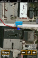
| Wed 9 May 2012 in 42,-87: 42.9115242, -87.8602291 geohashing.info google osm bing/os kml crox |
Location
The corner of 10th and Monroe in South Milwaukee, WI.
Participants
- RocketMac
- The Wyf
Plans
After work, I need to run home to attend to the dogs, but I'll make a run hopefully before dark.
Expedition
After I made it home, I tended to the needs of the dogs while The Wyf was wrapping up downtown. When she called to let me know she was on the way, we discussed dinner options. I mentioned my desire to reach the hashpoint for the day and she suggested I look up restaurants near the hashpoint. I love my wife!
When she got here, we got ready and started out. I set my GPS running and off we went.
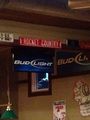
It was early dusk when we made the hashpoint. The surrounding area was almost exactly as the Google Maps Street View had suggested. Now, however, I could make out the details better. The main business, for example, was a laundromat with actual working payphone nearby. Across the street was an American Legion Post with a really nice mural on its wall. Next door to the laundromat was an odd shop with a window full of duck figurines.
When I first scoped out the spot, I saw there was a geocache only 250 feet from the hashpoint. Three things prevented me from heading off to find it. a) I was already hungry and didn't want to take the time; b) The Wyf was going along with the geohash, I didn't want to push my luck and; c) I was up to geocache find #665 and I was reserving #666 for a particularly nasty cache I had attempted before. Plus I already had a couple of Hash Collision awards and didn't need this one.
While I was taking photos, The Wyf found some other dining options nearby. We opted for Johnny Mo's for burgers, beer and they had tater tots on the menu! The place was nice enough. It's clearly a neighborhood bar, but the menu had some nice options, they had Strongbow (my favorite) on tap, and did I mention the tater tots?!
I took a picture of a sign that read "Rocket Country" and, not knowing the background, just thought it was a nice coincidence with my callsign, RocketMac. Turns out that the local high school team is the "South Milwaukee Rockets" so that made sense. Still a nice touch, though.
Now I could have gone into the American Legion for a drink or to a nearby bar to claim the Pub Geohash award, but in the spirit of the expedition, I'm attaching the award to this trip since we did enjoy a pint as part of the expedition itself. This is the third "random dinner generator" expedition The Wyf has joined me on, and if I could have been on top of the hashpoint building, the pub would have been in line of sight.
Tracklog
The tracklog can be seen in GPX and KMZ formats.
Photos

Stupid Grin
GPS Reading
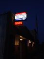
Legion Hall
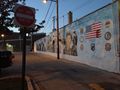
Mural on Side of Building
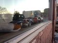
Odd Array of Ducks

RocketMac and The Wyf
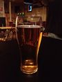
Ahhhh. Strongbow on Tap!
RocketMac in Rocket Country


Achievements
RocketMac earned the Land geohash achievement
|
RocketMac earned the Drag-along achievement
|
RocketMac earned the Pub Geohash Achievement
|