Difference between revisions of "2012-05-27 63 27"
imported>Seseler (Created page with "{{subst:Expedition |lat = 63|lon = 27|date = 2012-05-27}}") |
imported>FippeBot m (Location) |
||
| (4 intermediate revisions by 2 users not shown) | |||
| Line 1: | Line 1: | ||
| − | |||
<!-- If you did not specify these parameters in the template, please substitute appropriate values for IMAGE, LAT, LON, and DATE (YYYY-MM-DD format) | <!-- If you did not specify these parameters in the template, please substitute appropriate values for IMAGE, LAT, LON, and DATE (YYYY-MM-DD format) | ||
| Line 18: | Line 17: | ||
__NOTOC__ | __NOTOC__ | ||
== Location == | == Location == | ||
| − | + | North of Rissala | |
== Participants == | == Participants == | ||
| − | + | *[[User:Seseler|Seseler]] | |
| − | + | *My brother | |
| + | *My mother | ||
| − | |||
| − | |||
== Expedition == | == Expedition == | ||
| − | + | We decided to drive as close to the geohash as we could. We left the car in yard of an old abandoned-looking house. | |
| + | At first we thought that the hash was on the open field. However, as we aproached the edge of a forest we realized that the hash would be in it. | ||
| + | |||
| + | After we had entered the forest through dense wall of willows, the forest was quite easy to travel. Until we encountered the cliff. The cliff was about ten metres high and it took us a few minutes to find a suitable climbing spot and few minutes to climb. After reaching the top there still was about 150 metres to the hash. Since the forest was a bit denser at the top and we still traveled uphill, it took us a bit of time to reach the point. However when we were about 30 metres away, we found a path going almost directly to the hash. The geohash was in an open spot in middle of the forest, on the top of the hill. | ||
| − | |||
| − | |||
== Photos == | == Photos == | ||
| − | + | ||
| − | |||
| − | |||
<gallery perrow="5"> | <gallery perrow="5"> | ||
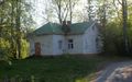
| + | Image:2012-05-27 63 27 Cottage.JPG | ||
| + | Image:2012-05-27 63 27 field1.JPG |My brother walking through fields. | ||
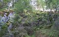
| + | Image:2012-05-27 63 27 cliff.JPG | ||
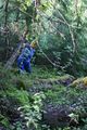
| + | Image:2012-05-27 63 27 forest.JPG | ||
| + | Image:2012-05-27 63 27 goinguphill.JPG | ||
| + | Image:2012-05-27 63 27 forest2.JPG | ||
| + | Image:2012-05-27 63 27 proof.JPG | ||
| + | Image:2012-05-27 63 27 path.JPG | The path going back to the road. | ||
| + | Image:2012-05-27 63 27 lake.JPG | ||
</gallery> | </gallery> | ||
== Achievements == | == Achievements == | ||
{{#vardefine:ribbonwidth|800px}} | {{#vardefine:ribbonwidth|800px}} | ||
| − | |||
| + | {{land geohash | latitude = 63 | longitude = 27 | date = 2012-05-27 | name = Seseler }} | ||
<!-- =============== USEFUL CATEGORIES FOLLOW ================ | <!-- =============== USEFUL CATEGORIES FOLLOW ================ | ||
Delete the next line ONLY if you have chosen the appropriate categories below. If you are unsure, don't worry. People will read your report and help you with the classification. --> | Delete the next line ONLY if you have chosen the appropriate categories below. If you are unsure, don't worry. People will read your report and help you with the classification. --> | ||
| − | [[Category: | + | [[Category:Expeditions]] |
| + | [[Category:Expeditions with photos]] | ||
| + | [[Category:Coordinates reached]] | ||
<!-- Potential categories. Please include all the ones appropriate to your expedition --> | <!-- Potential categories. Please include all the ones appropriate to your expedition --> | ||
| Line 74: | Line 82: | ||
[[Category:Not reached - Did not attempt]] when you went to an alternate location, or decided early on to abort the expedition. | [[Category:Not reached - Did not attempt]] when you went to an alternate location, or decided early on to abort the expedition. | ||
--> | --> | ||
| + | {{location|FI|15}} | ||
Latest revision as of 04:16, 13 August 2019
| Sun 27 May 2012 in 63,27: 63.0161098, 27.6978975 geohashing.info google osm bing/os kml crox |
Location
North of Rissala
Participants
- Seseler
- My brother
- My mother
Expedition
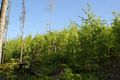
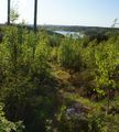
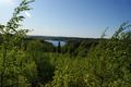
We decided to drive as close to the geohash as we could. We left the car in yard of an old abandoned-looking house. At first we thought that the hash was on the open field. However, as we aproached the edge of a forest we realized that the hash would be in it.
After we had entered the forest through dense wall of willows, the forest was quite easy to travel. Until we encountered the cliff. The cliff was about ten metres high and it took us a few minutes to find a suitable climbing spot and few minutes to climb. After reaching the top there still was about 150 metres to the hash. Since the forest was a bit denser at the top and we still traveled uphill, it took us a bit of time to reach the point. However when we were about 30 metres away, we found a path going almost directly to the hash. The geohash was in an open spot in middle of the forest, on the top of the hill.
Photos
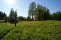
My brother walking through fields.

The path going back to the road.


Achievements
Seseler earned the Land geohash achievement
|